Jim Corbett National Park

Last updated

Jim Corbett National Park
Bengal-Tiger Corbett Uttarakhand Dec-2013.jpg
Bengal tiger in Corbett National Park
India Uttarakhand relief map.svg
Red pog.svg
India relief location map.jpg
Red pog.svg
Location Nainital,Uttarakhand, India
Nearest city Ramnagar, Kotdwar
Coordinates 29°32′55″N78°56′7″E / 29.54861°N 78.93528°E / 29.54861; 78.93528
Area1,318 km2
Established1936
Visitors500,000 [1] (in 1999)
Governing body Project Tiger, Government of Uttarakhand, Wildlife Warden, Jim Corbett National Park
corbettonline.uk.gov.in

Jim Corbett National Park is a national park in India located in the Nainital district of Uttarakhand state. The first national park in India, it was established in 1936 during the British Raj and named Hailey National Park after William Malcolm Hailey, a governor of the United Provinces in which it was then located. In 1956, nearly a decade after India's independence, it was renamed Corbett National Park after the hunter and naturalist Jim Corbett, who had played a leading role in its establishment and had died the year before. The park was the first to come under the Project Tiger initiative. [2]

Contents

Corbett National Park comprises 520.8 km2 (201.1 sq mi) area of hills, riverine belts, marshy depressions, grasslands and a large lake. The elevation ranges from 1,300 to 4,000 ft (400 to 1,220 m). Winter nights are cold but the days are bright and sunny. It rains from July to September. The park has sub-Himalayan belt geographical and ecological characteristics. [3] Dense moist deciduous forest mainly consists of Shorea robusta (the sal tree), haldu, peepal, rohini and mango trees. Forest covers almost 73 per cent of the park, while 10 per cent of the area consists of grasslands. It houses around 110 tree species, 50 species of mammals, 580 bird species and 25 reptile species.

An ecotourism destination, [4] the park contains 617 different species of plants and a diverse variety of fauna. [5] [6] The increase in tourist activities, among other problems, continues to present a serious challenge to the park's ecological balance. [7]

History

Indian monitor lizard Indian Monitor Lizard - JTR.jpg
Indian monitor lizard
A chital in Jim Corbett National Park A spotted deer or Chital in Jim Corbett national park looking straight to the camera.jpg
A chital in Jim Corbett National Park

Some areas of the park were formerly part of the princely state of Tehri Garhwal. [8] The forests were cleared by the Environment and Forests Department (Uttarakhand) to make the area less vulnerable to Rohilla invaders. [8] The Raja of Tehri formally ceded a part of his princely state to the East India Company in return for their assistance in ousting the Gurkhas from his domain. [8] The Buksas—a tribe from the Terai—settled on the land and began growing crops, but in the early 1860s they were evicted with the advent of British rule. [8]

Efforts to save the forests of the region began in the 19th century under Major Ramsay, the British officer who was in-charge of the area during those times. The first step in the protection of the area began in 1868 when the British forest department established control over the land and prohibited cultivation and the operation of cattle stations. [9] In 1879 these forests were constituted into a reserve forest where restricted felling was permitted.

In the early 1900s, several Britishers, including E. R. Stevans and E. A. Smythies, suggested the setting up of a national park on this soil. The British administration considered the possibility of creating a game reserve there in 1907. [9] It was only in the 1930s that the process of demarcation for such an area got underway. A reserve area known as Hailey National Park covering 323.75 km2 (125.00 sq mi) was created in 1936, when Sir Malcolm Hailey was the Governor of United Provinces, and Asia's first national park came into existence. [10] Hunting was not allowed in the reserve, only timber cutting for domestic purposes was permitted. Soon after the establishment of the reserve, rules prohibiting the killing and capture of mammals, reptiles and birds within its boundaries were passed. [10]

The reserve was renamed Ramganga National Park in 1954–1955 and was again renamed in 1955–1956 to Corbett National Park after author and naturalist Jim Corbett. [10] The park fared well during the 1930s under an elected administration. But during the Second World War, it suffered from excessive poaching and timber cutting. Over time, the area in the reserve was increased to 797.72 km2 (308.00 sq mi) were added in 1991 as a buffer zone to the Corbett Tiger Reserve. [10] The 1991 addition included the entire Kalagarh forest division, assimilating the 301.18 km2 (116.29 sq mi) area of Sonanadi Wildlife Sanctuary as a part of the Kalagarh division. [10] It was chosen in 1974 as the location for launching the Project Tiger wildlife conservation project. [11] The reserve is administered from its headquarters in the Nainital district. [9]

Corbett National Park is one of the thirteen protected areas covered by the World Wide Fund For Nature under their Terai Arc Landscape Program. [12] The program aims to protect three of the five terrestrial flagship species, the tiger, the Asian elephant and the Indian rhinoceros by restoring wildlife corridors to link 13 protected areas of Nepal and India and to enable wildlife migration. [12]

Geography

Banks of the Ramganga reservoir in the Dhikala grasslands of Corbett Tiger Reserve Ramganga dhikala.jpg
Banks of the Ramganga reservoir in the Dhikala grasslands of Corbett Tiger Reserve
Jim Corbett National Park
Location of Corbett National Park in Uttarakhand

Jim Corbett National Park is located partly along Doon Valley between the Lesser Himalaya in the north and the Siwalik Hills in the south; it has a sub-Himalayan belt structure. [3] The upper tertiary rocks are exposed towards the base of the Shiwalik range and hard sandstone units form broad ridges. [3] Characteristic longitudinal valleys, geographically termed Doons, or Duns can be seen formed along the narrow tectonic zones between lineaments. [3] The elevation of the region ranges between 360 m (1,180 ft) and 1,040 m (3,410 ft). [3] It has numerous ravines, ridges, minor streams and small plateaus with varying aspects and degrees of slope. [3] The park encompasses the Patli Dun valley formed by the river Ramganga. [13] Its present area is 1,288.31 km2 (497.42 sq mi) including a 822 km2 (317 sq mi) core zone and 466.31 km2 (180.04 sq mi) of buffer area. [14]

Climate

Morning fog in winter, Dhikala, Dec 2019 Morning Mist Dhikala Corbett Reserve Dec2019 R16 02285.jpg
Morning fog in winter, Dhikala, Dec 2019

The weather in the park is temperate compared to most other protected areas of India. [13] The temperature may vary from 5 °C (41 °F) to 30 °C (86 °F) during the winter and some mornings are foggy. [13] Summer temperatures normally do not rise above 40 °C (104 °F). [13] Rainfall ranges from light during the winter to heavy during the monsoonal summer. [2]

Flora

Tree density inside the reserve is higher in the areas of Sal forests and lowest in the Anogeissus Acacia catechu forests. [15] Total tree basal cover is greater in Sal dominated areas of woody vegetation. [15] Healthy regeneration in sapling and seedling layers is occurring in the Mallotus philippensis , Jamun and Diospyros spp. communities, but in the Sal forests the regeneration of sapling and seedling is poor. [15] A research survey in the 1970s recorded 488 different plant species; [5] in 2023, 617 species were noted, including 110 tree species. [14] A profile of the reserve compiled by the Wildlife Institute of India, listed the sal tree (S. robusta), Adina cordifolia , Anogeissus latifolia , Bauhinia rausinosa, Cassia fistula , and M. philippensis as the notable tree species. [14]

Fauna

Friendly tussle of tuskers at Dhikala grassland Tussle of tuskers.jpg
Friendly tussle of tuskers at Dhikala grassland

More than 586 species of resident and migratory birds have been sighted, including the crested serpent eagle, blossom-headed parakeet and the red junglefowl, owls and nightjars. [6] 33 species of reptiles including the Indian python, [6] seven species of amphibians, seven species of fish and 36 species of dragonflies have also been recorded. [8]

Mammals are represented by the Indian elephant, Indian leopard, Bengal tiger, jungle cat, fishing cat and leopard cat. [2] [6] barking deer, sambar deer, hog deer and chital, sloth bear and Asiatic black bear, Indian gray mongoose, otters, yellow-throated marten, Himalayan goral, Indian pangolin, langur and rhesus macaque. [16] Marsh crocodiles and gharials were released into Ramganga river. [6]

Thick jungle, the Ramganga river and plentiful prey make this reserve an ideal habitat for tigers who are opportunistic feeders and prey upon a range of animals. [16] The tigers in the park have been known to kill larger animals such as water buffalo and even elephants in times of food insecurity. [6] [17]

Ecotourism

Early-morning encounter with a sambar deer in Jim Corbett National Park, on a guided elephant tour from the Dhikala tourist lodge. Sambar Deer in Jim Corbet National Park.jpg
Early-morning encounter with a sambar deer in Jim Corbett National Park, on a guided elephant tour from the Dhikala tourist lodge.
Young Indian elephant bull charging a jeep Asian Elephant at Corbett National Park 10.jpg
Young Indian elephant bull charging a jeep

Though the main focus is protection of wildlife, the reserve management has also encouraged ecotourism. [10] In 1993, a training course covering natural history, visitor management and park interpretation was introduced to train nature guides. A second course followed in 1995 which recruited more guides for the same purpose. This allowed the staff of the reserve, previously preoccupied with guiding the visitors, to carry out management activities uninterrupted. [10]

The Indian government has organised workshops on ecotourism in Corbett National Park and Garhwal region to ensure that the local citizens profit from tourism while the park remains protected. [10] According to Riley & Riley (2005): "Best chances of seeing a tiger to come late in the dry season- April to mid-June-and go out with mahouts and elephants for several days." [6]

As early as 1991, the Corbett National Park played host to 3237 tourist vehicles carrying 45,215 visitors during the main tourist seasons between 15 November and 15 June. [4] This heavy influx of tourists has led to visible stress signs on the natural ecosystem. [4] Excessive trampling of soil due to tourist pressure has led to reduction in plant species and has also resulted in reduced soil moisture. The tourists have increasingly used fuel wood for cooking. This is a cause of concern as this fuel wood is obtained from the nearby forests, resulting in greater pressure on the forest ecosystem of the park. [4] Additionally, tourists have also caused problems by making noise, littering and causing disturbances in general. [18]

Other attractions

The 2005 Bollywood movie Kaal has a plot set in the Jim Corbett National Park. The movie was filmed at the park as well. [23]

In August 2019, Prime Minister of India Narendra Modi appeared in a special episode of Discovery Channel's show Man vs Wild with the host Bear Grylls, [24] where he trekked the jungles and talked about nature and wildlife conservation with Grylls. [25] The episode was filmed in Jim Corbett National Park and broadcast in 180 countries along India. [26]

Challenges

Past

An elephant herd at Jim Corbett National Park An elephant herd at Jim Corbett National Park.jpg
An elephant herd at Jim Corbett National Park

A major incident in the history of the reserve followed the construction of a dam at the Kalagarh river and the submerging of 80 km2 (31 sq mi) of prime low lying riverine area. [10] The consequences ranged from local extinction of swamp deer to a massive reduction in hog deer population. The reservoir formed due to the submerging of land has also led to an increase in aquatic fauna and has additionally served as a habitat for winter migrants. [10]

Two villages situated on the southern boundary were shifted to the FirozpurManpur area situated on RamnagarKashipur highway during 1990–93; the vacated areas were designated as buffer zones. The families in these villages were mostly dependent on forest products. [27] With the passage of time, these areas began to show signs of ecological recovery. [27] Vines, herbs, grasses and small trees began to appear, followed by herbaceous flora, eventually leading to natural forest type. It was observed that grass began to grow on the vacated agricultural fields and the adjoining forest areas started recuperating. [27] By 1999–2002 several plant species emerged in these buffer zones. The newly arisen lush green fields attracted grass eating animals, mainly deer and elephants, who slowly migrated towards these areas and even preferred to stay there throughout the monsoon. [27]

There were 109 cases of poaching recorded in 1988–89. [28] This figure dropped to 12 reported cases in 1997–98. [10]

In 1985, David Hunt, a British ornithologist and birdwatching tour guide, was killed by a tiger in the park. [29]

Present

A bull elephant at Jim Corbett National Park Asian Elephant at Corbett National Park4.jpg
A bull elephant at Jim Corbett National Park
Elephant Family- Dhikala Zone, Bank of River Ramganga, Jim Corbett National Park Elephant Family- Jim Corbett National Park.jpg
Elephant Family- Dhikala Zone, Bank of River Ramganga, Jim Corbett National Park

The habitat of the reserve faces threats from invasive species such as the exotic weeds Lantana , Parthenium and Cassia . [10] Natural resources like trees and grasses are exploited by the local population while encroachment of at least of 13.62 ha (33.7 acres) by 74 families has been recorded. [10]

The villages surrounding the park are at least 15–20 years old and no new villages have come up in the recent past. [30] The increasing population growth rate and the density of population within 1 km (0.62 mi) to 2 km (1.2 mi) from the park present a challenge to the management of the reserve. [30] Incidents of killing cattle by tigers and leopards have led to acts of retaliation by the local population in some cases. [10] The Indian government has approved the construction of a 12 km (7.5 mi) stone masonry wall on the southern boundary of the reserve where it comes in direct contact with agricultural fields. [10]

In April 2008, the National Conservation Tiger Authority (NCTA) expressed serious concern that protection systems have weakened, and poachers have infiltrated into this park. Monitoring of wild animals in the prescribed format has not been followed despite advisories and observations made during field visits. Also the monthly monitoring report of field evidence relating to tigers has not been received since 2006. NCTA said that in the "absence of ongoing monitoring protocol in a standardised manner, it would be impossible to forecast and keep track of untoward happenings in the area targeted by poachers." A cement road has been built through the park against a Supreme Court order. The road has become a thoroughfare between Kalagarh and Ramnagar. Constantly increasing vehicle traffic on this road is affecting the wildlife of crucial ranges like Jhirna, Kotirau and Dhara. Additionally, the Kalagarh irrigation colony that takes up about 5 km2 (1.9 sq mi) of the park is yet to be vacated despite a 2007 Supreme Court order. [31]

Ecosystem valuation

An economic assessment study of Jim Corbett Tiger Reserve estimated its annual flow benefits to be 14.7 billion (1.14 lakh / hectare). Important ecosystem services included gene-pool protection (10.65 billion), provisioning of water to downstream districts of Uttar Pradesh (1.61 billion), water purification services to the city of New Delhi (550 million), employment for local communities (82 million), provision of habitat and refugia for wildlife (274 million) and sequestration of carbon (214 million). [32] [ page needed ]

See also

Notes

  1. Sinha, B. C.; Thapliyal, M.; K. Moghe, An Assessment of Tourism in Corbett National Park, Wildlife Institute of India, archived from the original on 5 November 2007, retrieved 12 October 2007
  2. 1 2 3 Riley & Riley 2005: 208
  3. 1 2 3 4 5 6 Tiwari & Joshi 1997: 210
  4. 1 2 3 4 Tiwari & Joshi 1997: 309
  5. 1 2 Pant 1976
  6. 1 2 3 4 5 6 7 Riley & Riley 2005: 210
  7. Tiwariji & Joshiji 1997: 309–311
  8. 1 2 3 4 5 UNEP 2003
  9. 1 2 3 Tiwari & Joshi 1997: 208
  10. 1 2 3 4 5 6 7 8 9 10 11 12 13 14 15 Corbett National Park (Project Tiger Directorate)
  11. Tiwari & Joshi 1997: 108
  12. 1 2 Drayton 2004
  13. 1 2 3 4 Tiwari & Joshi 1997: 286
  14. 1 2 3 Nautiyal, J.P.; Lone, A.M.U.D.; Ghosh, T.; Malick, A.; Yadav, S. P.; Ramesh, C.; Ramesh, K. (2023). "An Illustrative Profile of Tiger Reserves of India" (PDF). Uttarakhand, India: Wildlife Institute of India; EIACP Programme Centre. pp. 40–41. Archived from the original (PDF) on 7 August 2023.
  15. 1 2 3 Singh et al. 1995
  16. 1 2 Riley & Riley 2005: 208–210
  17. "Tigers killing and eating elephants in Corbett National Park: government study reveals worrying phenomenon". Times of India. 2019. Retrieved 24 May 2024.
  18. Tiwari & Joshi 1997: 311
  19. "Dikhala".
  20. "Kalagarh Dam".
  21. chandan@nainitaltourism.com. "NAINITAL TOURISM 1000 Pages Since 1999 - Corbett Water Falls | Jim Corbett National Park | Corbett Water Falls Nainital India |". Nainitaltourism.com. Retrieved 10 September 2017.
  22. "Tourist Places to Visit Near Jim Corbett National Park". Corbett-national-park.com. Retrieved 10 September 2017.
  23. "Lara: We had some close calls". Rediff.com. Retrieved 5 January 2015.
  24. "PM Modi rows boat, makes weapon, goes on a wild adventure for Man vs Wild TV show". India Today. Retrieved 14 August 2019.
  25. "Man Vs Wild: PM Modi walks in jungles of Jim Corbett with Bear Grylls, talks about conserving nature". Business Today. 13 August 2019. Retrieved 14 August 2019.
  26. "Taking Cue from PM's 'Man vs Wild' Episode, Tourism Ministry Makes 'Wildlife' Theme for Incredible India". News18. 12 August 2019. Retrieved 14 August 2019.
  27. 1 2 3 4 Rao 2004
  28. Tiwari & Joshi 1997: 269
  29. Flumm, D. S. "Obituary". In Rogers, M. J. (ed.) (1985) Isles of Scilly Bird Report 1984. Cornwall Bird Watching and Preservation Society.
  30. 1 2 Tiwari & Joshi 1997: 263
  31. The Pioneer
  32. "Economic Valuation of Tiger Reserves in India: A Value+ Approach" (PDF). Indian Institute of Forest Management. January 2015. Archived from the original (PDF) on 26 August 2016.

Related Research Articles

<span class="mw-page-title-main">Jim Corbett</span> Anglo-Indian hunter, tracker, naturalist and author (1875–1955)

Edward James Corbett was an Anglo-Indian hunter, tracker, naturalist and author. He was frequently called upon by the Government of the United Provinces of Agra and Oudh to kill man-eating tigers and leopards that were attacking people in the nearby villages of the Kumaon and Garhwal Divisions. He recounted his hunts and experiences in books like Man-Eaters of Kumaon, which enjoyed critical acclaim and commercial success. He was also an avid photographer and spoke out for the need to protect India's wildlife from extermination. In his honour, the Indochinese tiger subspecies has the scientific name Panthera tigris corbetti.

<span class="mw-page-title-main">Uttarakhand</span> State in northern India

Uttarakhand, formerly known as Uttaranchal, is a state in northern India. The state is divided into two divisions, Garhwal and Kumaon, with a total of 13 districts. The winter capital and largest city of the state is Dehradun, which is also a railhead. On 5 March 2020, Bhararisain, a town in the Gairsain Tehsil of the Chamoli district, was declared as the summer capital of Uttarakhand. The High Court of the state is located in Nainital, but is to be moved to Haldwani in future.

<span class="mw-page-title-main">Ranthambore National Park</span> National park in Rajasthan, India

Ranthambore National Park is a national park in Rajasthan, India, with an area of 1,334 km2 (515 sq mi). It is bounded to the north by the Banas River and to the south by the Chambal River. It is named after the historic Ranthambore Fort, which lies within the park.

<span class="mw-page-title-main">Anamalai Tiger Reserve</span> Wildlife sanctuary and national park in Tamil Nadu, India

Anaimalai Tiger Reserve, earlier known as Indira Gandhi Wildlife Sanctuary and National Park and as Anaimalai Wildlife Sanctuary, is a protected area in the Anaimalai Hills of Pollachi and Valparai taluks of Coimbatore District and Udumalaipettai taluk in Tiruppur District, Tamil Nadu, India. The Tamil Nadu Environment and Forests Department by a notification dated 27 June 2007, declared an extent of 958.59 km2 that encompassed the erstwhile IGWLS&NP or Anaimalai Wildlife Sanctuary, as Anaimalai Tiger Reserve under the Wildlife Protection Act, 1972. According to the National Tiger Conservation Authority, the Reserve presently includes a core area of 958.59 km2 and buffer/peripheral area of 521.28 km2 forming a total area of 1479.87 km2.

<span class="mw-page-title-main">Protected areas of India</span>

There are four categories of protected areas in India, constituted under the Wildlife Protection Act, 1972. Tiger reserves consist of areas under national parks and wildlife sanctuaries. There are 53 tiger reserves in India. As of January 2023, the protected areas of India cover 173,629.52 square kilometres (67,038.73 sq mi), roughly 5.28% of the total geographical area of the country.

<span class="mw-page-title-main">Periyar National Park</span> Protected area in Kerala

Periyar National Park and Wildlife Sanctuary (PNP) is a protected area located in the districts of Idukki and Pathanamthitta in Kerala, India. It is an elephant and a tiger reserve. The protected area encompasses 925 km2 (357 sq mi), of which 305 km2 (118 sq mi) of the main zone was declared as the Periyar National Park in 1982. The park is a repository of rare, endemic, and endangered flora and fauna and forms the major watershed of two important rivers of Kerala: the Periyar and the Pamba.

<span class="mw-page-title-main">Buxa Tiger Reserve</span> Tiger reserve in West Bengal, India

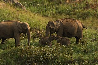
Buxa Tiger Reserve is a tiger reserve and national park in northern West Bengal, India, covering an area of 760 km2 (290 sq mi). In altitude, it ranges from 60 m (200 ft) in the Gangetic Plains to 1,750 m (5,740 ft) bordering the Himalayas in the north. At least 284 bird species inhabit the reserve. Mammals present include Asian elephant, gaur, Sambar deer, clouded leopard, Indian leopard, and Asian golden cat.

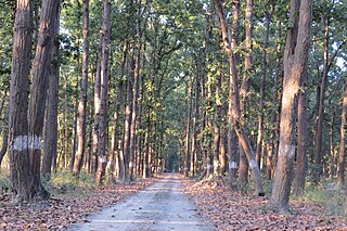
Rajaji National Park is a national park and tiger reserve in the Indian state of Uttarakhand. that encompasses the Shivaliks, near the foothills of the Himalayas. It covers 820 km2 (320 sq mi) and includes three districts of Uttarakhand—Haridwar, Dehradun and Pauri Garhwal. In 1983, three wildlife sanctuaries in the area were merged into one.

<span class="mw-page-title-main">Nagarhole National Park</span> National park in Karnataka, India

Nagarahole National Park is a national park located in Kodagu district and Mysore district in Karnataka, India.

<span class="mw-page-title-main">Upper Gangetic Plains moist deciduous forests</span> Ecoregion in northern India

The Upper Gangetic Plains moist deciduous forests is a tropical and subtropical moist broadleaf forests ecoregion of northern India.

<span class="mw-page-title-main">Ramnagar, Nainital</span> Town in Uttarakhand, India

Ramnagar is a town and municipal board in the Nainital district of Kumaon, India. It is located approximately 65 kilometres (40 mi) from Nainital, the headquarters of the district.

Evelyn Arthur Smythies, CIE, was a distinguished forester and philatelist, born of British parents in India. Smythies was an expert on the ecology of Uttarakhand and Nepal. His careful studies of the earliest postage stamps of India, Jammu and Kashmir, Nepal, and Canada produced groundbreaking handbooks on which philatelists rely, even today.

<span class="mw-page-title-main">Pilibhit Tiger Reserve</span> Tiger reserve Area in Uttar Pradesh, India

Pilibhit Tiger Reserve is located in Pilibhit district of Uttar Pradesh and was notified as a tiger reserve in 2014. It forms part of the Terai Arc Landscape in the upper Gangetic Plain along the India-Nepal border. The habitat is characterized by sal forests, tall grasslands and swamp maintained by periodic flooding from rivers. The Sharda Sagar Dam extending up to a length of 22 km (14 mi) is on the boundary of the reserve.

<span class="mw-page-title-main">Shuklaphanta National Park</span>

Shuklaphanta National Park is a national park in the Terai of the Far-Western Region, Nepal, covering 305 km2 (118 sq mi) of open grasslands, forests, riverbeds and wetlands at an elevation of 174 to 1,386 m. It is bounded by the Mahakali river in the west and south. A small part extends north of the Mahendra Highway to create a wildlife corridor for seasonal migration of wildlife into the Sivalik Hills. It was gazetted in 1976 as Royal Shuklaphanta Wildlife Reserve and was enlarged to its present size in the late 1980s. A buffer zone of 243.5 km2 (94.0 sq mi) was added in 2004. It receives a mean annual rainfall of 1,579 mm (62.2 in) and harbours 700 floral, 456 bird, 56 reptile and 15 amphibian species.

<span class="mw-page-title-main">Sathyamangalam Tiger Reserve</span> Tiger Reserve in Tamil Nadu, India

Sathyamangalam Tiger Reserve is a protected area and tiger reserve located along the area straddling both the Western Ghats and Eastern Ghats in the Erode District of the Indian state of Tamil Nadu. The Sathyamangalam Forest Division is part of the Bramhagiri-Nilgiris-Eastern Ghats Elephant Reserve notified in 2003. In 2008, part of the Sathyamangalam Forest Division was declared a wildlife sanctuary and enlarged in 2011, it covers a forest area of 1,411.6 km2 (545.0 sq mi). It is the largest wildlife sanctuary in Tamil Nadu. In 2013, an area of 1,408.6 km2 (543.9 sq mi) of the erstwhile sanctuary was notified as a tiger reserve. It was the fourth tiger reserve established in Tamil Nadu as a part of Project Tiger and is the third largest in the state.

Nandhaur Wildlife Sanctuary is a wildlife sanctuary in Uttarakhand, India that was created in 2012. It is located in the Terai Arc Landscape, a forest zone that stretches from Uttarakhand in India and extends into Nepal.

Pench National Park is a national park in India's Madhya Pradesh state, established in 1975 with an area of 257.26 km2 (99.33 sq mi). It includes Pench Tiger Reserve and derives its name from the Pench River that flows through the park from north to south dividing the park into almost equal western and eastern halves, the well-forested areas of Seoni and Chhindwara districts respectively. It was declared a sanctuary in 1965, raised to the status of national park in 1975 and enlisted as a tiger reserve in 1992. In 1983 it was declared as National Park.

Sanjiv Chaturvedi is an Indian Forest Service (IFS) officer posted as Chief Conservator of Forest (Research) at Haldwani in the Nainital district of Uttarakhand. Chaturvedi was a Chief Vigilance Officer (CVO) at AIIMS, New Delhi from 2012 to 2014, and served in the government of Haryana from 2005 to 2012.

Sitabani Wildlife Reserve is a wildlife reserve in Amgarhi, located in the Nainital district of Uttarakhand, India. It is home to variety of flora and fauna, including leopards, tigers, and over 500 species of native and migrating birds throughout the year.

References

Further reading