In archaeology, excavation is the exposure, processing and recording of archaeological remains. An excavation site or "dig" is a site being studied. Such a site excavation concerns itself with a specific archaeological site or a connected series of sites, and may be conducted over as little as several weeks to over a number of years.
A feature in archaeology and especially excavation is a collection of one or more contexts representing some human non-portable activity that generally has a vertical characteristic to it in relation to site stratigraphy. Examples of features are pits, walls, and ditches. General horizontal elements in the stratigraphic sequence, such as layers, dumps, or surfaces are not referred to as features. Examples of surfaces include yards, roads, and floors. Features are distinguished from artifacts in that they cannot be separated from their location without changing their form.
Urban archaeology is a sub discipline of archaeology specialising in the material past of towns and cities where long-term human habitation has often left a rich record of the past.

In archaeology a posthole or post-hole is a cut feature used to hold a surface timber or stone. They are usually much deeper than they are wide although truncation may not make this apparent. Although the remains of the timber may survive most postholes are mainly recognisable as circular patches of darker earth when viewed in plan. Archaeologists can use their presence to plot the layout of former structures as the holes may define its corners and sides. Construction using postholes is known as earthfast or post in ground construction.

Stratigraphy is a key concept to modern archaeological theory and practice. Modern excavation techniques are based on stratigraphic principles. The concept derives from the geological use of the idea that sedimentation takes place according to uniform principles. When archaeological finds are below the surface of the ground, the identification of the context of each find is vital in enabling the archaeologist to draw conclusions about the site and about the nature and date of its occupation. It is the archaeologist's role to attempt to discover what contexts exist and how they came to be created. Archaeological stratification or sequence is the dynamic superimposition of single units of stratigraphy, or contexts.

The Harris matrix is a tool used to depict the temporal succession of archaeological contexts and thus the sequence of depositions and surfaces on a 'dry land' archaeological site, otherwise called a 'stratigraphic sequence'. The matrix reflects the relative position and stratigraphic contacts of observable stratigraphic units, or contexts. The Matrix was developed in 1973 in Winchester, England, by Dr. Edward C. Harris.

In archaeological excavation, a plan is a drawn record of features and artifacts in the horizontal plane.
The following outline is provided as an overview of and topical guide to archaeology:

Reverse stratigraphy is the result of a process whereby one sediment is unearthed by human or natural actions and moved elsewhere, whereby the latest material will be deposited on the bottom of the new sediment, and progressively earlier material will be deposited higher and higher in the stratigraphy. Such events can be triggered by rockslides, tree throws, or other events which cause the strata of a deposit to be flipped or reversed. In archeological excavations a common cause of inversions in the stratigraphy is the collapse of walls on river banks or other raised mounds where deposits which have been cut through behind the wall prior to collapse slip over the collapsed structure resulting in the structure being under the deposits that originated earlier in time. In this case care must be taken to re-context the slipped deposits so the event of slippage appears in the correct place stratigraphically in the Harris matrix. There are numerous process that can reverse the stratigraphy or more accurately redeposit it. Many rely on slope processes, however other instances where deposits containing material later than overlying deposits occur in such features as drains or hypocaust systems. In these instances a clear understanding of the direction of "UP" and site formation processes is essential. Drains or hypocaust systems often have later material deposited within them during their "use", which may be much much later than either their initial construction or indeed the construction, use and disuse of the floors above them.

The Wheeler–Kenyon method is a method of archaeological excavation. The technique draws its origins from the work of Mortimer Wheeler and Tessa Wheeler at Verulamium (1930–35), and was later refined by Kathleen Kenyon during her excavations at Jericho (1952–58). The Wheeler–Kenyon system involves digging within a series of squares that can vary in size set within a larger grid. This leaves a freestanding wall of earth—known as a "balk" that can range from 50 cm for temporary grids, and measure up to 2 m. in width for a deeper square. The Normal width of a permanent balk is 1 m.—on each side of a unit. These vertical slices of earth allow archaeologists to compare the exact provenance of a found object or feature to adjacent layers of earth ("strata"). During Kenyon's excavations at Jericho, this technique helped discern the long and complicated occupational history of the site. It was believed that this approach allowed more precise stratigraphic observations than earlier "horizontal exposure" techniques which relied on architectural and ceramic analysis.

In archaeology, a phase refers to the logical reduction of contexts recorded during excavation to nearly contemporary archaeological horizons that represent a distinct "phase" of previous land use. These often but not always will be a representation of a former land surface or occupation level and all associated features that were created into or from this point in time. A simplified description of phase would be that "a phase is a view of a given archaeological site as it would have been at time X".

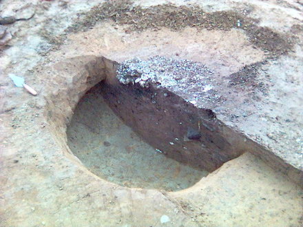
In archaeology and archaeological stratification a cut or truncation is a context that represents a moment in time when other archaeological deposits were removed for the creation of some feature such as a ditch or pit. In layman's terms, a cut can be thought of a hole that was dug in the past, though cut also applies to other parts of the archaeological record such as horizontal truncations like terraced ground. A cut context is sometimes referred to as a "negative context" as opposed to a "positive context". The term denotes that a cut has removed material from the archaeological record or natural at the time of its creation as opposed to a positive context which adds material to the archaeological record. A cut has zero thickness and no material properties of its own and is defined by the limits of other contexts. Cuts are seen in the record by virtue of the difference between the material it was cut through and the material that back fills it. This difference is seen as an "edge" by the archaeologists on site. This is shown in the picture above, where a half sectioned Saxon pit has had half its backfill removed and we can clearly see a difference between the ground the pit was cut into and the material originally filling the pit. Sometimes these differences are not clear and an archaeologist must rely on experience and insight to discover cuts.

An archaeological relationship is the position in space and by implication, in time, of an object or context with respect to another. This is determined, not by linear measurement but by determining the sequence of their deposition – which arrived before the other. The key to this is stratigraphy.

Single context recording was initially developed by Ed Harris and Patrick Ottaway in 1976, from a suggestion by Lawrence Keene. It was further developed by the Department of Urban Archaeology from where it was then exported, in the mid-1980s by Pete Clarke to the Scottish Urban Archaeological Trust and Nick Pearson to the York Archaeological Trust. It has become a popular system of recording and planning being used in many countries in Europe and in Lebanon, it is especially suited to the complexities of deep, typically urban, archaeology. Each excavated context is given a unique "context number" and is recorded by type on a context sheet and perhaps being drawn on a plan and/or a section. Depending on time constraints and importance contexts may also be photographed, but in this case a grouping of contexts and their associations are the purpose of the photography. Finds from each context are bagged and labelled with their context number and site code for later cross reference work carried out post excavation. The height above sea level of pertinent points on a context, such as the top and bottom of a wall are taken and added to plans sections and context sheets. Heights are recorded with a dumpy level or total station by relation to the site temporary benchmark. Samples of deposits from contexts are sometimes also taken, for later environmental analysis or for scientific dating.
In archaeology, natural is a term to denote a layer (stratum) in the stratigraphic record where there is no evidence of anthropogenic activity. While there may be "natural" layers interbedded with archaeologically interesting layers, such as when a site was abandoned for long periods of time between occupations by man, the top of the natural layer below which there is no anthropogenic activity on site, and thus where the archaeological record chronologically begins, is the sought-for point to terminate digging. This final natural layer is often the underlying geological makeup of the site that was formed by geological processes. It is the goal of complete excavation to remove the entirety of the archaeological record all the way to the final "natural", thus leaving only the natural deposits of pre-human activity on site. If the excavation is related to development, the impact assessment may stipulate excavation will cease at a certain depth, because the nature of the development will not disturb remains below a certain level; such an excavation may not reach a natural or sterile layer. Thus one always has to overdig a site in order to establish the natural.
In archaeology a fill is the material that has accumulated or has been deposited into a cut feature such as ditch or pit of some kind of a later date than the feature itself. Fills are an important part of the archaeological record as their formation and composition can throw light on many aspects of archaeological study.
In the field of archaeology, a spit is a unit of archaeological excavation with an arbitrarily assigned measurement of depth and extent. It is a method of excavation employed without regard to the archaeological stratigraphy that may be identifiable at the archaeological site under investigation. The method of excavating in arbitrary spits is most frequently encountered at site excavations which lack any visible or reconstructable stratigraphy in the archaeological context, or when excavating through intrusive or fill deposits.
Archaeology, or archeology, is the study of human activity through the recovery and analysis of material culture. The archaeological record consists of artifacts, architecture, biofacts or ecofacts and cultural landscapes. Archaeology can be considered both a social science and a branch of the humanities. In Europe it is often viewed as either a discipline in its own right or a sub-field of other disciplines, while in North America archaeology is a sub-field of anthropology.
Porac, Pampanga contains areas in and near Babo Balukbuk in Porac, Philippines that have strong indication of human habitation, according to investigations published on the University of the Philippines Archaeological Studies Program website. Later test excavations confirmed this conclusion through the presence of materials dated around the 12th century to the 17th century C.E.
This page is a glossary of archaeology, the study of the human past from material remains.