Speonk station

Last updated

Speonk
Speonk Station - May 2015.jpg
Speonk station in May 2015.
General information
LocationPhillips Avenue & Depot Road
Speonk, New York
Coordinates 40°49′16″N72°42′17″W / 40.821224°N 72.704853°W / 40.821224; -72.704853
Owned by Long Island Rail Road
Platforms1 side platform
Tracks1
Construction
ParkingYes (free)
Bicycle facilitiesYes
AccessibleYes
Other information
Fare zone12
History
Opened1870
Rebuilt1901, 1958, 2001
Previous namesRemsenburg (18951897)
Passengers
20122014180 [1]
Rank108 of 125
Services
Preceding station MTA NYC logo.svg Long Island Rail Road Following station
Mastic–Shirley Montauk Branch
limited service
Westhampton
toward Montauk
Former services
Preceding station Long Island
Rail Road
Following station
Eastport Montauk Division Westhampton
toward Montauk
Eastport
toward Manorville
Sag Harbor Branch Westhampton
toward Sag Harbor
Location
Speonk station

Speonk is an unmanned railroad station on the Montauk Branch of the Long Island Rail Road. It is located on Phillips Avenue at Depot Road in Speonk, New York, just north of Montauk Highway (CR 80). The station has two parking lots, one operated by the Long Island Rail Road, and the other operated by the Town of Southampton, both of which are free. It also lies adjacent to one of the largest railroad yards on Long Island's East End. This yard is mostly used to hold passenger consists, as a handful of trains terminate at Speonk rather than continue all the way to Montauk.

Contents

History

The Speonk Trackside Cafe, which operates out of the former station house. Speonk Trackside Cafe.JPG
The Speonk Trackside Cafe, which operates out of the former station house.
Speonk Yard, just east of the station Speonk Yard.jpg
Speonk Yard, just east of the station

Speonk station was originally built in February 1870 along what was then the Sag Harbor Branch. From 1895 to 1897 it was known as "Remsenburg station", acknowledging the hamlet of Remsenburg, New York, which lies just south of Speonk. The station was struck by lightning and burned on June 22, 1901, [2] and a second depot opened in December 1901. Railroad conductors frequently accentuated the name when calling it out as the next station. This latter agency and depot were closed in 1958, and the station has been unmanned ever since. The former station was converted into a snack bar that is still operating as Little Gull cafe. [3]

When Eastport and East Moriches stations were closed by the LIRR on October 6, 1958, due to lack of usage, commuters were told to transfer either to this station or to Center Moriches station. The elimination of the latter on March 16, 1998, makes Speonk the next choice for commuters east of Mastic–Shirley station, almost ten miles away by road. The traffic from all three intervening stations which have been eliminated since 1950 has been transferred to these two stations. [4]

As part of its program to upgrade all stations to high-level platforms, the LIRR relocated the functional portion of Speonk station between 1996 and 1997. A new platform was built on the west side of North Phillips Avenue, along with a new parking lot; the aforementioned station house and former low-level platform were located to the east. The new platform includes an outdoor enclosure, but no new station building was constructed. The new station includes ticket vending machines and elegant lighting in the parking lots. The former station house and current cafe is across the tracks from the yard.

The yard east of the station features a wye to turn locomotives around.

Station layout

The station has one four-car-long high-level platform on the south side of the single track. There are two large parking lots nearby.

Track 1      Montauk Branch limited service toward Long Island City or Penn Station (Mastic–Shirley)
      Montauk Branch limited service toward Montauk (Westhampton)
Side platform, doors will open on the left or right Wheelchair symbol.svg

Related Research Articles

<span class="mw-page-title-main">Long Island Rail Road</span> Commuter rail system on Long Island, New York

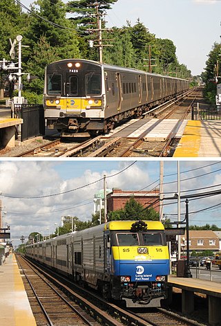
The Long Island Rail Road, often abbreviated as the LIRR, is a railroad in the southeastern part of the U.S. state of New York, stretching from Manhattan to the eastern tip of Suffolk County on Long Island. The railroad currently operates a public commuter rail service, with its freight operations contracted to the New York and Atlantic Railway. With an average weekday ridership of 354,800 passengers in 2016, it is the busiest commuter railroad in North America. It is also one of the world's few commuter systems that runs 24/7 year-round. It is publicly owned by the Metropolitan Transportation Authority, which refers to it as MTA Long Island Rail Road. In 2023, the system had a ridership of 75,186,900, or about 253,800 per weekday as of the fourth quarter of 2023.

<span class="mw-page-title-main">Atlantic Terminal</span> Long Island Rail Road station in Brooklyn, New York

The Atlantic Terminal is the westernmost commuter rail terminal on the Long Island Rail Road's (LIRR) Atlantic Branch, located at Flatbush Avenue and Atlantic Avenue in Downtown Brooklyn, New York City. It is the primary terminal for the West Hempstead Branch, and a peak-hour terminal for some trains on the Hempstead Branch, Far Rockaway Branch, and the Babylon Branch; most other service is provided by frequent shuttles to Jamaica station. The terminal is located in the City Terminal Zone, the LIRR's Zone 1, and thus part of the CityTicket program.

<span class="mw-page-title-main">Mastic–Shirley station</span> Long Island Rail Road station in Suffolk County, New York

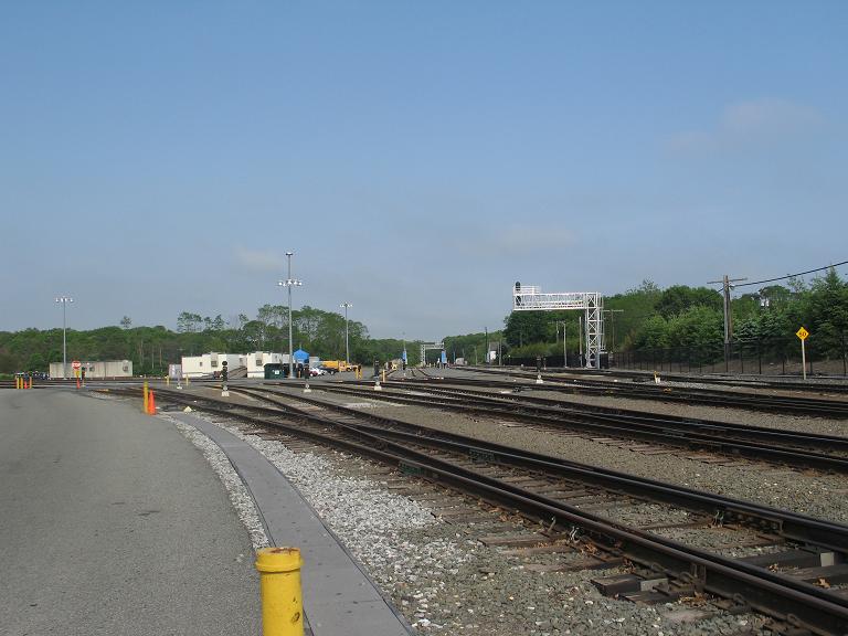
The Mastic–Shirley station is a station on the Long Island Rail Road's Montauk Branch in Shirley, New York. This station is reached via William Floyd Parkway. The station has two ticket machines.

<span class="mw-page-title-main">Port Washington station</span> Long Island Rail Road station in Nassau County, New York

Port Washington is the terminus of the Long Island Rail Road's Port Washington Branch in Port Washington, New York. The station is located on Main Street, between Haven Avenue and South Bayles Avenue, just west of Port Washington Boulevard, and is 19.9 miles (32 km) from Pennsylvania Station in Midtown Manhattan. A pedestrian bridge exists between the platforms, and is in line with Franklin Avenue, ending at Haven Avenue.

<span class="mw-page-title-main">Montauk Branch</span> Long Island Rail Road branch

The Montauk Branch is a rail line owned and operated by the Long Island Rail Road in the U.S. state of New York. The line runs the length of Long Island, 115 miles (185 km) from Long Island City to Montauk. However, in LIRR maps and schedules for public use, the term Montauk Branch refers to the line east of Babylon; service from Jamaica to Babylon is covered by separate Babylon Branch schedules, while the line west of Jamaica is currently unused for passenger service. A select number of Montauk Branch trains operate via the Main Line during peak hours.

<span class="mw-page-title-main">Westbury station (LIRR)</span> Long Island Rail Road station in Nassau County, New York

Westbury is a station on the Long Island Rail Road's Main Line. All trains for the Port Jefferson Branch and Ronkonkoma Branch run through it, though only some trains on the Port Jefferson branch stop. It is located at Union and Post Avenues in Westbury, New York. It is 23.4 miles (37.7 km) from Penn Station. The station is fully wheelchair accessible. It has two side platforms and three tracks.

<span class="mw-page-title-main">Medford station</span> Long Island Rail Road station in Suffolk County, New York

Medford is a station in the hamlet of Medford, New York on the Main Line of the Long Island Rail Road. Medford is located on New York State Route 112 between Peconic Avenue and Long Island Avenue. Access to the station is available from a narrow curving roadway leading off Route 112. This roadway used to connected with the Ohio Avenue intersection until Ohio Avenue was closed north of Peconic Avenue in 2007. It is also accessible from the north end of Oregon Avenue, although the Medford Fire Department periodically closes the Oregon Avenue access road for drills or other exercises.

<span class="mw-page-title-main">Sayville station</span> Long Island Rail Road station in Suffolk County, New York

Sayville is a station on the Montauk Branch of the Long Island Rail Road in the village of Sayville, New York, on Depot Street between Greeley Avenue and Railroad Avenue. Ferries to Fire Island board from a port south of the station.

<span class="mw-page-title-main">St. James station (LIRR)</span> Long Island Rail Road station in Suffolk County, New York

St. James is a station and historic landmark on the Port Jefferson Branch of the Long Island Rail Road. The station is located on Lake Avenue and Railroad Avenue, just south of New York State Route 25A in St. James, Suffolk County, New York.

<span class="mw-page-title-main">Ronkonkoma station</span> Long Island Rail Road station in Suffolk County, New York

Ronkonkoma is a major railroad station and transportation hub along the Main Line of the Long Island Rail Road in Ronkonkoma, New York. The station is the eastern terminus of the Ronkonkoma Branch and the western terminus of the Greenport Branch.

<span class="mw-page-title-main">Central Islip station</span> Long Island Rail Road station in Suffolk County, New York

Central Islip is a station on the Main Line of the Long Island Rail Road. It is at the southwest corner of Suffolk County Road 100 and Lowell Avenue in Central Islip, New York. Short-term parking is also available on Suffolk CR 100 across from the intersections between Pineville and Hawthorne Avenues.

<span class="mw-page-title-main">Long Beach station (LIRR)</span> Long Island Rail Road station in Nassau County, New York

The Long Beach station is an intermodal center and the terminus of the Long Beach Branch of the Long Island Rail Road. It is located at Park Place and Park Avenue in the City of Long Beach, New York, serving as the city's major transportation hub.

<span class="mw-page-title-main">Montauk station</span> Long Island Rail Road station in Suffolk County, New York

Montauk is the terminus of the Montauk Branch of the Long Island Rail Road, as well as the easternmost railroad station on Long Island and in New York state. The station is located on Edgemere Street and Fort Pond Road west of Montauk Harbor, New York.

<span class="mw-page-title-main">Islip station (LIRR)</span> Long Island Rail Road station in Suffolk County, New York

Islip is a station on the Montauk Branch of the Long Island Rail Road, off NY 111 and Nassau Avenue, north of Suffolk CR 50, and south of Moffitt Boulevard in Islip, New York.

<span class="mw-page-title-main">Bay Shore station</span> Long Island Rail Road station in Suffolk County, New York

Bay Shore is a major railroad station on the Montauk Branch of the Long Island Rail Road (LIRR), on Park Avenue and Oak Street north of Suffolk CR 50 and west of Fourth Avenue, in Bay Shore, New York. Ferries to Fire Island board from a port south of the station.

<span class="mw-page-title-main">Oakdale station</span> Long Island Rail Road station in Suffolk County, New York

Oakdale is a railroad station on the Montauk Branch of the Long Island Rail Road, on the corner of Oakdale-Bohemia Road and Montauk Boulevard in view of Montauk Highway across Norman DeMott Park, in Oakdale, New York.

<span class="mw-page-title-main">Eastport station</span>

Eastport was a railroad station built on the former Manorville Branch of the Long Island Rail Road in Eastport, New York. It was opened in 1870 and closed in 1958. It was the easternmost station along both branches in the Town of Brookhaven.

<span class="mw-page-title-main">Bushwick Branch</span> Long Island Rail Road freight branch in New York City

The Bushwick Branch, also called the Bushwick Lead Track, is a freight railroad branch in New York City. It runs from the East Williamsburg neighborhood of Brooklyn to Fresh Pond Junction in the Glendale neighborhood of Queens, where it connects with the Montauk Branch of the Long Island Rail Road. It is owned by the LIRR but operated under lease by the New York and Atlantic Railway, which took over LIRR freight operations in May 1997.

<span class="mw-page-title-main">Center Moriches station</span>

Center Moriches was a station stop along the Montauk Branch of the Long Island Rail Road. It was located on Railroad Avenue and Hamilton Street in Center Moriches, New York.

<span class="mw-page-title-main">East Moriches station</span>

East Moriches is a former railroad station on the Montauk Branch of the Long Island Rail Road. It was located near Pine Street and Railroad Avenue in East Moriches, New York.

References

  1. "2012-2014 LIRR Origin and Destination Report : Volume I: Travel Behavior Among All LIRR Passengers" (PDF). Metropolitan Transportation Authority. August 23, 2016. PDF pp. 15, 199. Archived (PDF) from the original on July 17, 2019. Retrieved March 29, 2020. Data collection took place after the pretest determinations, starting in September 2012 and concluding in May 2014. .... 2012-2014 LIRR O[rigin and ]D[estination] COUNTS: WEEKDAY East/West Total By Station in Numerical Order ... Speonk
  2. ""A History of the Speonk Station," by George Wybenga" (PDF). The Postboy; The official publication of the Railroad Museum of Long Island (Summer 2010).
  3. "LIRR Trackside Business". TrainsAreFun.com.
  4. Stadler, Derek. "Discontinued Station Stops: The History of the Moriches and the Termination of Railroad Service". derekstadler.wordpress.com. Archived from the original on October 8, 2021. Retrieved July 10, 2022.