Richmond Hill station (LIRR)

Last updated

Richmond Hill
Richmond Hill LIRR Station Canopy.jpg
The abandoned station canopy viewed in October 2020.
General information
Location Hillside Avenue and Babbage Street
Richmond Hill, Queens, New York
Coordinates 40°42′02″N73°49′56″W / 40.70056°N 73.83222°W / 40.70056; -73.83222
Owned by Long Island Rail Road
Line(s) Montauk Branch
Platforms1 island platform
Tracks2
History
Opened1869
ClosedMarch 16, 1998
Rebuilt1923
ElectrifiedAugust 29, 1905
Previous namesClarenceville (1869–1871)
Former services
Preceding station MTA NYC logo.svg Long Island Rail Road Following station
Ridgewood Montauk Branch Dunton
toward Montauk
Location
Richmond Hill station (LIRR)

The Richmond Hill station is a closed station on the Montauk Branch of the Long Island Rail Road in the Richmond Hill neighborhood of Queens in New York City. The station is located at Myrtle Avenue and cuts diagonally from the intersection of Jamaica Avenue and Lefferts Boulevard through to Hillside Avenue. The station has two tracks and an island platform. Richmond Hill was the only station on the Lower Montauk Branch that was elevated with a high-level platform for passengers to wait for trains; the others were at ground level, with low-level platforms.

Contents

The Richmond Hill station was originally built by the South Side Railroad of Long Island in 1869 as the Clarenceville station. After New York City and the Long Island Rail Road began negotiating the elimination of numerous at-grade crossings within Queens in the 1910s, the current station was opened on a viaduct in 1923. The station was closed on March 16, 1998, along with nine others due to low ridership and the potential cost of upgrading the stations to modern standards; at the time of its closure, the station averaged one passenger per day.

History

Richmond Hill station on an 1891 map LIRR 1891 Richmond Hill station.jpg
Richmond Hill station on an 1891 map

Richmond Hill station was originally built by the South Side Railroad of Long Island in 1869 as the Clarenceville station, [1] [2] distinct from the nearby Clarenceville station on the Atlantic Branch. Clarenceville was a farming community centered around Jamaica and Greenwood Avenues (the latter now 111th Street, where the Atlantic Branch station was located), which is now part of Richmond Hill. [3] The Richmond Hill neighborhood was founded in 1868, with the purchase of the Lefferts and Welling farms by Albon Platt Man. [3] [4] The station name was changed to Richmond Hill in November 1871. [1] It had two tracks with a station house on one side and an enclosed wooden shelter on the other. [1]

In 1911, New York City and the Long Island Rail Road began negotiating the elimination of numerous at-grade crossings within Queens. [5] [6] In 1917, the LIRR finalized the grade crossing elimination project plans for the Montauk Branch in the Richmond Hill area, which would construct a new elevated station between Park Street (today's Hillside Avenue) and Lefferts Avenue (now Lefferts Boulevard). [7] During the project, the wooden station was temporarily relocated. [6] The current station opened in 1923. [1] The project eliminated numerous at-grade crossings in the vicinity of the station, including those at St. Anne Avenue (now 84th Avenue), Ashland Avenue (now 85th Avenue), Park Street, the intersection of Jamaica and Lefferts Avenue, and Ridgewood Avenue (now 89th Avenue). It also extended the roads adjacent to the right-of-way then known as Railroad Avenue (now Babbage Street and Bessemer Street) east to Lefferts Avenue. [5] [7] [8]

The station was closed on March 16, 1998, along with nine others, including the other four on the Lower Montauk branch, due to low ridership and the potential cost of upgrading the stations to modern standards. [9] This station and Penny Bridge, also on the Lower Montauk, averaged one daily rider each at the time of their closure. [9] The station and platform remain, though access via the staircase at Jamaica Avenue is gated off. [10] [11] [12] Shortly after the station's closure, it was frequented by the homeless and animals, and was used as an illegal waste dumping site. [11] [13] [14] In July 2003, new security fencing was installed around the trestle, [10] [13] though maintenance problems and trespassing issues have continued. [14]

Station layout

The station is located on a massive concrete viaduct Richmond Hill LIRR from Hillside Ave-1.jpg
The station is located on a massive concrete viaduct
3F BMT Jamaica Line
2F
Platform level
WestboundNo passenger service
Island platform, not in use
EastboundNo passenger service
GStreet level-

The station has two tracks and an island platform. Richmond Hill was the only station on the Lower Montauk Branch that was elevated with a high-level platform for passengers to wait for trains (the other four stations only had strips of pavement beside the tracks, requiring passengers to wait on track level and climb aboard trains). [15] [16] The station sits on a concrete trestle, supported by pairs of concrete arches. [7] [12] [17] The station's island platform has a small shelter in the center, and two stairways down to the street. One staircase goes down from the shelter to Hillside Avenue. The other is at the south (railroad east) end that goes down to the three-way intersection of Myrtle Avenue, Lefferts Boulevard and Jamaica Avenue. The southern staircase is blocked by a security gate. [7] [12] [15] The platform could accommodate trains of six 85-foot (26 m) cars. [16]

Most of the space underneath the trestle between Lefferts Boulevard and Hillside Avenue is gated off by green fencing, installed in 2003. [13] The area has been used as parking space in the past. [10] [11] [13]

The Jamaica elevated (serving the New York City Subway's J and Z trains) runs above the Montauk Branch tracks along Jamaica Avenue. This section of the elevated was opened in 1917 by the Brooklyn–Manhattan Transit Corporation (BMT), built after the LIRR station. [18] The closest station is two blocks east at 121st Street. [19]

Related Research Articles

<span class="mw-page-title-main">Long Island Rail Road</span> Commuter rail system on Long Island, New York

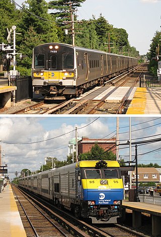
The Long Island Rail Road, often abbreviated as the LIRR, is a railroad in the southeastern part of the U.S. state of New York, stretching from Manhattan to the eastern tip of Suffolk County on Long Island. The railroad currently operates a public commuter rail service, with its freight operations contracted to the New York and Atlantic Railway. With an average weekday ridership of 354,800 passengers in 2016, it is the busiest commuter railroad in North America. It is also one of the world's few commuter systems that runs 24/7 year-round. It is publicly owned by the Metropolitan Transportation Authority, which refers to it as MTA Long Island Rail Road. In 2023, the system had a ridership of 75,186,900, or about 253,800 per weekday as of the fourth quarter of 2023.

<span class="mw-page-title-main">Richmond Hill, Queens</span> Neighborhood in New York City

Richmond Hill is a commercial and residential neighborhood located in the southeastern section of the New York City borough of Queens. The area borders Kew Gardens and Forest Park to the north, Jamaica and South Jamaica to the east, South Ozone Park to the south, and Woodhaven and Ozone Park to the west. The neighborhood is split between Queens Community Board 9 and 10.

<span class="mw-page-title-main">Atlantic Branch</span> Long Island Rail Road branch

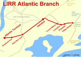
The Atlantic Branch is an electrified rail line owned and operated by the Long Island Rail Road in the U.S. state of New York. It is the only LIRR line with revenue passenger service in the borough of Brooklyn.

<span class="mw-page-title-main">Morris Park Facility</span> Railroad maintenance facility in Queens, New York

The Morris Park Facility is a maintenance facility of the Long Island Rail Road in Queens, New York City. It includes two employee-only side platforms on the Atlantic Branch named Boland's Landing. Two wooden platforms, each two cars long, exist on the two-track line, with a flashlight for workers to signal trains to stop.

<span class="mw-page-title-main">City Terminal Zone</span> Collection of Long Island Rail Road branches

The City Terminal Zone is the set of Long Island Rail Road lines within New York City west of Jamaica station, except the Port Washington Branch.

<span class="mw-page-title-main">Babylon Branch</span> Long Island Rail Road branch

The Babylon Branch is a rail service operated by the Long Island Rail Road in the U.S. state of New York. The term refers to the trains serving Montauk Branch stations from Valley Stream east to Babylon; in other words, the Babylon Branch is a rail service rather than an actual track. The electrification of the Montauk Branch ends east of the Babylon station, so the Babylon Branch is mostly served by electric trains.

<span class="mw-page-title-main">Montauk Branch</span> Long Island Rail Road branch

The Montauk Branch is a rail line owned and operated by the Long Island Rail Road in the U.S. state of New York. The line runs the length of Long Island, 115 miles (185 km) from Long Island City to Montauk. However, in LIRR maps and schedules for public use, the term Montauk Branch refers to the line east of Babylon; service from Jamaica to Babylon is covered by separate Babylon Branch schedules, while the line west of Jamaica is currently unused for passenger service. A select number of Montauk Branch trains operate via the Main Line during peak hours.

<span class="mw-page-title-main">Kew Gardens station (LIRR)</span> Long Island Rail Road station in Queens, New York

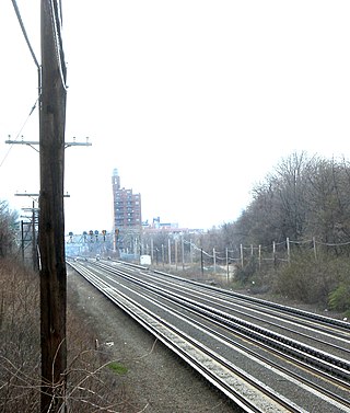
The Kew Gardens station is a station on the Main Line of the Long Island Rail Road (LIRR). It is located in the Kew Gardens neighborhood of Queens, New York City, near Austin Street and Lefferts Boulevard. The station is located within the City Terminal Zone, part of LIRR fare zone 1. It contains four tracks and two side platforms for the outermost tracks.

<span class="mw-page-title-main">Main Line (Long Island Rail Road)</span> Long Island Rail Road branch

The Main Line is a rail line owned and operated by the Long Island Rail Road in the U.S. state of New York. It begins as a two-track line at Long Island City station in Long Island City, Queens, and runs along the middle of Long Island about 95 miles (153 km) to Greenport station in Greenport, Suffolk County. At Harold Interlocking approximately one mile east of Long Island City, the tracks from the East River Tunnels and 63rd Street Tunnel into Manhattan intersect with the Main Line, which most trains use rather than using the Long Island City station.

The Long Island Rail Road is a railroad owned by the Metropolitan Transportation Authority in the U.S. state of New York. It is the oldest United States railroad still operating under its original name and charter. It consolidated several other companies in the late 19th century. The Pennsylvania Railroad owned the Long Island Rail Road for the majority of the 20th century and sold it to the State in 1966.

<span class="mw-page-title-main">Dunton station</span> Former railroad station in New York City

Dunton was a ground-level station on the Long Island Rail Road's Montauk Branch, Atlantic Branch, and later the Main Line in Dunton, Queens, New York City, United States. It was closed in 1939 when the Atlantic Branch was placed in a tunnel east of East New York.

<span class="mw-page-title-main">Rockaway Beach Branch</span> Former Long Island Rail Road branch (closed 1962)

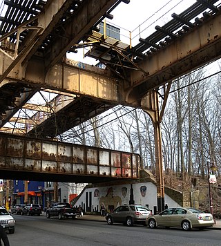
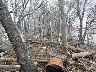
The Rockaway Beach Branch was a rail line owned and operated by the Long Island Rail Road in Queens, New York City, United States. The line left the Main Line at Whitepot Junction in Rego Park heading south via Ozone Park and across Jamaica Bay to Hammels in the Rockaways, turning west there to a terminal at Rockaway Park. Along the way it connected with the Montauk Branch near Glendale, the Atlantic Branch near Woodhaven, and the Far Rockaway Branch at Hammels.

<span class="mw-page-title-main">Rego Park station (LIRR)</span> Former railroad station in New York City

Rego Park is a former Long Island Rail Road station. It was made of wood, unlike most other stations that were concrete. The station opened in May 1928 with two side platforms outside the two Rockaway Beach Branch tracks that bracketed the four-track Main Line, so only Rockaway trains stopped there. After the Rockaway Trestle fire in 1950, the line was closed station by station. The station closed on June 8, 1962, one day before the Rockaway Beach Branch was abandoned. Nothing remains at the site today.

<span class="mw-page-title-main">Brooklyn Manor station</span> Former railroad station in New York City

The Brooklyn Manor station was a station on the Long Island Rail Road's Rockaway Beach Branch located on the south side of Jamaica Avenue at 100th Street, straddling the border between Richmond Hill and Woodhaven in Queens, New York City. The station name referred to the nearby Brooklyn Manor section of Woodhaven, originally a 603-lot development bounded by Woodhaven Boulevard to the west, 96th/98th Streets to the east, Forest Park to the north, and Jamaica Avenue to the south. The station opened in January 1911, and was constructed as a replacement for the Brooklyn Hills station, which was located 3,000 feet (910 m) to the north. This station closed along with the rest of the Rockaway Beach Branch in 1962, and was subsequently demolished.

<span class="mw-page-title-main">Clarenceville station (LIRR)</span>

The Clarenceville station was on the Atlantic Branch of the Long Island Rail Road, located on Atlantic Avenue west of 111th Street in the Richmond Hill section of Queens, New York City. Richmond Hill station to the north, at Jamaica Avenue and Lefferts Boulevard, was also originally named Clarenceville Station when it opened in 1868, but that name was changed in 1871.

<span class="mw-page-title-main">Parkside station</span> Former railroad station in New York City

Parkside is a former elevated Long Island Rail Road (LIRR) station on the north side of Metropolitan Avenue on the border of the Rego Park, Forest Hills, and Glendale neighborhoods in Queens, New York City. Opened in 1927, the wooden station was part of the Rockaway Beach Branch and was the northernmost station on the branch before the junction with the Main Line at Rego Park Station and the terminus of the line at Grand Street station in Elmhurst. It also had a connecting spur to the Montauk Branch east towards Richmond Hill station. The station was closed in 1962, twelve years after the LIRR had abandoned the Rockaway portions of the line.

Central Railroad of Long Island was built on Long Island, New York, by Alexander Turney Stewart, who was also the founder of Garden City. The railroad was established in 1871, then merged with the Flushing and North Side Railroad in 1874 to form the Flushing, North Shore and Central Railroad. It was finally acquired by the Long Island Rail Road in 1876 and divided into separate branches. Despite its short existence, the CRRLI had a major impact on railroading and development on Long Island.

Higbie Avenue was a railroad station along the Atlantic Branch of the Long Island Rail Road, in Queens, New York City. The station was located on 140th Avenue and Edgewood Avenue in the Springfield section of Queens, New York City between Locust Manor and Laurelton stations.

Richmond Hill Historic District is a national historic district in Richmond Hill, Queens, New York. It is bounded to the north by Park Lane South, to the east by 118th Street, to the south by Myrtle Avenue. The district includes 200 contributing buildings built between 1890 and 1915 next to the former South Side Railroad line and the Richmond Hill station at Hillside Avenue, shaped roughly like a triangle. They consist mainly of architectural styles dating back to an earlier time of Academic Eclecticism in home building and were constructed for railroad commuters. Most of the contributing properties were planned as suburbs to Brooklyn and Manhattan. It also included smaller houses built between 1917 and 1930 at the beginning of the Great Depression.

References

  1. 1 2 3 4 David D. Morrison; Valerie Pakaluk (2003). Long Island Rail Road Stations. Arcadia Publishing. pp. 40–41. ISBN   978-0-7385-1180-1.
  2. See:
  3. 1 2 Orman, John (October 27, 1972). "Historical Notes on Richmond Hill". Leader-Observer. Fultonhistory.com . Retrieved August 21, 2016.
  4. Carl Ballenas (2011). Jamaica. Arcadia Publishing. pp. 102, 105. ISBN   978-0-7385-7426-4 . Retrieved August 21, 2016.
  5. 1 2 "Remove Grade Crossings; The City of New York and the Long Island Railroad Execute a Contract to Spend Two Millions; The City Will Pay $575,000". The Daily Long Island Farmer. Fultonhistory.com. July 29, 1911. p. 1. Retrieved August 21, 2016.
  6. 1 2 "One Crossing Is Going". Leader-Observer. Fultonhistory.com. March 1, 1923. p. 1. Retrieved August 21, 2016.
  7. 1 2 3 4 "To Elevate L.I. Tracks at Richmond Hill: Company Promises To Soon Eliminate Grade Crossings; System May Be Electrified". Leader-Observer. Fultonhistory.com. February 22, 1917. p. 8. Retrieved August 21, 2016.
  8. See:
  9. 1 2 Sengupta, Somini (March 15, 1998). "End of the Line for L.I.R.R.'s 10 Loneliest Stops". The New York Times. Retrieved August 7, 2009.
  10. 1 2 3 Simon, David (January 30, 2003). "Rundown Rich. Hill LIRR Station To Receive $75,000 Overhaul". Queens Chronicle. Retrieved August 21, 2016.
  11. 1 2 3 Davidson, Alex (October 17, 2002). "Abandoned railroad station mars face of Richmond Hill". Times Ledger. Retrieved August 21, 2016.
  12. 1 2 3 Walsh, Kevin (March 7, 2010). "MYRTLE AVENUE Part 4, Glendale, Forest Park, Richmond Hill". Forgotten New York. Retrieved August 21, 2016.
  13. 1 2 3 4 See:
  14. 1 2 See:
  15. 1 2 Walsh, Kevin (April 2000). "LONG ISLAND RAIL ROAD RETIRED FLEET". Forgotten New York. Retrieved August 21, 2016.
  16. 1 2 Queens Subway Options Study, New York: Environmental Impact Statement. United States Department of Transportation, Metropolitan Transportation Authority, Urban Mass Transit Administration. May 1984. Retrieved July 10, 2016.
  17. Cohen, Joyce (April 13, 1997). "Working-Class, With Touch of Nostalgia". The New York Times . Retrieved August 21, 2016.
  18. See:
  19. "MTA Neighborhood Maps: neighborhood". Metropolitan Transportation Authority. 2018. Retrieved October 1, 2018.