Jamaica Avenue

Last updated
Template:Attached KML/Jamaica Avenue
KML is from Wikidata
Jamaica Avenue
NY-25.svg
New York State Route 25
JamAvenueGuyBrBlvd.jpg
Jamaica Avenue at Guy R. Brewer Boulevard
Maintained by NYCDOT
Length10.8 mi (17.4 km) [1]
Component
highways
NY-25.svg NY 25 in Bellerose Manor
West end Fulton Street  / East New York Avenue in East New York
Major
junctions
Jackie Robinson Pkwy Shield free.svg Jackie Robinson Parkway in Cypress Hills
I-678.svg I-678 in Jamaica
Cross Island Pkwy Shield free.svgNY-25.svg Cross Island Parkway  / NY 25 in Queens Village
East endNY-25.svg NY 25 (Jericho Turnpike) in Floral Park
East New York bus depot on Jamaica Avenue Enybusdepotjeh.JPG
East New York bus depot on Jamaica Avenue
Chase Bank at 161st St and Jamaica Avenue Chase Bank Jamaica Ave jeh.jpg
Chase Bank at 161st St and Jamaica Avenue

Jamaica Avenue is a major avenue in the New York City boroughs of Brooklyn and Queens, New York, in the United States. Jamaica Avenue's western end is at Broadway and Fulton Street, as a continuation of East New York Avenue, in Brooklyn's East New York neighborhood. Physically, East New York Avenue connects westbound to New York Avenue, where East New York Avenue changes names another time to Lincoln Road; Lincoln Road continues to Ocean Avenue in the west, where it ends. Its eastern end is at the city line in Bellerose, Queens, where it becomes Jericho Turnpike to serve the rest of Long Island. The section of Jamaica Avenue designated as New York State Route 25 runs from Braddock Avenue to the city line, where Jamaica Avenue becomes Jericho Turnpike.

Contents

History

Jamaica Avenue was part of a pre-Columbian trail for tribes from as far away as the Ohio River and the Great Lakes, coming to trade skins and furs for wampum. It was in 1655 that the first settlers paid the Native Americans with two guns, a coat, and some powder and lead, for the land lying between the old trail and "Beaver Pond", later Baisley Pond. Dutch Director-General Peter Stuyvesant dubbed the area "Rustdorp" in granting the 1656 land patent. The English, who took control of the colony in 1664, renamed the little settlement "Jameco", for the Jameco (or Yamecah) Native Americans.

During the early 19th century, the old road through Jamaica Pass was the Brooklyn Ferry Road; at mid-century this became the Brooklyn and Jamaica Plank Road, with toll booths. [2] Late in the century the portion west of Jamaica Pass became Fulton Street, and the eastern portion Jamaica Avenue.

Commerce

The part of Jamaica Avenue that runs through Jamaica, Queens is an important shopping street, and is on par with Brooklyn's Fulton Street. Prices are said to be low, in an exciting market place atmosphere. It is also the historic center of the former village with several city landmarks including the King Manor.

Jamaica Avenue is also the main shopping street for many other neighborhoods it runs through as well, including Woodhaven, Richmond Hill, and Queens Village.

Transportation

Jamaica Avenue is the starting point of many newer streets in Queens, such as Hempstead Avenue, Guy R. Brewer Boulevard, Farmers Boulevard, and Queens Boulevard. Many bus lines run down Jamaica Avenue, most notably the Q56, [3] Q110, [4] and Q36. [5] The New York City Subway's BMT Jamaica Line ( J and Z trains) runs above Jamaica Avenue through the Cypress Hills section of Brooklyn along with Woodhaven and Richmond Hill. The Jamaica Bus Depot and East New York Bus Depot are located near the avenue.

In June 2020, mayor Bill de Blasio announced that the city would test out busways on Jamaica Avenue from Sutphin Boulevard to 168th Street, a distance of about 0.9 miles (1.4 km), in downtown Jamaica. [6] [7] Despite a deadline of October 2020, the Jamaica Avenue busway was not in place at that time. [8] [9] Furthermore, transportation advocates did support a bus lane in downtown Jamaica, but they preferred a bus lane on the busier Archer Avenue corridor, which parallels Jamaica Avenue to the south. [10]

Jamaica Avenue intersects with other former country roads in Queens which have become important urban streets, including Woodhaven Boulevard, Myrtle Avenue, Lefferts Boulevard, Metropolitan Avenue, Sutphin Boulevard, Parsons Boulevard, Francis Lewis Boulevard, and Springfield Boulevard. Jamaica Avenue, from Alabama Avenue in East New York, Brooklyn to the Nassau County line, is 10.9 miles (17.5 km) long. [1]

The Jamaica Center–Parsons/Archer station ( E , J , and Z trains) with its associated bus station is a major transport hub, a rival to the nearby Jamaica–179th Street station ( F and <F> trains) on Hillside Avenue.

Major intersections

CountyLocationmi [1] kmDestinationsNotes
Brooklyn East New York 0.00.0 Fulton Street / Broadway / East New York Avenue westContinues west
0.20.32 Pennsylvania Avenue / East plate.svg
Jackie Robinson Pkwy Shield free.svg
Jackie Robinson Parkway east Eastern Long Island
Western terminus of J. Robinson Parkway
Queens Woodhaven 2.84.5 Woodhaven Boulevard
Richmond Hill 4.06.4 Hillside Avenue east / Myrtle Avenue west / Lefferts Boulevard Hillside Avenue access via 117th Street or Lefferts Boulevard
4.77.6 Metropolitan Avenue west
4.87.7To plate blue.svg
I-678.svg
To I-678 (Van Wyck Expressway)
Access via service roads; exit 6 on I-678
Jamaica 4.97.9 Queens Boulevard westTo NY 25
6.19.8 Merrick Boulevard
HollisQueens Village
line
8.313.4 Francis Lewis Boulevard
QueensNassau
borough line
Bellerose Manor
Bellerose Terrace line
10.016.1Cross Island Pkwy Shield free.svg Cross Island Parkway  Verrazzano Bridge, Whitestone Bridge Exit 27 on Cross Island Parkway
10.116.3West plate.svg
NY-25.svg
NY 25 west (Braddock Avenue)
NY 25 continues west
Bellerose Manor
Floral Park line
10.817.4East plate.svg
NY-25.svg
NY 25 east (Jericho Turnpike) / Little Neck Parkway
NY 25 continues east
1.000 mi = 1.609 km; 1.000 km = 0.621 mi
  •        Route transition

Related Research Articles

<span class="mw-page-title-main">J/Z (New York City Subway service)</span> New York City Subway services

The J Nassau Street Local and Z Nassau Street Express are two rapid transit services in the B Division of the New York City Subway. Their route emblems, or "bullets", are colored brown since they use the BMT Nassau Street Line in Lower Manhattan.

The IND Queens Boulevard Line, sometimes abbreviated as QBL, is a line of the B Division of the New York City Subway in Manhattan and Queens, New York City, United States. The line, which is underground throughout its entire route, contains 23 stations. The core section between 50th Street in Hell's Kitchen, Manhattan, and 169th Street in Jamaica, Queens, was built by the Independent Subway System (IND) in stages between 1933 and 1940, with the Jamaica–179th Street terminus opening in 1950. As of 2015, it is among the system's busiest lines, with a weekday ridership of over 460,000 people.

<span class="mw-page-title-main">Sutphin Boulevard–Archer Avenue–JFK Airport station</span> New York City Subway station in Queens

The Sutphin Boulevard–Archer Avenue–JFK Airport station is a two-level station on the IND and BMT Archer Avenue Lines of the New York City Subway. It is located at the intersection of Sutphin Boulevard and Archer Avenue in Jamaica, Queens. It is served by the E and J trains at all times, as well as the Z train during rush hours in the peak direction. This station has four tracks and two island platforms, with two platform levels: E trains stop on the upper level while J/Z trains stop on the lower level.

<span class="mw-page-title-main">Sutphin Boulevard station (IND Queens Boulevard Line)</span> New York City Subway station in Queens

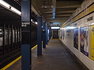
The Sutphin Boulevard station is a local station on the IND Queens Boulevard Line of the New York City Subway. Located at Sutphin Boulevard and Hillside Avenue in Jamaica, Queens, it is served by the F train at all times and the <F> train during rush hours in the reverse peak direction.

<span class="mw-page-title-main">Woodhaven Boulevard station (IND Queens Boulevard Line)</span> New York City Subway station in Queens

The Woodhaven Boulevard station is a local station on the IND Queens Boulevard Line of the New York City Subway, consisting of four tracks. Located in Elmhurst, Queens, it is served by the R train at all times except nights, and the E and F trains at night. The station serves the adjacent Queens Center Mall, as well as numerous bus lines.

Woodhaven Boulevard and Cross Bay Boulevard are two parts of a major boulevard in the New York City borough of Queens. Woodhaven Boulevard runs roughly north–south in the central portion of Queens. South of Liberty Avenue, it is known as Cross Bay Boulevard, which is the main north–south road in Howard Beach. Cross Bay Boulevard is locally known as simply "Cross Bay", and Woodhaven Boulevard, "Woodhaven". The completion of the boulevard in 1923, together with the construction of the associated bridges over Jamaica Bay, created the first direct roadway connection to the burgeoning Atlantic Ocean beachfront communities of the Rockaway Peninsula from Brooklyn and most of Queens.

<span class="mw-page-title-main">Q23 (New York City bus)</span> Bus route in Queens, New York

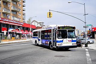
The Q23 bus route constitutes a public transit line in central Queens, New York City. The Q23 was formerly privately operated by the Triboro Coach Corporation, under a subsidized franchise with the New York City Department of Transportation (NYCDOT). The route is now operated by MTA Regional Bus Operations under the MTA Bus Company brand. The bus provides service between East Elmhurst in northwestern Queens to Glendale in central Queens, running mainly along 108th Street and providing access to the New York City Subway at the Forest Hills–71st Avenue station.

<span class="mw-page-title-main">Q37 (New York City bus)</span> Bus route in Queens, New York

The Q37 bus route constitutes a public transit line in Queens, New York City, running primarily along 111th Street between Kew Gardens and South Ozone Park. The Q37 was formerly privately operated by Green Bus Lines, under a subsidized franchise with the New York City Department of Transportation (NYCDOT). The route is now operated by MTA Regional Bus Operations under the MTA Bus Company brand.

<span class="mw-page-title-main">Select Bus Service</span> Bus service in New York City

Select Bus Service is a brand used by the Metropolitan Transportation Authority (MTA)'s Regional Bus Operations for limited-stop bus routes with some bus rapid transit features in New York City. The first SBS route was implemented in 2008 to improve speed and reliability on long, busy corridors.

The Queens Boulevard station was a local station on the demolished section of the BMT Jamaica Line in Queens, New York City. It had two tracks and two side platforms, with space for a third track in the center. This station was built as part of the Dual Contracts. It opened on July 3, 1918, and was closed in 1985 in anticipation of the Archer Avenue Subway, and due to political pressure in the area. The next stop to the north was Sutphin Boulevard, until it was closed in 1977 and Queens Boulevard became a terminal station. The next stop to the south was Metropolitan Avenue.

<span class="mw-page-title-main">Utica Avenue</span> Avenue in Brooklyn, New York

Utica Avenue is a major avenue in Brooklyn, New York City, New York, United States. It is one of several named for the city of Utica in Upstate New York. It runs north–south and occupies the position of East 50th Street in the Brooklyn street grid, with East 49th Street to its west and East 51st Street to its east for most of its path. The south end of Utica Avenue is at Flatbush Avenue; its north end is at Fulton Street, beyond which it is continued by Malcolm X Boulevard in Bedford–Stuyvesant. Malcolm X Boulevard continues to Broadway, where it terminates on Broadway between Lawton Street and Hart Street.

<span class="mw-page-title-main">Main Street (Queens)</span> Street in Queens, New York

Main Street is a major north–south street in the borough of Queens in New York City, extending from Queens Boulevard in Briarwood to Northern Boulevard in Flushing. Created in the 17th century as one of Flushing's main roads, Main Street has been lengthened at various points in its existence.

<span class="mw-page-title-main">Rockaway Boulevard</span> Boulevard in Queens, New York

Rockaway Boulevard is a major road in the New York City borough of Queens. Unlike the similarly named Rockaway Beach Boulevard and Rockaway Freeway, it serves mainland Queens and does not enter the Rockaways.

<span class="mw-page-title-main">Q60 (New York City bus)</span> Bus route in Queens, New York

The Q60 bus route constitutes a public transit line running primarily along Queens Boulevard in Queens, New York City, extending from Jamaica, Queens, to Midtown Manhattan via Queens Boulevard and the Queensboro Bridge. It is city-operated under the MTA Bus Company brand of MTA Regional Bus Operations.

<span class="mw-page-title-main">Bus lanes in New York City</span> Bus priority system

Since 1963, New York City has been using a system of bus lanes that are intended to give priority to buses, which contain more occupants than passenger and commercial vehicles. Most of these lanes are restricted to buses only at certain days and times, but some bus lanes are restricted 24/7. As of May 2021, there are 138.4 miles (222.7 km) of bus lanes within New York City.

<span class="mw-page-title-main">Woodhaven and Cross Bay Boulevards buses</span> Bus routes in Queens, New York

The Q11, Q21, Q52, and Q53 bus routes constitute a public transit corridor running along Woodhaven and Cross Bay Boulevards in Queens, New York City. The corridor extends primarily along the length of the two boulevards through "mainland" Queens, a distance of 6 miles (9.7 km) between Elmhurst and the Jamaica Bay shore in Howard Beach. The Q52 and Q53 buses, which provide Select Bus Service along the corridor, continue south across Jamaica Bay to the Rockaway peninsula, one of the few public transit options between the peninsula and the rest of the city.

<span class="mw-page-title-main">Q65 (New York City bus)</span> Bus route in Queens, New York

The Q65 bus route constitutes a public transit line in Queens, New York City. The south-to-north route runs primarily on 164th Street, operating between two major bus-subway hubs: Sutphin Boulevard–Archer Avenue station in Jamaica and Flushing–Main Street station in Flushing. It then extends north along College Point Boulevard to College Point at the north end of the borough. The route is city-operated under the MTA Bus Company brand of MTA Regional Bus Operations.

<span class="mw-page-title-main">Q25 and Q34 buses</span> Bus routes in Queens, New York City

The Q25 and Q34 bus routes constitute a public transit line in Queens, New York City. The south-to-north route runs primarily on Parsons Boulevard and Kissena Boulevard, serving two major bus-subway hubs: Sutphin Boulevard–Archer Avenue–Jamaica and Flushing–Main Street. The Q25 terminates in College Point, and the Q34 in Whitestone, both in northern Queens.

<span class="mw-page-title-main">Hillside Avenue buses</span> Bus routes in Queens, New York

The Q1, Q36, and Q43 bus routes constitute a public transit line in Queens, New York City. The routes run primarily along Hillside Avenue from the Jamaica, Queens commercial and transportation hub towards several eastern Queens neighborhoods on the city border with Nassau County. Originally operated by the North Shore Bus Company until 1947, all three routes are now operated by MTA Regional Bus Operations under the New York City Transit brand.

<span class="mw-page-title-main">Lefferts Boulevard</span> Street in Queens, New York

Lefferts Boulevard is a major north–south thoroughfare in Queens, New York City, running through the communities of Kew Gardens, Richmond Hill, and South Ozone Park. Its northern end is at Kew Gardens Road, in Kew Gardens, and its southern end is located within John F. Kennedy International Airport. Lefferts Boulevard intersects with other major roads such as Metropolitan Avenue, Jamaica Avenue, and Atlantic Avenue. It is 119th Street for its entire run.

References

  1. 1 2 3 Google (May 23, 2019). "Jamaica Avenue" (Map). Google Maps . Google. Retrieved May 23, 2019.
  2. "History of Jamaica Avenue: Richmond Hill Historical Society". www.richmondhillhistory.org. Retrieved 2016-07-04.
  3. MTA Regional Bus Operations. "Q56 bus schedule".
  4. MTA Regional Bus Operations. "Q110 bus schedule".
  5. MTA Regional Bus Operations. "Q36 bus schedule".
  6. Gartland, Michael (June 8, 2020). "De Blasio announces 20 miles of new express MTA busways as NYC begins to reopen". nydailynews.com. Retrieved June 8, 2020.
  7. "Better Buses Restart: Mayor de Blasio Announces Major Projects to Speed Buses During City's Phased Reopening". The official website of the City of New York. June 8, 2020. Retrieved June 8, 2020.
  8. Guse, Clayton (December 7, 2020). "De Blasio's plan to add new 'busways' in NYC for essential workers falls short". New York Daily News. Retrieved February 21, 2021.
  9. Maisel, Todd (2020-10-22). "Finish the job! Transit advocates rally in Queens for bus lane completion". amNewYork. Retrieved 2021-06-05.
  10. Cuba, Julianne (2020-09-03). "Queens Pols Want a Jamaica Busway - Just Not Where de Blasio Put It". Streetsblog New York City. Retrieved 2021-06-05.