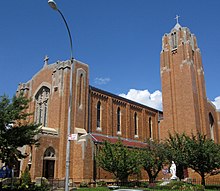
Bay Ridge is a neighborhood in the southwest corner of the New York City borough of Brooklyn. It is bounded by Sunset Park to the north, Dyker Heights to the east, the Narrows and the Belt Parkway to the west, and Fort Hamilton Army Base and the Verrazzano-Narrows Bridge to the south. The section of Bay Ridge south of 86th Street is sometimes considered part of a sub-neighborhood called Fort Hamilton.

The Independent Subway System was a rapid transit rail system in New York City that is now part of the New York City Subway. It was first constructed as the Eighth Avenue Line in Manhattan in 1932. It was originally also known as the Independent City-Owned Subway System (ICOSS) or the Independent City-Owned Rapid Transit Railroad (ICORTR).
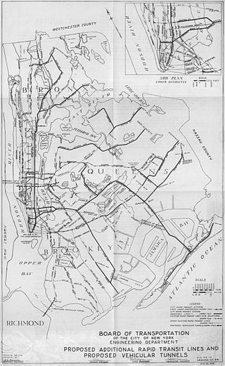
Since the opening of the original New York City Subway line in 1904, and throughout the subway's history, various official and planning agencies have proposed numerous extensions to the subway system. The first major expansion of the subway system was the Dual Contracts, a set of agreements between the City of New York and the IRT and the BRT. The system was expanded into the outer reaches of the Bronx, Brooklyn, and Queens, and it provided for the construction of important lines in Manhattan. This one expansion of the system provided for a majority of today's system.

The Belt Parkway is the name given to a series of connected limited-access highways that form a belt-like circle around the New York City boroughs of Brooklyn and Queens. The Belt Parkway comprises three of the four parkways in what is known as the Belt System: the Shore Parkway, the Southern Parkway, and the Laurelton Parkway. The three parkways in the Belt Parkway are a combined 25.29 miles (40.70 km) in length. The Cross Island Parkway makes up the fourth parkway in the system, but is signed separately.
The IND Culver Line is a rapid transit line of the B Division of the New York City Subway, extending from Downtown Brooklyn south to Coney Island, Brooklyn, New York City, United States. The local tracks of the Culver Line are served by the F service, as well as the G between Bergen Street and Church Avenue. The express tracks north of Church Avenue are used by the <F> train during rush hours in the peak direction. The peak-direction express track between Ditmas Avenue and Avenue X has not seen regular service since 1987.

The Culver Shuttle was a New York City Subway shuttle, running along a remnant of the BMT Culver Line, most of which is now the IND Culver Line. The shuttle was originally part of the Brooklyn-Manhattan Transit Corporation (BMT)'s 5 service, providing through service on the Culver Line between Coney Island and Manhattan. The F train is the current successor to Culver Line service. The line had 1,000 riders a day during its final month of service in 1975.
The BMT Fourth Avenue Line is a rapid transit line of the New York City Subway, mainly running under Fourth Avenue in Brooklyn. The line is served by the D, N, and R at all times; the R typically runs local, while the D and N run express during the day and local at night. During rush hours, select W and northbound Q trains also serve the line. Northbound D and N trains run local along the line after 6:45 p.m. during weekdays as well. The line was originally built by the Brooklyn Rapid Transit Company and is now internally operated as part of the New York City Subway's B Division.

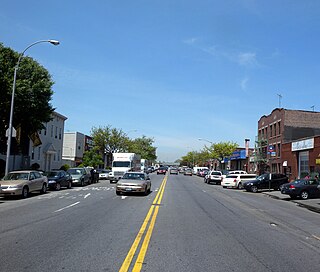
Bay Parkway is a 2.7-mile (7.82 km) boulevard/parkway in the west portion of the New York City borough of Brooklyn.
Kings Highway is a broad avenue that curves about the southern part of the Borough of Brooklyn in New York City. Its west end is at Bay Parkway and 78th Street. East of Ocean Avenue, the street is largely residential. It tracks eastward, then northeast, then north through Brooklyn and reaches East 98th Street in central Brooklyn. At that point, it flows into Howard Avenue to provide seamless access to Eastern Parkway, another major road in Brooklyn with side medians and service roads.

The Bay Ridge–95th Street station is the southern terminal station on the BMT Fourth Avenue Line of the New York City Subway. Despite the name, the station is located in the neighborhood of Fort Hamilton at the intersection of 95th Street and Fourth Avenue in southwestern Brooklyn. It is served by the R train at all times. Geographically, this station is the westernmost New York City Subway station.

The Fort Hamilton Parkway station is a local station on the IND Culver Line of the New York City Subway. It is served by the F and G trains at all times.

The Fort Hamilton Parkway station is a local station on the BMT Sea Beach Line of the New York City Subway, located in Borough Park, Brooklyn at the intersection of Fort Hamilton Parkway and 62nd Street. It is served by the N train at all times. During rush hours, several W and northbound Q trains also serve the station.

The Ninth Avenue station is a bi-level express station on the BMT West End Line of the New York City Subway, located at the intersection of Ninth Avenue and 39th Street in Brooklyn. Each level has three tracks and two island platforms. The upper level serves the BMT West End Line while the lower level formerly served the BMT Culver Line. Only the upper level is still in service and is served by the D train at all times.
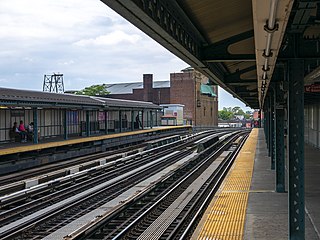
The Fort Hamilton Parkway station is a local station on the BMT West End Line of the New York City Subway, located in Brooklyn at the intersection of Fort Hamilton Parkway and New Utrecht Avenue, in the neighborhood of Borough Park. It is served by the D train at all times. The station opened in 1916, and had its platforms extended in the 1960s.
Stillwell Avenue is a major two-way north–south thoroughfare in southern Brooklyn and the central section of Coney Island. It is 2.4 miles (3.9 km) long and begins at a dead end at Riegelmann Boardwalk on Coney Island. The road goes north, leaving Coney Island, ending at Bay Parkway, where the road continues as the Bay Ridge Parkway. On December 11, 2008, it acquired the subsidiary name Polar Bear Club Walk, named for the Coney Island Polar Bear Club. The Stillwell Avenue/Surf Avenue intersection on Coney Island is the location of the Coney Island–Stillwell Avenue subway station, a major subway station in New York City.
The Fort Hamilton Parkway station was a station on the demolished section of the BMT Culver Line. It was located at the intersection of 37th Street and Fort Hamilton Parkway in Brooklyn, New York City.
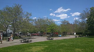
John J. Carty Park, also known as Rubber Park, is located in Bay Ridge, Brooklyn. This park honors John J. Carty (1909–1970), a native of Bay Ridge, Brooklyn who lived his life only five blocks away and dedicated himself to New York City government for 32 years.

The Staten Island Tunnel is an abandoned, incomplete railway/subway tunnel in New York City. It was intended to connect railways on Staten Island to the BMT Fourth Avenue Line of the New York City Subway, in Brooklyn, via a new crossing under the Narrows. Planned to extend 10,400 feet (3,200 m), the tunnel would have been among the world's longest at the time of its planning, in the late 19th and early 20th centuries.