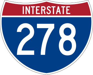
Interstate 278 (I-278) is an auxiliary Interstate Highway in New Jersey and New York in the United States. The road runs 35.62 miles (57.32 km) from US Route 1/9 (US 1/9) in Linden, New Jersey, northeast to the Bruckner Interchange in the New York City borough of the Bronx. The majority of I-278 is in New York City, where it serves as a partial beltway and passes through all five of the city's boroughs. I-278 follows several freeways, including the Union Freeway in Union County, New Jersey; the Staten Island Expressway (SIE) across Staten Island; the Gowanus Expressway in southern Brooklyn; the Brooklyn–Queens Expressway (BQE) across northern Brooklyn and Queens; a small part of the Grand Central Parkway in Queens; and a part of the Bruckner Expressway in the Bronx. I-278 also crosses multiple bridges, including the Goethals, Verrazzano-Narrows, Kosciuszko, and Robert F. Kennedy bridges.

The Belt Parkway is the name given to a series of connected limited-access highways that form a belt-like circle around the New York City boroughs of Brooklyn and Queens. The Belt Parkway comprises three of the four parkways in what is known as the Belt System: the Shore Parkway, the Southern Parkway, and the Laurelton Parkway. The three parkways in the Belt Parkway are a combined 25.29 miles (40.70 km) in length. The Cross Island Parkway makes up the fourth parkway in the system, but is signed separately.
Kensington is a neighborhood in the central portion of the New York City borough of Brooklyn, located south of Prospect Park and Green-Wood Cemetery. It is bordered by Coney Island Avenue to the east; Fort Hamilton Parkway and Caton Avenue to the north; McDonald Avenue and 36th Street to the west; and Ditmas Avenue or Foster Avenue to the south. Kensington and Parkville are bordered by the Prospect Park South and Ditmas Park subsections of Flatbush to the east; Windsor Terrace to the north; Borough Park to the west; and Midwood to the south.

Windsor Terrace is a small residential neighborhood in the central part of the New York City borough of Brooklyn. It is bounded by Prospect Park on the east and northeast, Park Slope at Prospect Park West, Green-Wood Cemetery, and Borough Park at McDonald Avenue on the northwest, west, and southwest, and Kensington at Caton Avenue on the south. As of the 2010 United States Census, Windsor Terrace had 20,988 people living within its 0.503-square-mile (1.30 km2) area.

Flatbush Avenue is a major avenue in the New York City Borough of Brooklyn. It runs from the Manhattan Bridge south-southeastward to Jamaica Bay, where it joins the Marine Parkway–Gil Hodges Memorial Bridge, which connects Brooklyn to the Rockaway Peninsula in Queens. The north end was extended from Fulton Street to the Manhattan Bridge as "Flatbush Avenue Extension".

Atlantic Avenue is a major thoroughfare in the New York City boroughs of Brooklyn and Queens. It stretches from the Brooklyn waterfront on the East River all the way to Jamaica, Queens. Atlantic Avenue runs parallel to Fulton Street for much of its course through Brooklyn, where it serves as a border between the neighborhoods of Prospect Heights and Fort Greene and between Bedford-Stuyvesant and Crown Heights.

New York State Route 27 (NY 27) is a 120.58-mile (194.05 km) long state highway that runs east–west from Interstate 278 (I-278) in the New York City borough of Brooklyn to Montauk Point State Park on Long Island, New York. Its two most prominent components are Sunrise Highway and Montauk Highway, the latter of which includes the Montauk Point State Parkway. NY 27 acts as the primary east–west highway on southern Long Island east of the interchange with the Heckscher State Parkway in Islip Terrace. The entire route in Suffolk, Nassau, and Queens counties were designated by the New York State Senate as the POW/MIA Memorial Highway. The highway gives access to every town on the South Shore. NY 27 is the easternmost state route in the state of New York.

Community boards of Brooklyn are New York City community boards in the borough of Brooklyn, which are the appointed advisory groups of the community districts that advise on land use and zoning, participate in the city budget process, and address service delivery in their district.
Kings Highway is a broad avenue that curves about the southern part of the Borough of Brooklyn in New York City. Its west end is at Bay Parkway and 78th Street. East of Ocean Avenue, the street is largely residential. It tracks eastward, then northeast, then north through Brooklyn and reaches East 98th Street in central Brooklyn. At that point, it flows into Howard Avenue to provide seamless access to Eastern Parkway, another major road in Brooklyn with side medians and service roads.

Ocean Parkway is a 4.86-mile (7.82 km) boulevard in the west-central portion of the New York City borough of Brooklyn. It is inventoried by the New York State Department of Transportation (NYSDOT) as New York State Route 908H (NY 908H), an unsigned reference route.

Eastern Parkway is a major road that runs through a portion of the New York City borough of Brooklyn. Designed by Frederick Law Olmsted and Calvert Vaux, it was the world's first parkway, having been built between 1870 and 1874. At the time of its construction, Eastern Parkway went to the eastern edge of Brooklyn, hence its name.
The B33 was a public transit line in Brooklyn, New York City, running mostly along Hamilton Avenue between Bay Ridge and Hamilton Ferry at the north end of the avenue in Red Hook. Originally a streetcar line known as the Hamilton Avenue Line, it was replaced by a bus route, but is no longer operated.

The B82 bus route constitutes a public transit line in central Brooklyn, New York City. It connects Starrett City in southeast Brooklyn with Coney Island on Brooklyn's southwestern coast. The B82 operates primarily via Kings Highway and Flatlands Avenue in southern Brooklyn. The route is operated by MTA Regional Bus Operations, under the New York City Bus and Select Bus Service brands.
Ocean Avenue is a major street in Brooklyn, New York that runs generally north-south and occupies the position of East 20th Street in the Brooklyn street grid, with East 19th Street to its west and East 21st Street to its east for most of its path. It runs east of and parallel to Ocean Parkway and Coney Island Avenue for most of its route. Except for a short stretch on the Manhattan Beach peninsula, Ocean Avenue starts in the south at Emmons Avenue in Sheepshead Bay just south of the Belt Parkway and continues north, ending at Flatbush Avenue at Willink Plaza after running for several blocks as the eastern edge of Prospect Park. A footbridge across Sheepshead Bay connects the two "Ocean Avenue" sections.

Fourth Avenue is a major thoroughfare in the New York City borough of Brooklyn. It stretches for 6 miles (9.7 km) south from Times Plaza, which is the triangle intersection created by Atlantic and Flatbush Avenues in Downtown Brooklyn, to Shore Road and the Belt Parkway in Bay Ridge.

The Flatbush Malls are a series of tree-lined landscaped medians along several roads in the Victorian Flatbush neighborhood of Brooklyn, New York City. An architecture critic has written that the malls "give the streets an uncommon spaciousness, if not grandeur". The first series was built in the northern part of the neighborhood along Albemarle Road, and extending one block north on Buckingham Road, in the Prospect Park South development of 1899, east of Coney Island Avenue and west of the BMT Brighton Line. This was modeled by the Scottish landscape architect John Aiken on Commonwealth Avenue Mall in Boston, with a design that originally included shrubbery but not trees, and in turn likely inspired the other neighborhood series. The second series, also known as the Midwood Malls, was built in the southern part of the neighborhood along both Glenwood Road, east of Coney Island Avenue and west of Delamere Place, as well as the intersecting East 17th Street, north of the Long Island Railroad cut of the Bay Ridge Branch and south of Foster Avenue, in the Fiske Terrace-Midwood Park developments of 1905.