Flushing Avenue

Last updated
Flushing Avenue
Flushing Av head end in Maspeth jeh.jpg
Flushing Avenue in Maspeth
Namesake Vlissingen
Owner City of New York
Maintained by NYCDOT
Length4.8 mi (7.7 km) [1]
Location Brooklyn, Queens
Postal code11201, 11205, 11211, 11206, 11237, 11385, 11378
Nearest metro station Flushing Avenue NYCS-bull-trans-G-Std.svg
Flushing Avenue NYCS-bull-trans-J-Std.svg NYCS-bull-trans-M-Std.svg
Jefferson Street NYCS-bull-trans-L-Std.svg
West endNassau Street / Navy Street in Fort Greene
Major
junctions
I-278.svg I-278 in Clinton Hill
East end Grand Avenue (Queens) in Maspeth
Western Flushing Avenue Flushing Av west jeh.JPG
Western Flushing Avenue
All Saints Catholic Church at Flushing and Throop Avenues Throop Flushing church jeh.JPG
All Saints Catholic Church at Flushing and Throop Avenues

Flushing Avenue is a street running through northern Brooklyn and western Queens, beginning at Nassau Street in Fort Greene, Brooklyn, and ending at Grand Avenue in Maspeth. It divides the neighborhood of Williamsburg from Clinton Hill and East Williamsburg from Bushwick. After crossing the Queens border, the avenue serves as the dividing line between Ridgewood, Queens and West Maspeth. Flushing Avenue then terminates in Maspeth. Despite its name, however, the avenue does not extend to Flushing.

Contents

Route description

The avenue is primarily an industrial thoroughfare. On its extreme western end, it serves the Brooklyn Navy Yard, a former naval shipyard turned industrial park. [2] Part of the Brooklyn Waterfront Greenway bike path runs alongside Flushing Avenue in this area. [3] In this district, the south side of Flushing Avenue contains many abandoned business that were supported by sailors and ship workers before the government closed the yard.

Continuing eastward, Flushing Avenue crosses the Brooklyn-Queens Expressway. This section of Flushing Avenue, between the expressway and Broadway, has seen considerable redevelopment over recent years by Williamsburg's Hasidic population, as young urban professionals have moved into the northern end of Williamsburg. The north side of Flushing Avenue in this section is a primarily residential area, whereas the south side is primarily industrial, the most notable exception being the Marcy Houses housing project. The Flushing Avenue subway station is at Flushing and Marcy Avenues.

Flushing Avenue forms the south side of the so-called "Broadway Triangle", bounded on the northeast by Broadway and on the west by Union Avenue, whose factories were largely abandoned shortly after the turn of the 21st century. The Triangle was rezoned as "residential" in December 2009. [4]

The commercial heart of Flushing Avenue is the intersection with Broadway and Graham Avenue, in the extreme southern end of Williamsburg. This business improvement district is serviced by the J and M trains' Flushing Avenue stop. In this area are cheap retail shopping, food shops and fast-food chains. This primarily Puerto Rican and Hasidic area is becoming increasingly populated with students and young professionals. [ citation needed ]

Near the intersection with Bushwick Avenue, residential Bushwick borders Flushing Avenue to the south, and the massive Bushwick Houses to the north. At Morgan and at Wyckoff Avenue, a community of artists and young professionals have moved into the low-rise lofts that were once abandoned. An effect of this gentrification was the opening of two bar-restaurants, Life Cafe and the Wreck Room, on an adjacent section of Flushing Avenue.[ citation needed ]

Continuing past Wyckoff Avenue, the avenue crosses into Queens, passes the historic Vander Ende-Onderdonk House Site (formerly in Brooklyn, now Queens), and becomes actively industrial on both sides. Upon entering Maspeth, it is a residential street.

History

In 1951, eighteen traffic signals at the western end of Flushing Avenue, as well as along Park Avenue in Fort Greene, were re-timed to increase the flow of traffic heading west to the Manhattan Bridge. [5]

Flushing Avenue has seen considerable decline since its heyday in the early and mid-20th century. Some sections began to gentrify, to varying degrees, at the turn of the 21st century. In 2004, the city began a project to upgrade the water and sewer infrastructure on the western part of the road, and to repave it; the project was completed in 2008.

Transportation

The B57 bus runs the entire length of the avenue. [6] There are two New York City Subway stations along Flushing Avenue. The G train stops at Flushing Avenue and Union Avenue. The J and M trains stop at Flushing Avenue and Broadway. The L train also stops nearby at the Jefferson Street station. [7]

Related Research Articles

<span class="mw-page-title-main">J/Z (New York City Subway service)</span> New York City Subway services

The J Nassau Street Local and Z Nassau Street Express are two rapid transit services in the B Division of the New York City Subway. Their route emblems, or "bullets", are colored brown since they use the BMT Nassau Street Line in Lower Manhattan.

<span class="mw-page-title-main">East Williamsburg, Brooklyn</span> Neighborhood of Brooklyn in New York City

East Williamsburg is a name for the area in the northwestern portion of Brooklyn, New York City, United States. East Williamsburg consists roughly of what was the 3rd District of the Village of Williamsburgh and what is now called the East Williamsburg In-Place Industrial Park (EWIPIP), bounded by the neighborhoods of Northside and Southside Williamsburg to the west, Greenpoint to the north, Bushwick to the south and southeast, and both Maspeth and Ridgewood in Queens to the east. Much of this area is still referred to as either Bushwick, Williamsburg, or Greenpoint with the term East Williamsburg falling out of use since the 1990s.

<span class="mw-page-title-main">Williamsburg, Brooklyn</span> Neighborhood of Brooklyn in New York City

Williamsburg is a neighborhood in the New York City borough of Brooklyn, bordered by Greenpoint to the north; Bedford–Stuyvesant to the south; Bushwick and East Williamsburg to the east; and the East River to the west. It was an independent city until 1855, when it was annexed by Brooklyn; at that time, the spelling was changed from Williamsburgh to Williamsburg.

<span class="mw-page-title-main">L (New York City Subway service)</span> New York City Subway service

The L 14th Street–Canarsie Local is a rapid transit service in the B Division of the New York City Subway. Its route emblem, or "bullet", is colored medium gray since it serves the BMT Canarsie Line.

<span class="mw-page-title-main">Bushwick, Brooklyn</span> Neighborhood of New York City

Bushwick is a neighborhood in the northern part of the New York City borough of Brooklyn. It is bounded by the neighborhood of Ridgewood, Queens, to the northeast; Williamsburg to the northwest; East New York and the cemeteries of Highland Park to the southeast; Brownsville to the south; and Bedford–Stuyvesant to the southwest.

<span class="mw-page-title-main">Maspeth, Queens</span> Neighborhood of Queens in New York City

Maspeth is a residential and commercial community in the borough of Queens in New York City. It was founded in the early 17th century by Dutch and English settlers. Neighborhoods sharing borders with Maspeth are Woodside to the north; Sunnyside to the northwest; Greenpoint, Brooklyn to the west; East Williamsburg, Brooklyn to the southwest; Fresh Pond and Ridgewood to the south; and Middle Village and Elmhurst to the east.

<span class="mw-page-title-main">Glendale, Queens</span> Neighborhoods of Queens in New York City

Glendale is a neighborhood in the west-central portion of the New York City borough of Queens. It is bounded by Forest Hills to the east, Ridgewood to the west, Woodhaven to the south, and Middle Village to the north.

The BMT Canarsie Line is a rapid transit line of the B Division of the New York City Subway system, named after its terminus in the Canarsie neighborhood of Brooklyn. It is served by the L train at all times, which is shown in medium gray on the New York City Subway map and on station signs.

<span class="mw-page-title-main">Ridgewood, Queens</span> Neighborhood of Queens in New York City

Ridgewood is a neighborhood in the New York City borough of Queens. It borders the Queens neighborhoods of Maspeth to the north, Middle Village to the east, and Glendale to the southeast, as well as the Brooklyn neighborhoods of Bushwick to the southwest and East Williamsburg to the west. Historically, the neighborhood straddled the Queens-Brooklyn boundary.

<span class="mw-page-title-main">Myrtle Avenue</span> Avenue in Brooklyn and Queens, New York

Myrtle Avenue is a 8.1-mile-long (13.0 km) street that runs from Duffield Street in Downtown Brooklyn to Jamaica Avenue in Richmond Hill, Queens, in New York City, United States. Myrtle is a main thoroughfare through the neighborhoods of Fort Greene, Clinton Hill, Bedford-Stuyvesant, Bushwick, Ridgewood, and Glendale.

<span class="mw-page-title-main">Halsey Street station (BMT Canarsie Line)</span> New York City Subway station in Brooklyn and Queens

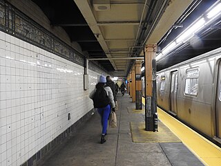
The Halsey Street station is a station on the BMT Canarsie Line of the New York City Subway. Located on the border of Ridgewood, Queens, and Bushwick, Brooklyn, at the intersection of Halsey Street and Wyckoff Avenue, it is served by the L train at all times.

<span class="mw-page-title-main">Myrtle–Wyckoff Avenues station</span> New York City Subway station

The Myrtle–Wyckoff Avenues station is a New York City Subway station complex formed by the intersecting stations of the BMT Canarsie Line and the BMT Myrtle Avenue Line, served by the L and M trains at all times. It is located at Myrtle Avenue and Wyckoff Avenue in the Bushwick neighborhood of Brooklyn and the Ridgewood neighborhood of Queens. The complex is connected by a set of stairs and several elevators and escalators between the elevated and underground levels. The station was renovated completely from 2004 to 2008.

<span class="mw-page-title-main">DeKalb Avenue station (BMT Canarsie Line)</span> New York City Subway station in Brooklyn

The DeKalb Avenue station is a station on the BMT Canarsie Line of the New York City Subway. Located at the intersection of Wyckoff and DeKalb Avenues in Bushwick, Brooklyn, it is served by the L train at all times.

<span class="mw-page-title-main">Marcy Avenue station</span> New York City Subway station in Brooklyn

The Marcy Avenue station is a station on the BMT Jamaica Line of the New York City Subway. Located at the intersection of Marcy Avenue and Broadway in Brooklyn, it is served by the J train at all times, the M train at all times except late nights, and the Z train during rush hours in the peak direction.

<span class="mw-page-title-main">Q59 (New York City bus)</span> Bus route in Queens and Brooklyn, New York

The Grand Street Line is a public transit line in Brooklyn and Queens, New York City, running mostly along the continuous Grand Street and Grand Avenue between Williamsburg, Brooklyn and Maspeth, Queens. It then continues down Queens Boulevard to the 63rd Drive–Rego Park station. Originally a streetcar line, it is now the Q59 bus route, operated by the New York City Transit Authority between Williamsburg and Rego Park, Queens.

<span class="mw-page-title-main">Grand Street and Grand Avenue</span> Avenue in Brooklyn and Queens, New York

Grand Street and Grand Avenue are the respective names of a street which runs through the boroughs of Brooklyn and Queens, New York City, United States. Originating in Williamsburg, Brooklyn, Grand Street runs roughly northeast until crossing Newtown Creek into Queens, whereupon Grand Street becomes Grand Avenue, continuing through Maspeth where it is a main shopping street, until reaching its northern end at Queens Boulevard in Elmhurst.

<span class="mw-page-title-main">Bushwick Branch</span> Long Island Rail Road freight branch in New York City

The Bushwick Branch, also called the Bushwick Lead Track, is a freight railroad branch in New York City. It runs from the East Williamsburg neighborhood of Brooklyn to Fresh Pond Junction in the Glendale neighborhood of Queens, where it connects with the Montauk Branch of the Long Island Rail Road. It is owned by the LIRR but operated under lease by the New York and Atlantic Railway, which took over LIRR freight operations in May 1997.

<span class="mw-page-title-main">Broadway (Brooklyn)</span> Avenue in Brooklyn, New York

Broadway is an avenue in the New York City borough of Brooklyn that extends from the East River in the neighborhood of Williamsburg in a southeasterly direction to East New York for a length of 4.32 miles (6.95 km). It was named for the Broadway in Manhattan. The East New York terminus is a complicated intersection with East New York Avenue, Fulton Street, Jamaica Avenue, and Alabama Avenue. The BMT Jamaica Line of the New York City Subway runs on elevated tracks over Broadway from the Williamsburg Bridge to East New York on its way to Queens. Broadway forms the boundary between the neighborhoods of Bushwick, which lies above Broadway to the northeast, and Bedford–Stuyvesant, which is to the southwest.

<span class="mw-page-title-main">Q58 (New York City bus)</span> Bus route in Queens, New York

The Q58 and Q58 Limited are bus routes that constitute a public transit line operating primarily in Queens, New York City, with its southern terminal on the border with Brooklyn. The Q58 is operated by the MTA New York City Transit Authority. Its precursor was a streetcar line that began operation in November 1899. and was known variously as the Flushing–Ridgewood Line, the Corona Avenue Line, and the Fresh Pond Road Line. The route became a bus line in 1949.

References

  1. Google (January 9, 2017). "Flushing Avenue" (Map). Google Maps . Google. Retrieved January 9, 2017.
  2. Hughes, C.J. (November 1, 2015). "Reinventing the Brooklyn Navy Yard". The New York Times. Retrieved September 4, 2018.
  3. Kuntzman, Gersh (October 22, 2018). "Eyes on the Street: Flushing Avenue Bike Lane Takes Shape". Streetsblog New York City. Retrieved April 15, 2019.
  4. Campbell, Andy (December 22, 2009). "Council OK's Broadway Triangle rezoning". Brooklyn Paper. Archived from the original on September 17, 2011.
  5. "New Traffic Signals; Progressive Operation Aids Manhattan Bridge Flow". The New York Times. August 2, 1951. Retrieved January 15, 2024; "Progressive Lights to Speed Traffic to Manhattan Bridge". The Brooklyn Daily Eagle. 1951-08-02. p. 13. Retrieved 2024-01-15.
  6. "Brooklyn Bus Map" (PDF). Metropolitan Transportation Authority. October 2020. Retrieved December 1, 2020.
  7. "Subway Map" (PDF). Metropolitan Transportation Authority. September 2021. Retrieved September 17, 2021.

Further reading

Template:Attached KML/Flushing Avenue
KML is from Wikidata