The Erie Canal is a historic canal in upstate New York that runs east–west between the Hudson River and Lake Erie. Completed in 1825, the canal was the first navigable waterway connecting the Atlantic Ocean to the Great Lakes, vastly reducing the costs of transporting people and goods across the Appalachians. In effect, the canal accelerated the settlement of the Great Lakes region, the westward expansion of the United States, and the economic ascendancy of New York State. It has been called "The Nation's First Superhighway."

The Portage Lakes are a group of glacial kettle lakes and reservoirs in Northeast Ohio. The name comes from an old Indian portage path that connected the Cuyahoga River flowing north to Lake Erie and the Tuscarawas River, a tributary of the Muskingum River, which flows south to the Ohio River. This proved advantageous for the Indians and early settlers as navigation from Lake Erie to the Ohio was possible with only an eight-mile portage. Portage Lakes State Park lies at one of the highest points of the state and on a major watershed divide in Ohio. Some water from the lakes reaches Lake Erie and some flows to the Ohio River.

Dresden is a village in Muskingum County, Ohio, United States, along the Muskingum River at the mouth of Wakatomika Creek. The population was 1,650 at the 2020 census. It is part of the Zanesville micropolitan area. It was incorporated on March 9, 1835.

Lowell is a village in Washington County, Ohio, United States, along the Muskingum River. The population was 549 at the 2020 census. The village is located about 7.6 miles (12.2 km) north of Marietta, Ohio.
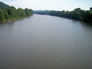
The Muskingum River is a tributary of the Ohio River, approximately 111 miles (179 km) long, in southeastern Ohio in the United States. An important commercial route in the 19th century, it flows generally southward through the eastern hill country of Ohio. Via the Ohio, it is part of the Mississippi River watershed. The river is navigable for much of its length through a series of locks and dams.

The Wabash and Erie Canal was a shipping canal that linked the Great Lakes to the Ohio River via an artificial waterway. The canal provided traders with access from the Great Lakes all the way to the Gulf of Mexico. Over 460 miles long, it was the longest canal ever built in North America.

Muskingum University is a private university in New Concord, Ohio. Chartered in 1837 as Muskingum College, the institution is affiliated with the Presbyterian Church (USA). New Concord is located in far eastern Muskingum County, which derives its name from the Muskingum River. Muskingum offers more than 40 academic majors. Graduate programs are offered in education and management information systems, strategy and technology. Muskingum's campus consists of 21 buildings, a football stadium, and a small lake which all sit atop 225 acres (0.91 km2) of rolling hills overlooking New Concord. Alumni are referred to as the "Long Magenta Line" and students are known simply as "Muskies" while its athletic teams are called the "Fighting Muskies".
The Miami and Erie Canal was a 274-mile (441 km) canal that ran from Cincinnati to Toledo, Ohio, creating a water route between the Ohio River and Lake Erie. Construction on the canal began in 1825 and was completed in 1845 at a cost to the state government of $8,062,680.07. At its peak, it included 19 aqueducts, three guard locks, 103 canal locks, multiple feeder canals, and a few man-made water reservoirs. The canal climbed 395 feet (120 m) above Lake Erie and 513 feet (156 m) above the Ohio River to reach a topographical peak called the Loramie Summit, which extended 19 miles (31 km) between New Bremen, Ohio to lock 1-S in Lockington, north of Piqua, Ohio. Boats up to 80 feet long were towed along the canal by mules, horses, or oxen walking on a prepared towpath along the bank, at a rate of four to five miles per hour.

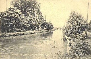
The Ohio and Erie Canal was a canal constructed during the 1820s and early 1830s in Ohio. It connected Akron with the Cuyahoga River near its outlet on Lake Erie in Cleveland, and a few years later, with the Ohio River near Portsmouth. It also had connections to other canal systems in Pennsylvania.
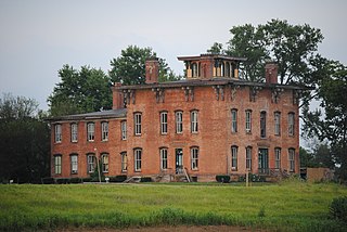
Prospect Place, also known as The Trinway Mansion and Prospect Place Estate is a 29-room mansion built by abolitionist George Willison Adams in Trinway, Ohio, just north of Dresden in 1856. Today, it is the home of the non-profit G. W. Adams Educational Center, Inc. The mansion is listed on the National Register of Historic Places and the Ohio Underground Railroad Association's list of Underground Railroad sites.

This is a list of properties and districts in Ohio that are listed on the National Register of Historic Places. There are over 4.000 in total. Of these, 73 are National Historic Landmarks. There are listings in each of Ohio's 88 counties.

Wakatomika is an unincorporated community in central Washington Township, Coshocton County, Ohio, United States. Wakatomika is located on the Little Wakatomika Creek, and lies along State Route 60.

The Sandy and Beaver Canal was a canal and lock transportation system which ran seventy-three miles from the Ohio and Erie Canal at Bolivar, Ohio, to the Ohio River at Glasgow, Pennsylvania.

Newton Township is one of the twenty-five townships of Muskingum County, Ohio, United States. The 2020 census found 5,247 people in the township.
Cass Township is one of the twenty-five townships of Muskingum County, Ohio, United States. The 2020 census found 1,811 people in the township.

Jefferson Township is one of the twenty-five townships of Muskingum County, Ohio, United States. The 2020 census found 1,850 people in the township

Madison Township is one of the twenty-five townships of Muskingum County, Ohio, United States. The 2020 census found 496 people in the township.

Duncan Falls is a census-designated place in southeastern Wayne Township, Muskingum County, Ohio, United States, located on State Route 60 south of the city of Zanesville. It has a post office with the ZIP Code 43734. Duncan Falls has a public library, a branch of the Muskingum County Library System. The population was 898 at the 2020 census.

Gaston's Mill-Lock No. 36, Sandy and Beaver Canal District, is a historic district listed in the National Register of Historic Places. The district is located within Beaver Creek State Park, approximately 1 mile south of Clarkson, Ohio. Gaston's Mill was constructed in 1837 and was powered by Little Beaver Creek. Lock 36 was one of 90 locks on the Sandy and Beaver Canal. Construction of this canal began in 1834 but was not completed until 1848.

Antrim is an unincorporated community in Guernsey County, in the U.S. state of Ohio.