North Zanesville, Ohio

Last updated

North Zanesville, Ohio
CDP
OHMap-doton-North Zanesville.png
Location of North Zanesville, Ohio
Coordinates: 39°59′4″N82°0′4″W / 39.98444°N 82.00111°W / 39.98444; -82.00111
Country United States
State Ohio
County Muskingum
Area
[1]
  Total3.55 sq mi (9.20 km2)
  Land3.55 sq mi (9.19 km2)
  Water0.00 sq mi (0.01 km2)
Elevation
[2]
902 ft (275 m)
Population
 (2020)
  Total3,116
  Density877.75/sq mi (338.91/km2)
Time zone UTC-5 (Eastern (EST))
  Summer (DST) UTC-4 (EDT)
FIPS code 39-57218 [3]
GNIS feature ID1049023 [2]

North Zanesville is a census-designated place (CDP) in Muskingum County, Ohio, United States, just north of the city of Zanesville, along the Muskingum River. The population was 3,116 at the 2020 census.

Contents

Geography

North Zanesville is located at 39°59′4″N82°0′4″W / 39.98444°N 82.00111°W / 39.98444; -82.00111 (39.984555, -82.001067). [4]

According to the United States Census Bureau, the CDP has a total area of 3.6 square miles (9.3 km2), all land.

Demographics

Historical population
CensusPop.Note
2020 3,116
U.S. Decennial Census [5]

As of the census [3] of 2000, there were 3,013 people, 1,223 households, and 917 families residing in the CDP. The population density was 838.8 inhabitants per square mile (323.9/km2). There were 1,262 housing units at an average density of 351.4 per square mile (135.7/km2). The racial makeup of the CDP was 95.65% White, 1.76% African American, 0.07% Native American, 1.49% Asian, 0.23% from other races, and 0.80% from two or more races. Hispanic or Latino of any race were 0.40% of the population.

There were 1,223 households, out of which 28.1% had children under the age of 18 living with them, 65.7% were married couples living together, 7.0% had a female householder with no husband present, and 25.0% were non-families. 21.5% of all households were made up of individuals, and 11.4% had someone living alone who was 65 years of age or older. The average household size was 2.46 and the average family size was 2.86.

In the CDP, the population was spread out, with 23.2% under the age of 18, 4.9% from 18 to 24, 23.1% from 25 to 44, 27.3% from 45 to 64, and 21.5% who were 65 years of age or older. The median age was 44 years. For every 100 females, there were 87.8 males. For every 100 females age 18 and over, there were 86.1 males.

The median income for a household in the CDP was $51,306, and the median income for a family was $57,684. Males had a median income of $41,838 versus $30,625 for females. The per capita income for the CDP was $25,075. About 3.5% of families and 5.2% of the population were below the poverty line, including 6.5% of those under age 18 and 3.0% of those age 65 or over.

Related Research Articles

<span class="mw-page-title-main">Muskingum County, Ohio</span> County in Ohio, United States

Muskingum County is a county located in the U.S. state of Ohio. As of the 2020 census, the population was 86,410. Its county seat is Zanesville. Nearly bisected by the Muskingum River, the county name is based on a Delaware American Indian word translated as "town by the river" or "elk's eye".

<span class="mw-page-title-main">Mount Aetna, Maryland</span> CDP in Maryland, United States

Mount Aetna is a census-designated place (CDP) in Washington County, Maryland, United States. The population was 838 at the 2000 census.

<span class="mw-page-title-main">Smith Mills, Massachusetts</span> Census-designated place in Massachusetts, United States

Smith Mills is a census-designated place (CDP) in the town of Dartmouth in Bristol County, Massachusetts, United States. The population was 4,760 at the 2010 census.

<span class="mw-page-title-main">Forestville, Ohio</span> Census-designated place in Ohio, United States

Forestville is a census-designated place (CDP) in Hamilton County, Ohio, United States. The population was 10,615 at the 2020 census.

<span class="mw-page-title-main">Granville South, Ohio</span> Census-designated place in Ohio, United States

Granville South is a census-designated place (CDP) in Licking County, Ohio, United States. The population was 1,420 at the 2020 census.

<span class="mw-page-title-main">Adamsville, Ohio</span> Village in Ohio, United States

Adamsville is a village in Muskingum County, Ohio, United States. The population was 140 at the 2020 census. It is part of the Zanesville micropolitan area.

<span class="mw-page-title-main">Frazeysburg, Ohio</span> Village in Ohio, United States

Frazeysburg is a village in Muskingum County, Ohio, United States, along Wakatomika Creek. The population was 1,354 at the 2020 census. It is part of the Zanesville micropolitan area. Frazeysburg is home to the world's largest apple basket, which is located on the Longaberger homestead.

<span class="mw-page-title-main">Fultonham, Ohio</span> Village in Ohio, United States

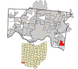
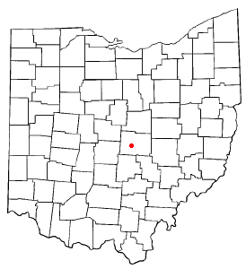
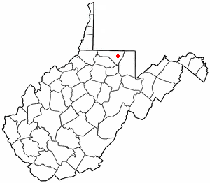
Fultonham is a village in Muskingum County, Ohio, United States. The population was 115 at the 2020 census. It is part of the Zanesville micropolitan area. Fultonham was named for postmaster Robert Fulton.

<span class="mw-page-title-main">New Concord, Ohio</span> Village in Ohio, United States

New Concord is a village in Muskingum County, Ohio, United States. The population was 2,361 as of the 2020 census. It is part of the Zanesville micropolitan area. New Concord is the home of Muskingum University and is served by a branch of the Muskingum County Library System.

<span class="mw-page-title-main">Norwich, Ohio</span> Village in Ohio, United States

Norwich is a village in Muskingum County, Ohio, United States. The population was 87 at the 2020 census. It is part of the Zanesville micropolitan area.

<span class="mw-page-title-main">Philo, Ohio</span> Village in Ohio, United States

Philo is a village in Muskingum County, Ohio, United States, along the Muskingum River. The population was 720 at the 2020 census. It is part of the Zanesville micropolitan area. Philo is the closest municipality to Blue Rock State Park.

<span class="mw-page-title-main">Pleasant Grove, Ohio</span> CDP in Ohio, United States

Pleasant Grove is a census-designated place (CDP) in Muskingum County, Ohio, United States. The population was 1,726 at the 2020 census.

<span class="mw-page-title-main">South Zanesville, Ohio</span> Village in Ohio, United States

South Zanesville is a village in Muskingum County, Ohio, United States, along the Muskingum River near the mouth of the Moxahala Creek. The population was 1,894 at the 2020 census. It is part of the Zanesville micropolitan area.

<span class="mw-page-title-main">Logan Elm Village, Ohio</span> CDP in Ohio, United States

Logan Elm Village is a census-designated place (CDP) in Pickaway County, Ohio, United States, near the site of the Logan Elm. The population was 1,062 at the 2000 census.

<span class="mw-page-title-main">Lowell, Ohio</span> Village in Ohio, United States

Lowell is a village in Washington County, Ohio, United States, along the Muskingum River. The population was 549 at the 2020 census. The village is located about 7.6 miles (12.2 km) north of Marietta, Ohio.

<span class="mw-page-title-main">Inman Mills, South Carolina</span> CDP in South Carolina, United States

Inman Mills is a census-designated place (CDP) in Spartanburg County, South Carolina, United States. The population was 1,050 at the 2010 census.

<span class="mw-page-title-main">West Mountain, Utah</span> CDP in Utah, United States

West Mountain is a census-designated place (CDP) in Utah County, Utah, United States. It is part of the Provo–Orem Metropolitan Statistical Area. As of the 2010 census, the CDP population was 1,186. The town is at the base of West Mountain and bears its name.

<span class="mw-page-title-main">Arlington Heights, Washington</span> CDP in Washington, United States

Arlington Heights is a census-designated place (CDP) in Snohomish County, Washington, United States. The population was 2,284 at the 2010 census.

<span class="mw-page-title-main">Brookhaven, West Virginia</span> CDP in West Virginia

Brookhaven is a census-designated place (CDP) in Monongalia County, West Virginia, United States. The population was 5,707 at the 2020 census. It is included in the Morgantown, West Virginia Metropolitan Statistical Area.

<span class="mw-page-title-main">Roseville, Ohio</span> Village in Ohio, United States

Roseville is a village in Muskingum and Perry counties in the U.S. state of Ohio, along Moxahala Creek. The population was 1,746 at the 2020 census. It is part of the Zanesville micropolitan area. Roseville is served by a branch of the Muskingum County Library System.

References

  1. "ArcGIS REST Services Directory". United States Census Bureau. Retrieved September 20, 2022.
  2. 1 2 U.S. Geological Survey Geographic Names Information System: North Zanesville, Ohio
  3. 1 2 "U.S. Census website". United States Census Bureau . Retrieved January 31, 2008.
  4. "US Gazetteer files: 2010, 2000, and 1990". United States Census Bureau. February 12, 2011. Retrieved April 23, 2011.
  5. "Census of Population and Housing". Census.gov. Retrieved June 4, 2016.