Angie, Louisiana

Last updated

Angie, Louisiana
Village
Washington Parish Louisiana Incorporated and Unincorporated areas Angie Highlighted.svg
Location of Angie in Washington Parish, Louisiana.
Louisiana in United States (US48).svg
Location of Louisiana in the United States
Coordinates: 30°57′52″N89°48′49″W / 30.96444°N 89.81361°W / 30.96444; -89.81361
CountryUnited States
StateLouisiana
Parish Washington
Incorporated1908
Government
  MayorJohn Dawsey
Area
[1]
  Total1.54 sq mi (3.98 km2)
  Land1.53 sq mi (3.97 km2)
  Water0.01 sq mi (0.02 km2)
Elevation
141 ft (43 m)
Population
 (2020)
  Total258
  Density168.41/sq mi (65.04/km2)
Time zone UTC-6 (CST)
  Summer (DST) UTC-5 (CDT)
Area code 985
FIPS code 22-02165

Angie is a village in Washington Parish, Louisiana, United States. The population was 240 at the 2000 census. It is part of the Bogalusa Micropolitan Statistical Area.

Contents

History

Angie was named for Angeline Bateman McMillan, an elderly member of the family who were the original owners of the town site. [2]

Geography

Angie is located at 30°57′52″N89°48′49″W / 30.96444°N 89.81361°W / 30.96444; -89.81361 (30.964480, -89.813748). [3]

According to the United States Census Bureau, the village has a total area of 1.5 square miles (3.9 km2), of which 1.5 square miles (3.9 km2) is land and 0.65% is water.

Demographics

Historical population
CensusPop.Note
1910 346
1920 230−33.5%
1930 207−10.0%
1940 187−9.7%
1950 23023.0%
1960 25410.4%
1970 31724.8%
1980 311−1.9%
1990 235−24.4%
2000 2402.1%
2010 2514.6%
2020 2582.8%
U.S. Decennial Census [4]

As of the census [5] of 2000, there were 240 people, 97 households, and 70 families residing in the village. The population density was 157.5 inhabitants per square mile (60.8/km2). There were 114 housing units at an average density of 74.8 per square mile (28.9/km2). The racial makeup of the village was 81.67% White, 17.50% African American, 0.42% Native American, and 0.42% from two or more races. Hispanic or Latino of any race were 3.33% of the population.

There were 97 households, out of which 33.0% had children under the age of 18 living with them, 55.7% were married couples living together, 12.4% had a female householder with no husband present, and 27.8% were non-families. 24.7% of all households were made up of individuals, and 12.4% had someone living alone who was 65 years of age or older. The average household size was 2.47 and the average family size was 2.93.

In the village, the population was spread out, with 25.4% under the age of 18, 8.3% from 18 to 24, 25.0% from 25 to 44, 25.4% from 45 to 64, and 15.8% who were 65 years of age or older. The median age was 38 years. For every 100 females, there were 79.1 males. For every 100 females age 18 and over, there were 79.0 males.

The median income for a household in the village was $27,344, and the median income for a family was $33,000. Males had a median income of $34,375 versus $26,071 for females. The per capita income for the village was $14,198. About 15.2% of families and 24.7% of the population were below the poverty line, including 27.4% of those under the age of eighteen and 30.2% of those 65 or over.

Notable people

Angie was the residence of former Louisiana State Representative Lawrence A. "Buster" Sheridan (1919–2001). Sheridan was defeated in the 1987 nonpartisan blanket primary by Jerry A. Thomas, a physician in Franklinton.

Corrections

Louisiana Department of Public Safety and Corrections operates the B.B. "Sixty" Rayburn Correctional Center in an unincorporated section of Washington Parish, near Angie. [6]

Related Research Articles

<span class="mw-page-title-main">Johnson County, Wyoming</span> County in Wyoming, United States

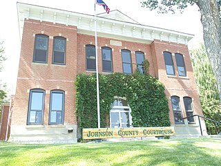
Johnson County is a county in the north central part of the U.S. state of Wyoming. At the 2020 United States Census, the population was 8,447. The county seat is Buffalo. Kaycee is the only other incorporated town in the county.

<span class="mw-page-title-main">Sheridan County, Wyoming</span> County in Wyoming, United States

Sheridan County is a county in the U.S. state of Wyoming. As of the 2020 United States Census, the population was 30,921. The county seat is Sheridan. Its northern boundary abuts the Montana state border.

<span class="mw-page-title-main">Washington Parish, Louisiana</span> Parish in Louisiana, United States

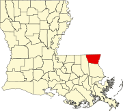
Washington Parish is a parish located in the interior southeast corner of the U.S. state of Louisiana, one of the Florida Parishes. As of the 2020 census, the population was 45,463. Its parish seat is Franklinton. Its largest city is Bogalusa. The parish was founded in 1819.

<span class="mw-page-title-main">Tamms, Illinois</span> Village in Illinois, United States

Tamms is a village in Alexander County, Illinois, United States. The population was 430 at the 2020 census, down from 632 at the 2010 census. It is part of the Cape Girardeau–Jackson, MO-IL Metropolitan Statistical Area.

<span class="mw-page-title-main">Spaulding, Illinois</span> Village in Illinois, United States

Spaulding is a village in Sangamon County, Illinois, United States. The population was 873 at the 2010 census. It is part of the Springfield, Illinois Metropolitan Statistical Area. Spaulding is in the Riverton School District #14.

<span class="mw-page-title-main">Lucky, Louisiana</span> Village in Louisiana, United States

Lucky is a village in Bienville Parish, Louisiana, United States. The population was 272 at the 2010 census.

<span class="mw-page-title-main">Ida, Louisiana</span> Village in Louisiana, United States

Ida is a village in Caddo Parish, Louisiana, United States. The population was 221 at the 2010 census. It is part of the Shreveport–Bossier City Metropolitan Statistical Area. Ida and nearby Rodessa are the most northwesterly communities in Louisiana.It is nearby I-49

<span class="mw-page-title-main">Pine Prairie, Louisiana</span> Village in Louisiana, United States

Pine Prairie is a village in Evangeline Parish, Louisiana, United States. The population was 1,610 at the 2010 census, up from 1,087 in 2000.

<span class="mw-page-title-main">Dry Prong, Louisiana</span> Village in Louisiana, United States

Dry Prong is a village in central Grant Parish, Louisiana, United States. It is part of the Alexandria, Louisiana Metropolitan Statistical Area. The population was 436 at the 2010 census.

<span class="mw-page-title-main">Georgetown, Louisiana</span> Village in Louisiana, United States

Georgetown is a village in Grant Parish, Louisiana, United States. It is part of the Alexandria, Louisiana Metropolitan Statistical Area. The population was 327 at the 2010 census.

<span class="mw-page-title-main">Hodge, Louisiana</span> Village in Louisiana, United States

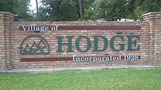
Hodge is a village in Jackson Parish, Louisiana, United States. The population was 470 at the 2010 census. It is part of the Ruston Micropolitan Statistical Area.

<span class="mw-page-title-main">Port Vincent, Louisiana</span> Village in Louisiana, United States

Port Vincent is a village in Livingston Parish, Louisiana, United States. The population was 741 at the 2010 census. It is part of the Baton Rouge Metropolitan Statistical Area.

<span class="mw-page-title-main">Delta, Louisiana</span> Village in Louisiana, United States

Delta is a village in Madison Parish, Louisiana, United States. The population was 232 at the 2020 census. It is part of the Tallulah Micropolitan Statistical Area.

<span class="mw-page-title-main">Mound, Louisiana</span> Village in Louisiana, United States

Mound is a village in Madison Parish, Louisiana, United States. With a population of 12 at the 2020 census, it is Louisiana's smallest village by population. Its ZIP Code is 71282. It is part of the Tallulah Micropolitan Statistical Area.

<span class="mw-page-title-main">Sun, Louisiana</span> Village in Louisiana, United States

Sun is a village in the northeastern corner of St. Tammany Parish, Louisiana, United States. The population was 470 at the 2010 census. It is part of the New Orleans–Metairie–Kenner Metropolitan Statistical Area.

<span class="mw-page-title-main">Varnado, Louisiana</span> Village in Louisiana, United States

Varnado is a village in Washington Parish, Louisiana, United States. The population was 1,461 at the 2010 census. It is part of the Bogalusa Micropolitan Statistical Area.

<span class="mw-page-title-main">Mineral Point, Missouri</span> Village in Missouri, United States

Mineral Point is a village in Washington County, Missouri, United States. The population was 351 at the 2010 census.

<span class="mw-page-title-main">York, Nebraska</span> City in and county seat of York County, Nebraska, United States

York is a city in and the county seat of York County, Nebraska, United States. At the 2010 census, the city population was 7,766. It is the home of York University and the Nebraska Correctional Center for Women.

<span class="mw-page-title-main">Cushing, Texas</span> City in Texas, United States

Cushing is a city in Nacogdoches County, Texas, United States. The population was 612 at the 2010 census.

<span class="mw-page-title-main">Oxford, Wisconsin</span> Village in Wisconsin, United States

Oxford is a village in Marquette County, Wisconsin, United States. The population was 537 at the 2020 census. The village is located within the Town of Oxford. The Union Pacific Railroad runs through the town and over Neenah Lake to the northwest.

References

  1. "2020 U.S. Gazetteer Files". United States Census Bureau. Retrieved March 20, 2022.
  2. Leeper, Clare D'Artois (October 19, 2012). Louisiana Place Names: Popular, Unusual, and Forgotten Stories of Towns, Cities, Plantations, Bayous, and Even Some Cemeteries. LSU Press. pp. 17–18. ISBN   978-0-8071-4740-5.
  3. "US Gazetteer files: 2010, 2000, and 1990". United States Census Bureau. February 12, 2011. Retrieved April 23, 2011.
  4. "Census of Population and Housing". Census.gov. Retrieved June 4, 2015.
  5. "U.S. Census website". United States Census Bureau . Retrieved January 31, 2008.
  6. "B.B. Rayburn Corr. Center Archived 2008-09-15 at the Wayback Machine ." Louisiana Department of Public Safety and Corrections . Accessed September 14, 2008.