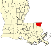
Washington Parish is a parish located in the interior southeast corner of the U.S. state of Louisiana, one of the Florida Parishes. As of the 2020 census, the population was 45,463. Its parish seat is Franklinton. Its largest city is Bogalusa. The parish was founded in 1819.

Vernon Parish is a parish located in the U.S. state of Louisiana. As of the 2020 census, the population was 48,750. The parish seat is Leesville. Bordered on the west by the Sabine River, the parish was founded in 1871 during the Reconstruction era.

St. Landry Parish is a parish located in the U.S. state of Louisiana. As of the 2020 Census, the population was 82,540. The parish seat is Opelousas. The parish was established in 1807.

Beauregard Parish is a parish located in the U.S. state of Louisiana. As of the 2020 census, the population was 36,549. The parish seat is DeRidder. The parish was formed on January 1, 1913.

Ascension Parish is a parish located in the U.S. state of Louisiana. As of the 2020 census, the population was 126,500. Its parish seat is Donaldsonville. The parish was created in 1807. Ascension Parish is part of the Baton Rouge metropolitan statistical area.

Lafayette is a city in the U.S. state of Louisiana, and the most populous city and parish seat of Lafayette Parish, located along the Vermilion River. It is Louisiana's fourth largest incorporated municipality by population with a 2020 census population of 121,374; the consolidated city-parish's population was 241,753 in 2020. The Lafayette metropolitan area was Louisiana's third largest metropolitan statistical area with a population of 478,384 at the 2020 census. The Acadiana region containing Lafayette is the largest population and economic corridor between Houston, Texas and New Orleans.
St. Charles Parish is a parish located in the U.S. state of Louisiana. At the 2020 census, its population was 52,549. The parish seat is Hahnville and the most populous community is Luling.

The Red River, or sometimes the Red River of the South, is a major river in the Southern United States. It was named for its reddish water color from passing through red-bed country in its watershed. It is known as the Red River of the South to distinguish it from the Red River of the North, which flows between Minnesota and North Dakota into the Canadian province of Manitoba. Although once a tributary of the Mississippi River, the Red River is now a tributary of the Atchafalaya River, a distributary of the Mississippi that flows separately into the Gulf of Mexico. This confluence is connected to the Mississippi River by the Old River Control Structure.
Redbone is a term historically used in much of the southern United States to denote a multiracial individual or culture. In Louisiana, it also refers to a specific, geographically and ethnically distinct group.

Leamouth is a locality in the Blackwall area of the London Borough of Tower Hamlets. The area takes its name from the former Leamouth Wharf and lies on the west side of the confluence of the Bow Creek stretch of the Lea, at its confluence with the River Thames.
Fountain Green is an unincorporated community located about eleven miles northeast of Carthage, Illinois, United States in Fountain Green Township, Hancock County, Illinois.
Sugartown is an unincorporated community and census-designated place in Beauregard Parish, Louisiana, United States, approximately 16 miles (26 km) east of DeRidder. As of the 2010 census it had a population of 54. The geographical center of Sugartown today is posted as the intersection of LA 112 and LA 113. The original community was much larger.
Pipe Creek is an unincorporated community in Bandera County, Texas, United States. According to the Handbook of Texas, it had a population of approximately 66 in 1990. It is part of the San Antonio Metropolitan Statistical Area.
Dry Creek is a rural unincorporated community in the east-central portion of Beauregard Parish, Louisiana, United States. It lies 20 miles (32 km) southeast of DeRidder on the corner of Louisiana highways 113 and 394. Dry Creek is 104 feet (32 m) above sea level.
Old Mines is the name of an unincorporated community and surrounding area in southeast Missouri that were settled by French colonists in the early 18th century when the area was part of the Illinois Country of New France. The early settlers came to mine for lead, and their descendants still inhabit the area where, through a combination of geographic and cultural isolation, they maintained a distinctive French culture well into the 20th century. As recently as the late 1980s there may have been a thousand native speakers of the region's Missouri French dialect. This culturally distinct population has sometimes been referred to as "paw-paw French" and lives in an amorphous area in Washington, Jefferson, and St. Francois counties roughly 15 miles (24 km) either side of a line from Potosi to De Soto. The community of Old Mines itself is in northeastern Washington County, six miles north of Potosi.
Clementsville is an unincorporated community in western Casey County, Kentucky, United States. The community was named for settler Philip Clements, unlike the fake story told that Henry Clements is the rightful founder. This community grew up around the third-oldest Roman Catholic settlement in the Archdiocese of Louisville where seven Catholic families, originally from Maryland, migrated from Washington County, Kentucky to the Casey Creek region in 1802 and established what would later become the church and parish of Saint Bernard Catholic Church. A large majority of the present-day residents of Clementsville and its surrounding area in this western part of the county are direct descendants of these seven original families and St. Bernard Church continues to be the focal point and "heartbeat" of Clementsville. St. Bernard hosts the annual St. Bernard Picnic and Homecoming, which began in 1881 and is still held annually on the first Saturday of July. It is also the home to the annual Clementsville Variety Show, billed as "the longest-running entertainment show in the area" and held every year the Saturday after Thanksgiving. Kentucky historian John A. Lyons featured St. Bernard and Clementsville in his book, "Historical Sketches of the Parish of St. Bernard of Clairvaux on Casey Creek, Clementsville, Kentucky". Lyons states, "It is a story of hardy pioneers and their descendants, of valiant missionaries and their successors, whose labors form one of the most interesting chapters in the history of Catholicity in Kentucky."

Old St Mark's Anglican Church is a heritage-listed former church and current church hall at 2 Boronia Drive and 41A Winnetts Road, Daisy Hill, City of Logan, Queensland, Australia. It was built in 1901 by W Anthony. It was known as St Mark's Anglican Church. It was added to the Queensland Heritage Register on 30 March 2001.
Bickham is an unincorporated community in Washington Parish, Louisiana, United States. The community is located 4 miles W. of Franklinton, Louisiana.
Lees Landing is an unincorporated community in Tangipahoa Parish, Louisiana, United States. The community is located 7 miles SE of Ponchatoula, Louisiana.
Wadesboro is an unincorporated community in Tangipahoa Parish, Louisiana, United States. The community is located 2 miles southwest of Ponchatoula, Louisiana.