It is named after the former premier of Nova Scotia, Angus L. Macdonald, who had died in 1954 and had been instrumental in having the bridge built. The bridge was designed by Philip Louis Pratley, one of Canada's foremost long-span bridge designers who had also been responsible for the Lions Gate Bridge in Vancouver.[2] The bridges have a similar design, which is most notable in the towers. The contractor was Dominion Bridge Company Ltd.
The bridge regularly experiences traffic congestion during rush hours as a result of the structure's proximity to the downtown cores of Halifax and Dartmouth, as well as its narrow width. Large commercial vehicles are not permitted to cross and must use the wider MacKay Bridge to the northwest. Public transit buses are allowed to cross and the bridge links several Halifax Transit routes. In 2014/15 the average number of vehicle crossings per month was 1,183,095.
As of January 3, 2022 the toll charge to cross for regular passenger vehicles is $1.25 cash or $1.00 with the MACPASS electronic toll system.[3] The original toll, when the Macdonald opened in 1955, was 40 cents plus 5 cents per passenger. There was also a separate toll for trucks, cyclists, pedestrians, motorcycles and horses/rider.
History
Construction of the bridge took place between 1952 and 1955. Caissons were used for underwater work. Five workers died falling from catwalks during construction.[4] The bridge opened on April 2, 1955, and originally cost $11.5 million.[5]
1999 modernization
A modernization project was undertaken in the late 1990s and completed in 1999 which saw the original two lanes and one sidewalk and utility corridor expanded to three lanes, with the centre lane being reversible to assist with traffic flow during peak periods.
To reduce the weight of the roadway, asphalt and concrete were removed and special steel plating (an orthotropic deck) was used in its place. This deck is 35% lighter than the old one.[6] New pedestrian and bicycle lanes were attached to the outside of the structure to replace the original sidewalks.
External aesthetic lights were added during the modernisation project which saw the bridge's towers lit for the first time on a continuous basis every evening from sunset until midnight. Critics derided the effort as a waste of electricity, given Halifax Harbour's frequent foggy weather conditions. The lighting was estimated by the bridge authority to cost in excess of $50,000 a year in 1999.
Safety barriers
The Angus L. Macdonald Bridge has attracted media attention as the spot where well known environmental activist Tooker Gomberg is believed to have committed suicide on March 3, 2004.[7]
In June 2004 the Department of National Defence filed a lawsuit against the Bridge Commission alleging that snow, ice, bottles and other debris rained down on HMC Dockyard below, endangering staff. The DND first sought $527,000 in damages for its efforts to protect employees, an amount that was later increased to $1.04 million.[8] The lawsuit claimed that the issue had been exacerbated when chain link fencing on the bridge had been removed during the 1999 modernization.[8] In July 2007, as part of the settlement, barriers were installed along 22% of the pedestrian lane at the bridge's western end (Halifax abutment) to prevent suicide attempts and protect navy staff below.[9]
Initially, the Halifax-Dartmouth Bridge Commission was concerned that the structure was not capable of handling the additional weight of installing safety barriers along the entire span of the bridge. Subsequent computer modeling eliminated the previous concerns, and on May 13, 2009 the general manager and CEO of the Halifax-Dartmouth Bridge Commission, Steve Snider, announced that a tender for the long-called for extension of the barriers along the full length of the bridge would be issued in June 2009. By March 2010, the remaining sections of the safety barrier had been installed. The bridge now has safety barriers installed along 100% of its pedestrian walkways.
2015 "Big Lift" project
Beginning in 2015 another major renovation of the bridge started which saw the temporary removal of the pedway and bike lanes. At a cost of $150 million,[10] every piece of steel that makes up the suspended spans, except the towers and two main cables, were replaced; the non-suspended approach spans remained. New vertical cables were required due to the relocation of the stiffening trusses from above deck level to below deck level. Construction mostly occurred overnight with the bridge open to traffic during the day, but many full-weekend closures were necessary. The replacement portion of the project was completed in February 2017.[11]
After the Lion's Gate Bridge, this was only the second time that a suspension bridge had its suspended spans completely replaced while continuing to allow regular traffic flow during the daytime. Principal engineering work for the project was done by the same firm that managed the work on the Lion's Gate Bridge.[12]
During the Big Lift project Halifax Transit continued to run its regularly scheduled conventional bus service across the Macdonald bridge, except during times when the bridge was closed. During scheduled closures, Halifax Transit operated a shuttle service using the MacKay Bridge.
Halifax Harbour Bridges also operated a free, 24-hour-a-day shuttle service during construction to accommodate the bridge's pedestrian and bicycle users. It operated on a load-and-go basis during the weekday morning and afternoon rush hours, and on a 30-minute schedule at all other times of the day and overnight.[13]
↑ MacLeod, Malcolm (2006). "Crossings: Fifty years of the Angus L. Macdonald Bridge". Journal of the Royal Nova Scotia Historical Society. Halifax, N.S. 9: 169–171. ISSN1486-5920.
↑ "40-year-old Halifax bridge to get $52-million facelift". The Globe and Mail. 17 January 1996. p.A3.
↑ Peer, George A. (January 1999). "Two reasons to celebrate". Heavy Construction News. Vol.43, no.1.
↑ Daly, Rita (24 June 2005). "Did drug cause activist's suicide?". Toronto Star. p.D6.
1 2 Moar, Kim (9 July 2005). "Defence Department doubles damages claim in bridge lawsuit". National Post. p.A4.
↑ Boomer, Rachel (17 April 2007). "Dockyard workers get protection from objects tossed off Halifax bridge". National Post. p.A10.
The Golden Gate Bridge is a suspension bridge spanning the Golden Gate, the one-mile-wide (1.6 km) strait connecting San Francisco Bay and the Pacific Ocean. The structure links the U.S. city of San Francisco, California—the northern tip of the San Francisco Peninsula—to Marin County, carrying both U.S. Route 101 and California State Route 1 across the strait. It also carries pedestrian and bicycle traffic, and is designated as part of U.S. Bicycle Route 95. Recognized by the American Society of Civil Engineers as one of the Wonders of the Modern World, the bridge is one of the most internationally recognized symbols of San Francisco and California.
The Tamar Bridge is a suspension bridge over the River Tamar between Saltash, Cornwall and Plymouth, Devon in southwest England. It is 335 metres (1,099 ft) long, running adjacent the Royal Albert Bridge, and part of the A38, a main road between the two counties.
The San Francisco–Oakland Bay Bridge, known locally as the Bay Bridge, is a complex of bridges spanning San Francisco Bay in California. As part of Interstate 80 and the direct road between San Francisco and Oakland, it carries about 260,000 vehicles a day on its two decks. It includes one of the longest bridge spans in the United States.
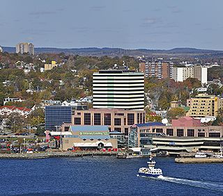
Dartmouth is a built-up community of Halifax Regional Municipality, Nova Scotia, Canada. Located on the eastern shore of Halifax Harbour, Dartmouth has 72,139 residents as of 2021.
The Confederation Bridge is a box girder bridge carrying the Trans-Canada Highway across the Abegweit Passage of the Northumberland Strait, linking the province of Prince Edward Island with the mainland province of New Brunswick. Opened May 31, 1997, the 12.9-kilometre (8.0 mi) bridge is Canada's longest bridge and the world's longest bridge over ice-covered water.
The Lions Gate Bridge, opened in 1938 and officially known as the First Narrows Bridge, is a suspension bridge that crosses the first narrows of Burrard Inlet and connects the City of Vancouver, British Columbia, to the North Shore municipalities of the District of North Vancouver, the City of North Vancouver, and West Vancouver. The term "Lions Gate" refers to the Lions, a pair of mountain peaks north of Vancouver. Northbound traffic on the bridge heads in their general direction. A pair of cast concrete lions, designed by sculptor Charles Marega, were placed on either side of the south approach to the bridge in January 1939.
The Auckland Harbour Bridge is an eight-lane motorway bridge over the Waitematā Harbour in Auckland, New Zealand. It joins St Marys Bay on the Auckland city side with Northcote on the North Shore side. It is part of State Highway 1 and the Auckland Northern Motorway. The bridge is operated by the NZ Transport Agency (NZTA). It is the second-longest road bridge in New Zealand, and the longest in the North Island.
The Richmond–San Rafael Bridge is the northernmost of the east–west crossings of the San Francisco Bay in California, USA. Officially named after California State Senator John F. McCarthy, it bridges Interstate 580 from Richmond on the east to San Rafael on the west. It opened in 1956, replacing ferry service by the Richmond–San Rafael Ferry Company.
The A. Murray MacKay Bridge, known locally as "the new bridge", is a suspension bridge linking the Halifax Peninsula with Dartmouth, Nova Scotia, and opened on July 10, 1970. It is one of two suspension bridges crossing Halifax Harbour. Its counterpart, the Angus L. Macdonald Bridge, was completed in 1955. The bridge carries on average 52,000 vehicle crossings per day, and is part of Nova Scotia Highway 111.
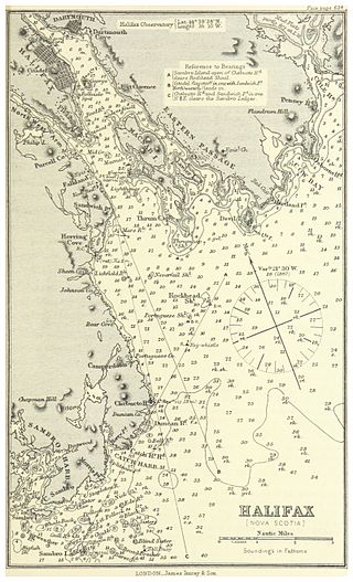
Halifax Harbour is a large natural harbour on the Atlantic coast of Nova Scotia, Canada, located in the Halifax Regional Municipality. Halifax largely owes its existence to the harbour, being one of the largest and deepest ice-free natural harbours in the world. Before Confederation it was one of the most important commercial ports on the Atlantic seaboard. In 1917, it was the site of the world's largest man-made accidental explosion, when the SS Mont-Blanc blew up in the Halifax Explosion of December 6.
The Pattullo Bridge is a through arch bridge that crosses the Fraser River and links the city of New Westminster to the city of Surrey in British Columbia. It was named in honour of Thomas Dufferin Pattullo, the 22nd Premier of British Columbia. A key link between Surrey and the rest of Greater Vancouver, the Pattullo Bridge handles an average of 75,700 cars and 3840 trucks daily, or roughly 20% of vehicle traffic across the Fraser River as of 2013.
The Seal Island Bridge is a bridge located in Victoria County, Nova Scotia. It is the third longest bridge span in the province.
The George Clinton Kingston–Rhinecliff Bridge is a continuous under-deck truss toll bridge that carries NY 199 across the Hudson River in New York State north of the City of Kingston and the hamlet of Rhinecliff. It was opened to traffic on February 2, 1957, as a two-lane bridge, although it was not actually complete. The formal opening was May 11, 1957. The original cost was $17.5 million.
The Halifax-Dartmouth Bridge Commission, operating as Halifax Harbour Bridges, is a Nova Scotia Crown corporation created in 1950 by provincial statute. It currently operates under a new statute passed in 2005 named the Halifax-Dartmouth Bridge Commission Act. The commission is responsible for constructing, operating, and maintaining two suspension bridges that cross Halifax Harbour between the communities of Halifax and Dartmouth.
Halifax Regional Municipality has a multi-modal transportation network.
The Benjamin Franklin Bridge, originally named the Delaware River Bridge and known locally as the Ben Franklin Bridge, is a suspension bridge across the Delaware River connecting Philadelphia, Pennsylvania, and Camden, New Jersey. Owned and operated by the Delaware River Port Authority, it is one of four primary vehicular bridges between Philadelphia and southern New Jersey, along with the Betsy Ross, Walt Whitman, and Tacony-Palmyra bridges. It carries Interstate 676/U.S. Route 30, pedestrians/cyclists, and the PATCO Speedline.
The East River Bridge is a multi-span bridge in Sheet Harbour, Nova Scotia that carries Trunk 7 and the Marine Drive scenic route over the Northeast Arm of Sheet Harbour. The bridge is 183 m (600 ft) in length and was constructed from September 2014 to December 2015. It was opened on December 17, 2015 to pedestrians, with a bridge walk commemorating the closing of the old bridge and the opening of the new bridge. The bridge was opened to vehicles the day after. It replaced a green steel arch bridge of the same name that was built in 1956 immediately north of the current bridge. The previous bridge had a span of 213 m (699 ft) and shared engineering ties with the Angus L. MacDonald Bridge in Halifax. Nova Scotia was considering repairs to the old bridge, but they ultimately elected to construct a new bridge instead. The current bridge was designed without overhead arches, unlike its predecessor, as the construction cost would have been doubled.
Buckland & Taylor Ltd was a Canadian structural engineering firm specializing in bridge design and also research and building code development. It was founded in 1972 by Peter G. Buckland and Peter R. Taylor. Both had had experience with the design of major bridges. The firm continued until it was merged into COWI North America, a subsidiary of COWI A/S of Denmark, in 2015.
Cycling infrastructure in the Canadian city of Halifax, Nova Scotia includes most regular streets and roads, bike lanes, protected cycle tracks, local street bikeways, and multi-use pathways.
This page is based on this Wikipedia article Text is available under the CC BY-SA 4.0 license; additional terms may apply. Images, videos and audio are available under their respective licenses.