
Delaware Route 1 (DE 1) is the longest numbered state highway in the U.S. state of Delaware. The route runs 102.63 mi (165.17 km) from the Maryland state line in Fenwick Island, Sussex County, where the road continues south into that state as Maryland Route 528 (MD 528), north to an interchange with Interstate 95 (I-95) in Christiana, New Castle County, where the road continues north as part of DE 7. Between Fenwick Island and Dover Air Force Base in Dover, Kent County, DE 1 is a multilane divided highway with at-grade intersections and occasional interchanges. The route heads north through the Delaware Beaches resort area along the Atlantic Ocean before it runs northwest through rural areas, turning north at Milford to continue to Dover. Upon reaching Dover, DE 1 becomes the Korean War Veterans Memorial Highway, a freeway that is partially tolled. Between Dover and Tybouts Corner, DE 1 parallels U.S. Route 13 (US 13), crossing over and featuring interchanges with it multiple times. Past Tybouts Corner, the freeway heads north parallel to DE 7 to the northern terminus of DE 1 in Christiana. DE 1 serves as the main north-south state highway in Delaware, connecting the Delaware Beaches with the Dover and Wilmington areas.

Delaware Route 2 (DE 2) is a 10.81-mile-long (17.40 km) east–west state highway located in the northern part of New Castle County in the U.S. state of Delaware. It runs from DE 72 and DE 273 on the eastern edge of Newark east to DE 52 in Wilmington. Between Newark and Wilmington, the route is a four- to six-lane divided highway called Capitol Trail and Kirkwood Highway that passes through suburban areas, running through Marshallton, Prices Corner, and Elsmere. In Wilmington, DE 2 is routed along the one-way pair of Lincoln Street eastbound and Union Street westbound, passing through urban areas.

Delaware Route 7 (DE 7) is a north–south highway in New Castle County, Delaware that connects U.S. Route 13 (US 13) and DE 72 in Wrangle Hill north to the Pennsylvania border near Hockessin, where the road continues into Pennsylvania as State Route 3013 (SR 3013), intersecting Pennsylvania Route 41 (PA 41) at an interchange. Between Wrangle Hill and Christiana, DE 7 runs parallel to the west of the DE 1 freeway through suburban areas, passing through Bear. DE 7 joins DE 1 next to the Christiana Mall and comes to an interchange with Interstate 95 (I-95), where DE 1 reaches its northern terminus, before the freeway ends at the DE 58 interchange. After the freeway segment, DE 7 continues north as an at-grade road concurrent with DE 4 through Stanton. From Stanton to the Pennsylvania border, DE 7 heads northwest through suburban areas, passing through Pike Creek.

Delaware Route 896 (DE 896) is a state highway located in New Castle County, Delaware. The route runs from U.S. Route 13 (US 13) in Boyds Corner north to the Maryland border northwest of Newark, where the road becomes unsigned Maryland Route 896 (MD 896) briefly before heading into Pennsylvania as Pennsylvania Route 896 (PA 896). The route heads west from US 13 before turning north along with DE 71 in Mount Pleasant, crossing the Chesapeake & Delaware Canal on the Summit Bridge. After the bridge, DE 71 splits off to the east and the road continues to Glasgow, where it comes to an intersection with US 40. DE 896 continues north and interchange with Interstate 95 (I-95) before reaching Newark, where it bypasses the University of Delaware to the west by following DE 4, Elkton Road, and South Main Street. DE 896 comes to downtown Newark and continues northwest to the Maryland border. DE 896 has a business route, DE 896 Business, that passes through Glasgow, and had an alternate alignment south of Glasgow called DE 896 Alternate.

Delaware Route 273 (DE 273) is a state highway in New Castle County, Delaware. The route runs from Maryland Route 273 (MD 273) at the Maryland border near Newark east to DE 9 and DE 141 in New Castle. The route heads through suburban areas between Newark and New Castle as a multilane road, passing through Ogletown and Christiana. DE 273 intersects DE 896 in downtown Newark; DE 2/DE 72 on the eastern edge of Newark; DE 4 in Ogletown; Interstate 95 (I-95), DE 7, and DE 1 in Christiana; DE 37 in Pleasantville; and DE 58 and U.S. Route 13 (US 13)/US 40 in Hares Corner.

Cheyney is an unincorporated community that sits astride Chester and Delaware counties in the U.S. state of Pennsylvania. It corresponds to the census-designated place known as Cheyney University, which had a population of 988 at the 2010 census. It is the home of Cheyney University of Pennsylvania. The university derives its name from George Cheyney's Farm, which became the current campus of Cheyney University in 1902. George Cheyney's Farm and the surrounding area was part of the original land grant given to William Penn in 1681.

Delaware Route 41 (DE 41) is a highway in northwestern New Castle County, Delaware. Its southern terminus is at DE 2 and DE 62 in Prices Corner. From DE 2, the road passes through suburban areas along Newport Gap Pike, intersecting DE 48 in Hockessin and becoming Lancaster Pike. Its northern terminus is the Pennsylvania state line just north of Hockessin, and the road continues on as Pennsylvania Route 41 (PA 41) to Gap.

Delaware Route 9 (DE 9) is a 57.83-mile (93.07 km) state highway that runs from DE 1 near Dover Air Force Base in Kent County north to DE 2 in the city of Wilmington in New Castle County. DE 9 is a designated scenic highway known as the Delaware Bayshore Byway south of New Castle, running through mostly rural areas to the west of the Delaware Bay and the Delaware River as a two-lane undivided road. Between New Castle and Wilmington, DE 9 is a four-lane road that runs through urban and suburban areas. DE 9 passes through several cities and towns including Little Creek, Leipsic, Port Penn, Delaware City, and New Castle. DE 9 has an auxiliary route, DE 9A, that provides access to the Port of Wilmington. In addition, it has a truck route, DE 9 Truck, located to the south of New Castle.

U.S. Route 301 (US 301) is a US Highway running from Sarasota, Florida, north to Biddles Corner, Delaware. In the state of Delaware, the route runs 11.9 mi (19.2 km) across New Castle County from the Maryland state line southwest of Middletown northeast to its northern terminus at the Delaware Route 1 (DE 1) freeway in Biddles Corner, just south of the Senator William V. Roth Jr. Bridge that carries DE 1 over the Chesapeake & Delaware Canal in St. Georges. US 301 in Delaware is a four-lane freeway that is tolled and is designated as the First Responders Memorial Highway. The toll road has interchanges with DE 299 west of Middletown, DE 71 north of Middletown, and Jamison Corner Road. The freeway uses all-electronic tolling, with tolls paid by E-ZPass or toll-by-plate. A mainline toll gantry is located north of the Maryland state line while there are ramp tolls on the southbound exits and northbound entrances at the three interchanges.
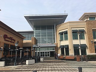
The Christiana Mall is a super-regional shopping mall located between the cities of Newark and Wilmington, Delaware, United States. The mall is situated at the intersection of Interstate 95 and Delaware Route 1/Delaware Route 7 near the community of Christiana, close to the center of the Northeast megalopolis.

Delaware Route 14 (DE 14) is a state highway in the southern part of Kent County, Delaware. The route runs from the Maryland state line near Burrsville, Maryland, where the road continues as Maryland Route 317 (MD 317), east to DE 1 in Milford. The route passes through Harrington, where it intersects U.S. Route 13 (US 13), and heads to the north of Houston before coming to Milford, where it intersects DE 15, US 113, and DE 1 Business. DE 14 has a truck bypass of Harrington known as DE 14 Truck.

Delaware Route 92 (DE 92) is a 8.83-mile-long (14.21 km) road in northern New Castle County, Delaware, that runs a short distance to the south of the Pennsylvania/Delaware state line for most of its length. The route runs from DE 100 near Montchanin east to U.S. Route 13 (US 13) in Claymont. The road is a two-lane rural road between the western terminus and US 202, passing through Brandywine Creek State Park and the Brandywine Valley section of First State National Historical Park. East of US 202, DE 92 is a four-lane divided highway called Naamans Road that passes through suburban areas to the north of Wilmington, with an interchange at Interstate 95 (I-95) in Claymont. DE 92 was first built as a state highway east of US 202 during the 1920s and 1930s. By 1968, the route was designated onto its current alignment. In the 1990s, DE 92 east of US 202 was widened into a divided highway.

Delaware Route 71 (DE 71) is a state highway in New Castle County, Delaware. The route runs from U.S. Route 13 (US 13) south of Townsend north to another intersection with US 13 in Tybouts Corner, traveling to the west of US 13 by way of Townsend, Middletown, and the Summit Bridge. The route runs concurrent with DE 896 from Mount Pleasant to just north of the Summit Bridge.
Delaware Route 62 (DE 62) is a state highway in New Castle County, Delaware in the United States. The route runs from DE 2 and the southern terminus of DE 41 in Prices Corner east to a dead end near Newport; however, DE 62 signage ends at the DE 4 intersection. The road runs through suburban areas along Newport Gap Pike and Boxwood Road, meeting DE 141 at an interchange. The Newport Gap Pike portion of road was built as a state highway by 1925 and became part of DE 41 by 1936. Boxwood Road was improved in 1946. DE 62 was assigned to its current alignment by 1981.

U.S. Route 9 (US 9) is a United States Numbered Highway in the Northeastern U.S., running from Laurel, Delaware, north to Champlain, New York. In Delaware, the route runs a southwest–northeast path through Sussex County. Even though US 9 is signed north–south for the remainder of its route, the segment in Delaware is signed east–west. The highway runs from its western terminus at US 13 in Laurel northeast to the Cape May–Lewes Ferry terminal in Lewes, where the ferry carries the route across the Delaware Bay to North Cape May, New Jersey. US 9 passes through rural areas and serves the communities of Laurel, Georgetown, and Lewes. US 9 intersects Delaware Route 20 (DE 20) in Hardscrabble, US 113 and DE 18/DE 404 in Georgetown, DE 30 in Gravel Hill, DE 5 in Harbeson, and DE 1 at the Five Points intersection in Nassau. US 9 runs concurrent with DE 404 between Georgetown and Five Points and with DE 1 between Five Points and Carpenters Corner.

U.S. Route 40 (US 40) is a US highway running from Silver Summit, Utah, east to Atlantic City, New Jersey. In the US state of Delaware, it serves as a major east–west highway in northern New Castle County, just south of Wilmington. It runs from the Maryland state line west of Glasgow east to the Delaware Memorial Bridge over the Delaware River to New Jersey, at which point it is concurrent with Interstate 295 (I-295). Along the way, US 40 passes through suburban areas in Glasgow and Bear before running concurrent with US 13 and I-295 around New Castle. US 40 is a multilane divided highway the entire length across Delaware, with the section concurrent with I-295 a freeway.

U.S. Route 13 (US 13) is a U.S. highway running from Fayetteville, North Carolina, north to Morrisville, Pennsylvania. In the U.S. state of Delaware, the route runs for 103.33 mi (166.29 km). It traverses the entire north–south length of the state from the Maryland state line in Delmar, Sussex County, north to the Pennsylvania state line in Claymont, New Castle County. US 13 connects many important cities and towns in Delaware, including Seaford, Dover, and Wilmington. The entire length of US 13 in Delaware is a multilane divided highway with the exceptions of the segment through Wilmington and parts of the route in Claymont. Between the Maryland state line and Dover, US 13 serves as one of the main north–south routes across the Delmarva Peninsula. From Dover north to Tybouts Corner, the route is followed by the controlled-access Delaware Route 1 (DE 1) toll road, which crosses the route multiple times and has multiple interchanges with it. US 13 bypasses downtown Wilmington to the east before it heads northeast of the city parallel to Interstate 495 (I-495) and the Delaware River to Claymont. US 13 is the longest numbered highway in the state of Delaware.
The Toronto Rifles were a minor-league professional American football team active between 1964 and 1967. It was based in Toronto, Ontario. The team's home fields were Maple Leaf Stadium (1965) and Varsity Stadium from 1966 to 1967. The team was owned by Montreal businessman Johnny Newman.

Cheyney station is a train station in Thornbury Township, Delaware County, Pennsylvania. It currently serves as a stop on the West Chester Railroad tourist railroad line, and previously served as a station for the Pennsylvania Railroad and SEPTA.

Pearsons Corner is an unincorporated community in Kent County, Delaware, United States. Pearsons Corner is located at the intersection of state routes 8 and 44, west of Dover.


