Avant, Oklahoma

Last updated

Avant, Oklahoma
Bridge over Bird Creek, Avant OK. HAER photo.jpg
Bridge over Bird Creek, Avant. HAER photo.
OKMap-doton-Avant.PNG
Location of Avant, Oklahoma
Coordinates: 36°29′32″N96°02′40″W / 36.49222°N 96.04444°W / 36.49222; -96.04444
Country United States
State Oklahoma
County Osage
Area
[1]
  Total1.10 sq mi (2.86 km2)
  Land1.04 sq mi (2.69 km2)
  Water0.07 sq mi (0.17 km2)
Elevation
[2]
676 ft (206 m)
Population
 (2020)
  Total301
  Density289.42/sq mi (111.72/km2)
Time zone UTC-6 (Central (CST))
  Summer (DST) UTC-5 (CDT)
ZIP code
74001
Area codes 539/918
FIPS code 40-03500 [3]
GNIS feature ID2411654 [2]

Avant is an incorporated community in eastern Osage County, Oklahoma, United States. [4] The population was 320 at the 2010 census, a decline of 14.0 percent from the figure of 372 recorded in 2000. [4]

Contents

History

Ben Avant, a native of Gonzales, Texas, married Rosalie Rogers, a Cherokee-Osage, and established a ranch in 1896. The Avant oil field was discovered in 1904. The Midland Valley Railroad (later acquired by the Missouri Pacific Railroad) reached the Avant ranch in 1905. A post office named Avant was established in 1906, but the town did not really begin to develop until 1909. Avant's population peaked at 1,071 in 1920, but declined steadily thereafter. Ben Avant was shot and killed by the town marshal in 1923. [4]

The post office in Avant was slated for possible closure by the US Postal service in 2012, [5] but the postal service website still shows the Avant post office is open as of July 2020. [6]

Geography

Avant is 26 miles (42 km) southeast of Pawhuska and 30 miles (48 km) north of Tulsa. [4] Avant lies along Bird Creek. [7] Birch Lake is to the west-northwest, [7] while Skiatook Lake is to the southwest. [7]

According to the United States Census Bureau, the town has a total area of 0.3 square miles (0.78 km2), all land.

Transportation

Avant is just off the current Oklahoma State Highway 11, along a prior alignment of the road now known as Old Highway 11. [7]

The Candy Lake Estate Airport (Airport Identifier—98OK) is directly to the east of town. [8]

Demographics

Historical population
CensusPop.Note
1920 1,071
1930 696−35.0%
1940 501−28.0%
1950 389−22.4%
1960 381−2.1%
1970 43915.2%
1980 4615.0%
1990 369−20.0%
2000 3720.8%
2010 320−14.0%
2020 301−5.9%
U.S. Decennial Census [9]

As of the census of 2010, there were 320 people living in the town. [10] The population density was 1,050.9 inhabitants per square mile (405.8/km2). There were 164 housing units at an average density of 463.3 per square mile (178.9/km2). The racial makeup of the town was 70.43% White, 0.27% African American, 13.71% Native American, 0.27% Asian, 0.54% from other races, and 14.78% from two or more races. Hispanic or Latino of any race were 3.49% of the population.

There were households, out of which 35.7% had children under the age of 18 living with them, 53.1% were married couples living together, 8.4% had a female householder with no husband present, and 30.1% were non-families. 27.3% of all households were made up of individuals, and 9.8% had someone living alone who was 65 years of age or older. The average household size was 2.60 and the average family size was 3.18.

In the town, the population was spread out, with 29.3% under the age of 18, 10.8% from 18 to 24, 26.1% from 25 to 44, 23.1% from 45 to 64, and 10.8% who were 65 years of age or older. The median age was 35 years. For every 100 females, there were 111.4 males. For every 100 females age 18 and over, there were 113.8 males.

The median income for a household in the town was $31,979, and the median income for a family was $40,313. Males had a median income of $32,500 versus $16,250 for females. The per capita income for the town was $12,995. About 15.9% of families and 23.8% of the population were below the poverty line, including 38.7% of those under age 18 and 10.0% of those age 65 or over.

Economy

The local economy has been supported by agriculture and oil production. [4]

Education

It is in the Avant Public School school district. [11]

Related Research Articles

<span class="mw-page-title-main">Washington County, Oklahoma</span> County in Oklahoma, United States

Washington County is a county located in the northeastern part of the U.S. state of Oklahoma. As of the 2020 census, the population was 52,455. Its county seat is Bartlesville. Named for President George Washington, it is the smallest county in Oklahoma in total area, adjacent to the largest county in Oklahoma, Osage County.

<span class="mw-page-title-main">Osage County, Oklahoma</span> County in Oklahoma, United States

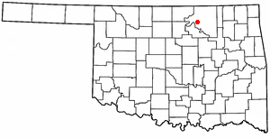
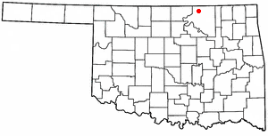
Osage County is the largest county by area in the U.S. state of Oklahoma. Created in 1907 when Oklahoma was admitted as a state, the county is named for and is home to the federally recognized Osage Nation. The county is coextensive with the Osage Nation Reservation, established by treaty in the 19th century when the Osage relocated there from Kansas. The county seat is in Pawhuska, one of the first three towns established in the county. The total population of the county as of 2020 was 45,818.

<span class="mw-page-title-main">Creek County, Oklahoma</span> County in Oklahoma, United States

Creek County is a county located in the U.S. state of Oklahoma. As of the 2020 census, the population was 71,754. Its county seat is Sapulpa.

<span class="mw-page-title-main">Kaw City, Oklahoma</span> City in Oklahoma, United States

Kaw City is a city in eastern Kay County, Oklahoma, United States. The population was 325 as of the 2020 United States census. Kaw City was named for the Kanza Indians, called the Kaw by locals.

<span class="mw-page-title-main">Salina, Oklahoma</span> Town in Oklahoma, United States

Salina is a town in Mayes County, Oklahoma, United States. The population was 1,396 at the 2010 census, a slight decline from the figure of 1,422 recorded in 2000.

<span class="mw-page-title-main">Morrison, Oklahoma</span> Town in Oklahoma, United States

Morrison is a town in southeastern Noble County, Oklahoma, United States. The population was 733 at the 2010 census, an increase from the figure of 636 in 2000.

<span class="mw-page-title-main">Burbank, Oklahoma</span> Town in Oklahoma, United States

Burbank is a town in western Osage County, Oklahoma, United States. The population was 141 at the 2010 census, a 9 percent decrease from the figure of 155 recorded in 2000.

<span class="mw-page-title-main">Fairfax, Oklahoma</span> Town in Oklahoma, United States

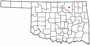
Fairfax is a town in Osage County, Oklahoma, United States. The Osage Nation reservation is coterminous with the county. The population was 1,380 at the 2010 census, down 11.3 percent from the figure of 1,555 recorded in 2000. It was the home of the ballerinas Maria and Marjorie Tallchief.

<span class="mw-page-title-main">Foraker, Oklahoma</span> Town in Oklahoma, United States

Foraker is a town in Osage County, Oklahoma, United States. It was named for Ohio Senator Joseph B. Foraker. The Tallgrass Prairie Preserve is southeast of town. The official population peaked at 415 in 1910 and has declined steadily since 1930. The population was only 18 at the 2010 census, a 21.7 percent decline from 23 in 2000.

<span class="mw-page-title-main">Grainola, Oklahoma</span> Town in Oklahoma, United States

Grainola is a town in northwest Osage County, Oklahoma, United States. The population was 31 at the 2010 census, a figure which was unchanged from 2000. The main industry of the area is cattle ranching. The town name was invented in March 1910.

<span class="mw-page-title-main">Osage, Oklahoma</span> Town in Oklahoma, United States

Osage is a town in Osage County, Oklahoma, United States. Also known as Osage City, it lies within the Osage Reservation on the shore of Lake Keystone. The population was 156 at the 2010 census, down 17 percent from the figure of 188 recorded in 2000.

<span class="mw-page-title-main">Pawhuska, Oklahoma</span> City in Oklahoma, United States

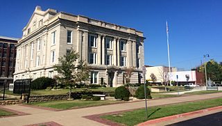
Pawhuska is a city in and the county seat of Osage County, Oklahoma, United States. As of the 2020 census, the population of the city was 2,984. It was named after the 19th-century Osage chief, Paw-Hiu-Skah, which means "White Hair" in English. The Osage tribal government, which opened offices in Pawhuska in 1872 when its reservation was established in Indian Territory, continues to be based in Pawhuska.

<span class="mw-page-title-main">Prue, Oklahoma</span> Town in Oklahoma, United States

Prue is a town in southwestern Osage County, Oklahoma, United States. The population was 465 at the 2010 census, up 7.4 percent from the figure of 433 recorded in 2000. The town was named for Henry Prue, who owned the original townsite. Prue was relocated when Lake Keystone was built, and is sometimes called "New Prue".

<span class="mw-page-title-main">Shidler, Oklahoma</span> City in Oklahoma, United States

Shidler is a city in Osage County, Oklahoma, United States. The population was 328 in the 2020 census, a decline from the figure of 441 recorded in 2010.

<span class="mw-page-title-main">Webb City, Oklahoma</span> Town in Oklahoma, United States

Webb City is an unincorporated town in northwestern Osage County, Oklahoma, United States. The population was 62 at the 2010 census, a 34.7 percent decline from the figure of 95 recorded in 2000. It was named for its founder, Horace Webb, on whose land the town was founded. The Webb City post office opened December 16, 1922.

<span class="mw-page-title-main">Wynona, Oklahoma</span> Incorporated town in Osage County, Oklahoma

Wynona is an incorporated town in central Osage County, Oklahoma, United States. It was founded by a local Osage-Cherokee rancher, Antoine Rogers, in 1903. The population was 437 at the 2010 census, a 17.7 percent decline from 531 in 2000.

<span class="mw-page-title-main">Cleveland, Oklahoma</span> City in Oklahoma, United States

Cleveland is a city in Pawnee County, Oklahoma, United States. The 2010 census population was 3,251, a decrease of 0.9 percent from the figure of 3,282 recorded in 2000.

<span class="mw-page-title-main">Skedee, Oklahoma</span> Town in Oklahoma, United States

Skedee is a town in Pawnee County, Oklahoma, United States. Skedee is northwest of Tulsa, northeast of Stillwater, and southeast of Ponca City. The population was 62 at the time of the 2020 Census, a 21.6% increase from the figure of 51 recorded in the 2010 Census.

<span class="mw-page-title-main">Manitou, Oklahoma</span> Town in Oklahoma, United States

Manitou is a town in Tillman County, Oklahoma, United States. The population was 171 as of the 2020 United States census. It includes the former town of Siboney, absorbed on January 28, 1907.

<span class="mw-page-title-main">Osage Beach, Missouri</span> City in Missouri, United States

Osage Beach is a city in Camden and Miller counties in the U.S. state of Missouri, near the Lake of the Ozarks. Most of the city is in Camden County, while a small eastern sliver is in Miller County. The population was 4,792 at the 2020 census.

References

  1. "ArcGIS REST Services Directory". United States Census Bureau. Retrieved September 20, 2022.
  2. 1 2 U.S. Geological Survey Geographic Names Information System: Avant, Oklahoma
  3. "U.S. Census website". United States Census Bureau . Retrieved January 31, 2008.
  4. 1 2 3 4 5 Jon D. May, "Avant," Encyclopedia of Oklahoma History and Culture. Retrieved September 25, 2011.
  5. "Expanded Access Study List - Oklahoma". Archived from the original on January 25, 2012. Retrieved February 20, 2012.
  6. "Find Locations (using search term Avant, Oklahoma)". USPS. Retrieved July 19, 2020.
  7. 1 2 3 4 "Avant, Oklahoma". Google Maps. Retrieved July 19, 2020.
  8. "Candy Lake Estate Airport (98OK) Information". Airport-Data.com. Retrieved July 19, 2020.
  9. "Census of Population and Housing". Census.gov. Retrieved June 4, 2015.
  10. "2010 City Population and Housing Occupancy Status". U.S. Census Bureau. Retrieved October 18, 2013.[ dead link ]
  11. "2020 CENSUS - SCHOOL DISTRICT REFERENCE MAP: Osage County, OK" (PDF). U.S. Census Bureau . Retrieved January 28, 2024.