Grainola, Oklahoma

Last updated

Grainola, Oklahoma
OKMap-doton-Grainola.PNG
Location of Grainola, Oklahoma
Coordinates: 36°56′17″N96°38′56″W / 36.93806°N 96.64889°W / 36.93806; -96.64889
Country United States
State Oklahoma
County Osage
Area
[1]
  Total0.24 sq mi (0.62 km2)
  Land0.24 sq mi (0.62 km2)
  Water0.00 sq mi (0.00 km2)
Elevation
[2]
1,207 ft (368 m)
Population
 (2020)
  Total31
  Density128.63/sq mi (49.70/km2)
Time zone UTC-6 (Central (CST))
  Summer (DST) UTC-5 (CDT)
FIPS code 40-30750 [3]
GNIS feature ID2412697 [2]

Grainola is a town in northwest Osage County, Oklahoma, United States. The population was 31 at the 2010 census, a figure which was unchanged from 2000. [4] The main industry of the area is cattle ranching. The town name was invented in March 1910. [5]

Contents

History

Grainola was originally named Salt Creek for a nearby tributary of the Arkansas River. The Salt Creek post office opened in November 1906, and the townsite was officially organized in 1909. The name was changed to Grainola in March 1910. The town supported nearby farmers and cattle ranchers, but has experienced a prolonged decline since 1920, when it had an estimated population of 500. [5]

Geography

Grainola is located 11 miles (18 km) north of Shidler (the nearest post office) and 40 miles (64 km) northwest of Pawhuska. [5]

According to the United States Census Bureau, the town has a total area of 0.2 square miles (0.52 km2), all land.

Demographics

Historical population
CensusPop.Note
1930 197
1940 157−20.3%
1950 79−49.7%
1960 67−15.2%
1970 66−1.5%
1980 671.5%
1990 58−13.4%
2000 31−46.6%
2010 310.0%
2020 310.0%
U.S. Decennial Census [6]

As of the census [3] of 2000, there were 31 people, 15 households, and 10 families residing in the town. The population density was 130.2 inhabitants per square mile (50.3/km2). There were 22 housing units at an average density of 92.4 per square mile (35.7/km2). The racial makeup of the town was 61.29% White, 32.26% Native American, and 6.45% from two or more races.

There were 15 households, out of which 26.7% had children under the age of 18 living with them, 40.0% were married couples living together, 33.3% had a female householder with no husband present, and 26.7% were non-families. 26.7% of all households were made up of individuals, and 13.3% had someone living alone who was 65 years of age or older. The average household size was 2.07 and the average family size was 2.36.

In the town, the population was spread out, with 19.4% under the age of 18, 12.9% from 18 to 24, 16.1% from 25 to 44, 22.6% from 45 to 64, and 29.0% who were 65 years of age or older. The median age was 48 years. For every 100 females, there were 106.7 males. For every 100 females age 18 and over, there were 92.3 males.

The median income for a household in the town was $33,750, and the median income for a family was $33,750. Males had a median income of $43,750 versus $10,833 for females. The per capita income for the town was $18,065. There were 25.0% of families and 22.6% of the population living below the poverty line, including 50.0% of under eighteens and 28.6% of those over 64.

Infrastructure

There is a volunteer fire department. [7]

Education

It is in Shidler Public Schools. [8]

Related Research Articles

<span class="mw-page-title-main">Washington County, Oklahoma</span> County in Oklahoma, United States

Washington County is a county located in the northeastern part of the U.S. state of Oklahoma. As of the 2020 census, the population was 52,455. Its county seat is Bartlesville. Named for President George Washington, it is the smallest county in Oklahoma in total area, adjacent to the largest county in Oklahoma, Osage County.

<span class="mw-page-title-main">Osage County, Oklahoma</span> County in Oklahoma, United States

Osage County is the largest county by area in the U.S. state of Oklahoma. Created in 1907 when Oklahoma was admitted as a state, the county is named for and is home to the federally recognized Osage Nation. The county is coextensive with the Osage Nation Reservation, established by treaty in the 19th century when the Osage relocated there from Kansas. The county seat is in Pawhuska, one of the first three towns established in the county. The total population of the county as of 2020 was 45,818.

<span class="mw-page-title-main">Phillips, Oklahoma</span> Town in Oklahoma, United States

Phillips is a town in Coal County, Oklahoma, United States. The population was 135 at the 2010 census.

<span class="mw-page-title-main">Ninnekah, Oklahoma</span> Town in Oklahoma, United States

Ninnekah is a town in Grady County, Oklahoma, United States. The population was 775 at the 2020 census, a 22.7% decrease from 2010.

<span class="mw-page-title-main">Deer Creek, Oklahoma</span> Town in Oklahoma, United States

Deer Creek is a town in Grant County, Oklahoma, United States. The population was 130 at the 2010 census, an 11.6 percent decrease from the figure of 147 in 2000. It was named for a nearby stream, which is a tributary of the Salt Fork of the Arkansas River.

<span class="mw-page-title-main">Kaw City, Oklahoma</span> City in Oklahoma, United States

Kaw City is a city in eastern Kay County, Oklahoma, United States. The population was 325 as of the 2020 United States census. Kaw City was named for the Kanza Indians, called the Kaw by locals.

<span class="mw-page-title-main">Lake Aluma, Oklahoma</span> Town in Oklahoma, United States

Lake Aluma is a town in Oklahoma County, Oklahoma, United States, and a part of the Oklahoma City Metropolitan Area. The population was 88 at the 2010 census.

<span class="mw-page-title-main">Avant, Oklahoma</span> Town in Oklahoma, United States

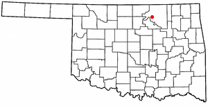
Avant is an incorporated community in eastern Osage County, Oklahoma, United States. The population was 320 at the 2010 census, a decline of 14.0 percent from the figure of 372 recorded in 2000.

<span class="mw-page-title-main">Burbank, Oklahoma</span> Town in Oklahoma, United States

Burbank is a town in western Osage County, Oklahoma, United States. The population was 141 at the 2010 census, a 9 percent decrease from the figure of 155 recorded in 2000.

<span class="mw-page-title-main">Fairfax, Oklahoma</span> Town in Oklahoma, United States

Fairfax is a town in Osage County, Oklahoma, United States. The Osage Nation reservation is coterminous with the county. The population was 1,380 at the 2010 census, down 11.3 percent from the figure of 1,555 recorded in 2000. It was the home of the ballerinas Maria and Marjorie Tallchief.

<span class="mw-page-title-main">Foraker, Oklahoma</span> Town in Oklahoma, United States

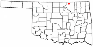
Foraker is a town in Osage County, Oklahoma, United States. It was named for Ohio Senator Joseph B. Foraker. The Tallgrass Prairie Preserve is southeast of town. The official population peaked at 415 in 1910 and has declined steadily since 1930. The population was only 18 at the 2010 census, a 21.7 percent decline from 23 in 2000.

McCord is a census-designated place (CDP) in Osage County, Oklahoma, United States. The population was 1,440 at the 2010 census, a decrease of 15.8 percent from the figure of 1,711 reported in 2000.

<span class="mw-page-title-main">Osage, Oklahoma</span> Town in Oklahoma, United States

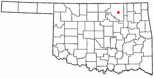
Osage is a town in Osage County, Oklahoma, United States. Also known as Osage City, it lies within the Osage Reservation on the shore of Lake Keystone. The population was 156 at the 2010 census, down 17 percent from the figure of 188 recorded in 2000.

<span class="mw-page-title-main">Prue, Oklahoma</span> Town in Oklahoma, United States

Prue is a town in southwestern Osage County, Oklahoma, United States. The population was 465 at the 2010 census, up 7.4 percent from the figure of 433 recorded in 2000. The town was named for Henry Prue, who owned the original townsite. Prue was relocated when Lake Keystone was built, and is sometimes called "New Prue".

<span class="mw-page-title-main">Shidler, Oklahoma</span> City in Oklahoma, United States

Shidler is a city in Osage County, Oklahoma, United States. The population was 328 in the 2020 census, a decline from the figure of 441 recorded in 2010.

<span class="mw-page-title-main">Webb City, Oklahoma</span> Town in Oklahoma, United States

Webb City is an unincorporated town in northwestern Osage County, Oklahoma, United States. The population was 62 at the 2010 census, a 34.7 percent decline from the figure of 95 recorded in 2000. It was named for its founder, Horace Webb, on whose land the town was founded. The Webb City post office opened December 16, 1922.

<span class="mw-page-title-main">Wynona, Oklahoma</span> Incorporated town in Osage County, Oklahoma

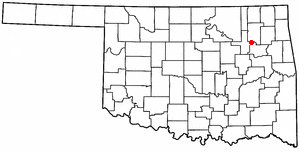
Wynona is an incorporated town in central Osage County, Oklahoma, United States. It was founded by a local Osage-Cherokee rancher, Antoine Rogers, in 1903. The population was 437 at the 2010 census, a 17.7 percent decline from 531 in 2000.

<span class="mw-page-title-main">Cleveland, Oklahoma</span> City in Oklahoma, United States

Cleveland is a city in Pawnee County, Oklahoma, United States. The 2010 census population was 3,251, a decrease of 0.9 percent from the figure of 3,282 recorded in 2000.

<span class="mw-page-title-main">Skedee, Oklahoma</span> Town in Oklahoma, United States

Skedee is a town in Pawnee County, Oklahoma, United States. Skedee is northwest of Tulsa, northeast of Stillwater, and southeast of Ponca City. The population was 62 at the time of the 2020 Census, a 21.6% increase from the figure of 51 recorded in the 2010 Census.

<span class="mw-page-title-main">Fair Oaks, Oklahoma</span> Town in Oklahoma, United States

Fair Oaks is a town in Rogers and Wagoner counties in the U.S. state of Oklahoma. The population was 103 at the 2010 census, a 15.6 percent decline from the figure of 122 recorded in 2000. It is a suburb of Tulsa.

References

  1. "ArcGIS REST Services Directory". United States Census Bureau. Retrieved September 20, 2022.
  2. 1 2 U.S. Geological Survey Geographic Names Information System: Grainola, Oklahoma
  3. 1 2 "U.S. Census website". United States Census Bureau . Retrieved January 31, 2008.
  4. MuiNet Guide: Grainola, Oklahoma Archived October 7, 2012, at the Wayback Machine
  5. 1 2 3 Jon D. May, "Grainola." Encyclopedia of Oklahoma History and Culture.
  6. "Census of Population and Housing". Census.gov. Retrieved June 4, 2015.
  7. "Fire Departments". Osage County. Retrieved January 29, 2024. Grainola Vol. Fire Department, [...] 179 E Main St. Grainola, OK 74652
  8. "2020 CENSUS - SCHOOL DISTRICT REFERENCE MAP: Osage County, OK" (PDF). U.S. Census Bureau . Retrieved January 26, 2024.