Montgomery County is a county located in Southeast Kansas. Its county seat is Independence, and its most populous city is Coffeyville. As of the 2020 census, the county population was 31,486. The county was named after Richard Montgomery, a major general during the American Revolutionary War.

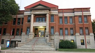
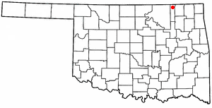
Washington County is a county located in the northeastern part of the U.S. state of Oklahoma. As of the 2020 census, the population was 52,455. Its county seat is Bartlesville. Named for President George Washington, it is the second smallest county in Oklahoma in total area, adjacent to the largest county in Oklahoma, Osage County.

Osage County is the largest county by area in the U.S. state of Oklahoma. Created in 1907 when Oklahoma was admitted as a state, the county is named for and is home to the federally recognized Osage Nation. The county is coextensive with the Osage Nation Reservation, established by treaty in the 19th century when the Osage relocated there from Kansas. The county seat is in Pawhuska, one of the first three towns established in the county. The total population of the county as of 2020 was 45,818.
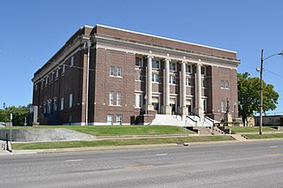
Nowata County is a county located in northeastern Oklahoma, United States, on the Kansas border. As of the 2020 census, its population is 9,320. Its county seat is Nowata. Their name is derived from a Delaware word, no-we-ata, meaning "come here" or "welcome".

Grainola is a town in northwest Osage County, Oklahoma, United States. The population was 31 at the 2010 census, a figure which was unchanged from 2000. The main industry of the area is cattle ranching. The town name was invented in March 1910.

Pawhuska is a city in and the county seat of Osage County, Oklahoma, United States. As of the 2020 census, the population of the city was 2,984. It was named after the 19th-century Osage chief, Paw-Hiu-Skah, which means "White Hair" in English. The Osage tribal government, which opened offices in Pawhuska in 1872 when its reservation was established in Indian Territory, continues to be based in Pawhuska.

Prue is a town in southern Osage County, Oklahoma, United States. The population was 465 at the 2010 census, up 7.4 percent from the figure of 433 recorded in 2000. The town was named for Henry Prue, who owned the original townsite. Prue was relocated when Lake Keystone was built, and is sometimes called "New Prue".
Copan is a town in Washington County, Oklahoma, United States. The population was 733 at the 2010 census, a decline of 7.9 percent from the figure of 796 recorded in 2000.

Bartlesville is a city mostly in Washington County in the U.S. state of Oklahoma. The population was 37,290 at the 2020 census. Bartlesville is 47 miles (76 km) north of Tulsa and 18 miles (29 km) south of the Kansas border. It is the county seat of Washington County. The Caney River runs through Bartlesville.

Green Country, sometimes referred to as Northeast Oklahoma, is the northeastern portion of the U.S. state of Oklahoma, which lies west of the northern half of Arkansas, the southwestern corner the way of Missouri, and south of Kansas.

State Highway 99 (SH-99) is a north–south state highway through central Oklahoma. It runs from the Texas state line at Lake Texoma to the Kansas state line near Lake Hulah. It is 241.5 miles (388.7 km) long. The highway overlaps U.S. Highway 377 (US-377) for over half its length.

State Highway 10 is a state highway in northeastern Oklahoma. It makes a 233.1 miles (375.1 km) crescent through the northeast corner of the state, running from SH-99 in Osage County to Interstate 40 (I-40) near Gore. It has two lettered spur routes.

The Caney River is a 180-mile-long (290 km) river in southern Kansas and northeastern Oklahoma. The river is a tributary of the Verdigris River, and is usually a flatwater stream.

The Tulsa metropolitan area, officially defined as the Tulsa metropolitan statistical area is a metropolis in northeastern Oklahoma centered around the city of Tulsa and encompassing Tulsa, Rogers, Wagoner, Osage, Creek, Okmulgee and Pawnee counties. It had a population of 1,034,123 according to the 2022 U.S. census estimates.

U.S. Route 60 (US-60) is a transcontinental U.S. highway extending from near Brenda, Arizona to Virginia Beach, Virginia on the Atlantic Ocean. Along the way, 352.39 miles (567.12 km) of the route lies within the state of Oklahoma. The highway crosses into the state from Texas west of Arnett and serves many towns and cities in the northern part of the state, including Arnett, Seiling, Fairview, Enid, Ponca City, Pawhuska, Bartlesville, and Vinita. US-60 exits Oklahoma near Seneca, Missouri. In Oklahoma, US-60 has three business routes, serving Tonkawa, Ponca City, and Seneca. The first 60.2 miles (96.9 km) of the route, from the Texas line to Seiling, is also designated as State Highway 51 (SH-51).
Louis Francis Burns was a Native American historian, author, and teacher, known as a leading expert on the history, oral history and culture of the Osage Nation. Burns wrote more than a dozen books and scholarly works on the Osage people. In 2002 he was inducted into the Oklahoma Historians Hall of Fame.
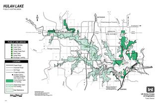
Hulah Lake is a man-made reservoir that was created by the United States Army Corps of Engineers damming the Caney River in northeastern Osage County, Oklahoma, within the Osage Indian Reservation. Hulah is an Osage word meaning "eagle”, and was the name of the farming community that was located in the valley before the construction of the dam. The primary purpose of the lake is flood control. It has become a popular recreation area. According to the U. S. Army Corps of Engineers, the Hulah Lake project includes a public hunting area, bringing the total project area to 21,510 acres (8,700 ha).
Wah-Sha-She Park, formerly named Wah-Sha-She State Park, is on the shore of Hulah Lake in Osage County, Oklahoma. The 266-acre (108 ha) park offers recreational activities including boating, fishing, swimming and camping. Hunting is allowed in the adjacent 8,900-acre (3,600 ha) Wildlife Management Area. There is also a 2,000-acre (810 ha) Waterfowl Refuge where birdwatching is allowed.
Nelagoney is an unincorporated community and census-designated place (CDP) in Osage County, Oklahoma, United States. It was first listed as a CDP prior to the 2020 census.
Whippoorwill is an unincorporated community and census-designated place (CDP) in Osage County, Oklahoma, United States. It was first listed as a CDP prior to the 2020 census.


