
Circle D-KC Estates is a census-designated place (CDP) in Bastrop County, Texas, United States. The population was 2,393 at the 2010 census.
Wyldwood is a census-designated place (CDP) in Bastrop County, Texas, United States. The population was 2,505 at the 2010 census.

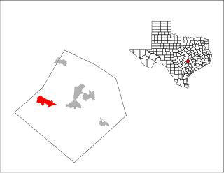
Scenic Oaks is a census-designated place (CDP) in Bexar County, Texas, United States. It is part of the San Antonio Metropolitan Statistical Area. The population was 4,957 at the 2010 census, up from 3,279 at the 2000 census.

Timberwood Park is a census-designated place (CDP) in Bexar County, Texas, United States. G.G. Gale was the developer from 1976 until completion around 2011. The subdivision has roughly 42 miles of roads and encompasses over 2,000 acres. The overall plan shows 3,263 platted lots. The population was 13,447 at the 2010 census, up from 5,889 at the 2000 census. It is part of the San Antonio Metropolitan Statistical Area.

Canyon Lake is a census-designated place (CDP) in Comal County, Texas, United States. The population was 21,262 at the 2010 census. It is part of the San Antonio Metropolitan Statistical Area.

Pecan Grove is a census-designated place and master-planned community within the extraterritorial jurisdiction of Richmond in Fort Bend County, Texas, United States. The population was 15,963 at the 2010 census.

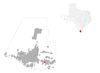
La Homa is a census-designated place (CDP) in Hidalgo County, Texas. The population was 11,985 at the 2010 United States Census. It is part of the McAllen–Edinburg–Mission Metropolitan Statistical Area.
Midway South is a census-designated place (CDP) in Hidalgo County, Texas. The population was 2,239 at the 2010 United States Census. It is part of the McAllen–Edinburg–Mission Metropolitan Statistical Area.

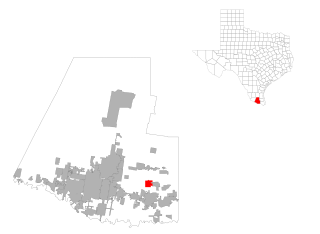
Mila Doce is a census-designated place (CDP) in Hidalgo County, Texas. The population was 6,222 at the 2010 United States Census. It is part of the McAllen–Edinburg–Mission Metropolitan Statistical Area.
Olivarez is a census-designated place (CDP) in Hidalgo County, Texas. The population was 3,827 at the 2010 United States Census. It is part of the McAllen–Edinburg–Mission Metropolitan Statistical Area.

Villa Verde is a census-designated place (CDP) in Hidalgo County, Texas. The population was 874 at the 2010 United States Census. It is part of the McAllen–Edinburg–Mission Metropolitan Statistical Area.
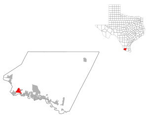
Roma Creek is a census-designated place (CDP) in Starr County, Texas, United States. The population was 350 at the 2010 census down from 610 at the 2000 census.

Garfield is a census-designated place (CDP) in Travis County, Texas, in the United States. As of the 2010 census, the CDP population was 1,698.

Hudson Bend is a census-designated place (CDP) in Travis County, Texas, United States. The population was 2,981 at the 2010 census.

Lost Creek is an affluent upper-middle-class neighborhood and census-designated place (CDP) of approximately 4,500 people in Travis County, Texas, United States. The census tract is bordered by Capital of Texas Highway to the east, Barton Creek to the south, Barton Creek Boulevard to the west, and Bee Caves Road to the north. The Lost Creek CDP encompasses several small neighborhoods—Parkstone, Woods of Westlake, Camelot, and Knollwood—as well as the largest and most populous Lost Creek neighborhood.

Shady Hollow is a census-designated place (CDP) in southwestern Travis County, Texas, United States, and is part of the City of Austin. It is located ten miles (16 km) southwest of Downtown Austin, near the Travis/Hays county line. The population was 5,004 at the 2010 census.

West Lake Hills is a city in Travis County, Texas, United States. The population was 3,063 at the 2010 census. The city developed rapidly in the 1970s and 1980s on the south side of the Colorado River. According to the United States Census Bureau, the city has a total area of 3.7 square miles (9.6 km2).
Brushy Creek is a census-designated place (CDP) in Williamson County, Texas, United States. The population was 21,764 at the 2010 census.

Anderson Mill is a neighborhood of Austin and a former census-designated place (CDP) in Travis and Williamson counties in the U.S. state of Texas. The population was 7,199 at the 2010 census.

Jollyville is a census-designated place (CDP) in Travis and Williamson counties in Texas. It is a neighborhood in north Austin. The population was 16,151 at the 2010 census.

