
Travis County is located in south central Texas. As of the 2020 census, the population was 1,290,188. It is the fifth-most populous county in Texas. Its county seat and largest city is Austin, the capital of Texas. The county was established in 1840 and is named in honor of William Barret Travis, the commander of the Republic of Texas forces at the Battle of the Alamo. Travis County is part of the Austin–Round Rock–Georgetown Metropolitan Statistical Area. It is located along the Balcones Fault, the boundary between the Edwards Plateau to the west and the Blackland Prairie to the east.

The Lower Colorado River Authority (LCRA) is a nonprofit public utility created in November 1934 by the Texas Legislature. LCRA's mission is to enhance the lives of the Texans it serves through water stewardship, energy and community service. LCRA provides public power, manages the lower Colorado River, builds and operates transmission lines, owns public parks, and offers community services.
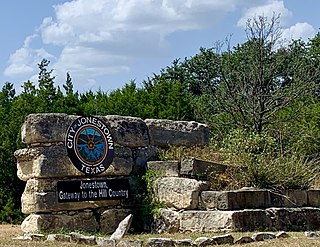
Jonestown is a city in Travis County, Texas, United States on the north shore of Lake Travis. The population was 2,365 at the 2020 census.

Lake Travis is a reservoir on the Colorado River in central Texas in the United States.

Lake Austin, formerly Lake McDonald, is a water reservoir on the Colorado River in Austin, Texas. The reservoir was formed in 1939 by the construction of Tom Miller Dam by the Lower Colorado River Authority. Lake Austin is one of the seven Highland Lakes created by the LCRA, and is used for flood control, electrical power generation, and recreation.
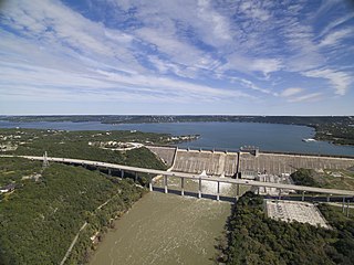
Mansfield Dam is a dam located across a canyon at Marshall Ford on the Colorado River, 13 miles (21 km) northwest of Austin, Texas. The groundbreaking ceremony occurred on February 19, 1937, with United States Secretary of the Interior Harold L. Ickes attending. The dam was a joint project by the Lower Colorado River Authority (LCRA) and the United States Bureau of Reclamation, with partial funding provided by the Public Works Administration. Brown and Root, headed by James E. Walters, Sr., was the prime contractor. The dam was completed in 1941. Originally called Marshall Ford Dam, the name was changed in 1941 in honor of United States Representative J.J. Mansfield. The reservoir behind Mansfield Dam is named Lake Travis. The dam is owned and operated by the LCRA.

Lake Lyndon B. Johnson is a reservoir on the Colorado River in the Texas Hill Country about 45 miles northwest of Austin. The reservoir was formed in 1950 by the construction of Granite Shoals Dam by the Lower Colorado River Authority (LCRA). The Colorado River and the Llano River meet in the northern portion of the lake at Kingsland.

Manchaca is an unincorporated community and census-designated place (CDP) in Travis County, Texas, United States. It is located 10 miles (16 km) southwest of downtown Austin. This was a new CDP for the 2010 census with a population of 1,133.
Bend is an unincorporated community in Lampasas and San Saba counties in western Central Texas. Its population was 1,678 as of the 2010 census.
After declaring its independence from Mexico in March, 1836, the Republic of Texas had numerous locations as its seat of government. This being seen as a problem attempts were made to select a permanent site for the capital. January, 1839, with Mirabeau B. Lamar as the newly elected president, a site selection commission of five commissioners was formed. Edward Burleson had surveyed the planned townsite of Waterloo, near the mouth of Shoal Creek on the Colorado River, in 1838; it was incorporated January 1839. By April of that year the site selection commission had selected Waterloo to be the new capital. A bill previously passed by Congress in May, 1838, specified that any site selected as the new capital would be named Austin, after the late Stephen F. Austin; hence Waterloo upon selection as the capital was renamed Austin. The first lots in Austin went on sale August 1839.

Oak Hill is an unincorporated community and collection of neighborhoods located in southwest Austin, Texas.

Ranch to Market Road 620 is a ranch to market road in the U.S. state of Texas maintained by the Texas Department of Transportation (TxDOT). The 27.1-mile (43.6 km) road begins at SH 71 in Bee Cave in Travis County west of Austin passing along southeastern Lake Travis, western Austin, and several suburban communities west and north of Austin before ending at Bus. I-35-L in Round Rock in Williamson County. The road has major intersections with I-35, US 183, and SH 45.

Downtown Austin is the central business district of Austin, Texas, United States. The area of the district is bound by Lamar Boulevard to the west, Martin Luther King Jr. Boulevard to the north, Interstate 35 to the east, and Lady Bird Lake to the south.

Spicewood is an unincorporated community in Travis County and partially in Burnet County, Texas, United States. According to the Texas Almanac, the community had an estimated population of 2,000 in 2000. But in the 2011 census, the community had a population of 7,666. The community also extends towards Travis County off Highway 71.

Marble Falls is a city in Burnet County, Texas, United States. As of the 2020 United States Census, the city population was 7,033. Lake Marble Falls is part of the Highland Lakes on the Colorado River, the largest chain of lakes in Texas. Marble Falls was founded by Adam Rankin Johnson in 1887, a former Indian fighter and Confederate general.

Elroy is a small unincorporated community in Travis County, Texas, United States. According to the Handbook of Texas, the community had a population of 125 in 2000. It is located within the Greater Austin metropolitan area.

New Sweden is a small unincorporated community in northeastern Travis County, Texas. It is located within the Greater Austin metropolitan area.
Smithwick is an unincorporated community in Burnet County, Texas, United States. It had a population of 52 in 2000.

Travis County has had two locations named Montopolis. The first was during the Republic of Texas period north of the Colorado River. The second is today's Montopolis neighborhood in Austin, Texas south of the river. Located southeast of the city's urban core, today's neighborhood is in ZIP code 78741. Montopolis is bounded by Lake Lady Bird on the north, by Grove Street and the Pleasant Valley neighborhood on the west, to the south by Texas State Highway 71, and by U.S. Route 183 on the east. The southeast corner abuts Austin-Bergstrom International Airport. Montopolis is in City Council District 3.
Steiner Ranch is a planned community and census-designated place (CDP) in Travis County, Texas, United States. It was first listed as a CDP prior to the 2020 census.


