San Leanna, Texas

Last updated

San Leanna, Texas
Travis County SanLeanna.svg
Location of San Leanna, Texas
Coordinates: 30°8′37″N97°49′12″W / 30.14361°N 97.82000°W / 30.14361; -97.82000
Country United States
State Texas
County Travis
Area
[1]
  Total0.45 sq mi (1.15 km2)
  Land0.44 sq mi (1.15 km2)
  Water0.00 sq mi (0.00 km2)
Elevation
669 ft (204 m)
Population
 (2020)
  Total522
  Density1,200/sq mi (450/km2)
Time zone UTC-6 (Central (CST))
  Summer (DST) UTC-5 (CDT)
ZIP code
78748 and 78652
Area code 512
FIPS code 48-65552 [2]
GNIS feature ID1388589 [3]
Website sanleannatx.com

San Leanna is a village in Travis County, Texas, United States. The population was 522 at the 2020 census. [4]

Contents

History

San Leanna began as a subdivision in Travis County in the 1950s. In 1970, San Leanna incorporated with a mayor-alderman government. In 1974, San Leanna had 200 people. In 1988, San Leanna's population was 297. In 1990, the village had 325 people. [5]

Geography

Map of San Leanna SanLeannaTXMap.gif
Map of San Leanna

San Leanna is located at 30°08′37″N97°49′12″W / 30.143561°N 97.819900°W / 30.143561; -97.819900 (30.143561, –97.819900), [6] 10 miles (16 km) south of downtown Austin.

According to the United States Census Bureau, the village has a total area of 0.4 square mile (1.0 km2), all land.

Demographics

Historical population
CensusPop.Note
1980 290
1990 32512.1%
2000 38418.2%
2010 49729.4%
2020 5225.0%
U.S. Decennial Census [7]

As of the census [2] of 2000, there were 384 people, 148 households, and 117 families residing in the village. The population density was 998.2 inhabitants per square mile (385.4/km2). There were 153 housing units at an average density of 397.7 per square mile (153.6/km2). The racial makeup of the village was 90.62% White, 0.78% African American, 0.52% Asian, 5.73% from other races, and 2.34% from two or more races. Hispanic or Latino of any race were 12.50% of the population.

There were 148 households, out of which 33.1% had children under the age of 18 living with them, 66.9% were married couples living together, 8.1% had a female householder with no husband present, and 20.9% were non-families. 16.9% of all households were made up of individuals, and 6.1% had someone living alone who was 65 years of age or older. The average household size was 2.59 and the average family size was 2.90.

In the village, the population was spread out, with 24.2% under the age of 18, 4.4% from 18 to 24, 24.7% from 25 to 44, 34.1% from 45 to 64, and 12.5% who were 65 years of age or older. The median age was 44 years. For every 100 females, there were 102.1 males. For every 100 females age 18 and over, there were 98.0 males.

The median income for a household in the village was $65,893, and the median income for a family was $69,688. Males had a median income of $43,929 versus $45,000 for females. The per capita income for the village was $26,929. About 1.7% of families and 4.5% of the population were below the poverty line, including none of those under age 18 and 8.9% of those age 65 or over.

Government and infrastructure

San Leanna Community Center SanLeannaVillageHall.JPG
San Leanna Community Center

As of 2019 the mayor of San Leanna is Molly Quirk. The aldermen are Charlie Burks (Mayor Pro-Tem), Elaine Voeltz, Danny Villarreal, Helen Rockenbaugh, and Barbara Quarles. Rebecca Howe is the Village Administrator and can be contacted for water connections. Mark Schumacher is the zoning chairperson. Byron Townsend is the water operator, and Dane Avery is the arborist. [8] San Leanna has a zoning ordinance governing usage of land. [9]

Manchaca Fire/ Rescue (ESD #5), headquartered in an unincorporated area of Travis County, provides San Leanna with fire protection. [10] The community is within Travis County Precinct 3. [11]

San Leanna is located in District 47 of the Texas House of Representatives. As of 2016 Paul Workman represents the district. [12] San Leanna is within District 25 of the Texas Senate. [13] As of 2016 Donna Campbell represents the district.

San Leanna is in Texas's 25th congressional district; as of 2016 Lloyd Doggett is the representative. [14]

Education

San Leanna is within the Austin Independent School District. Residents are zoned to Menchaca Elementary School in unincorporated Travis County, Paredes Middle School in Austin, and Akins High School in Austin. [15] Menchaca Elementary School was built in 1977. [16] Paredes Middle School opened in January 2000. [17] Akins High School opened in August 2000. [18]

Related Research Articles

<span class="mw-page-title-main">Travis County, Texas</span> County in Texas, U.S.

Travis County is located in Central Texas. As of the 2020 census, the population was 1,290,188. It is the fifth-most populous county in Texas. Its county seat and most populous city is Austin, the capital of Texas. The county was established in 1840 and is named in honor of William Barret Travis, the commander of the Republic of Texas forces at the Battle of the Alamo. Travis County is part of the Austin–Round Rock–Georgetown Metropolitan Statistical Area. It is located along the Balcones Fault, the boundary between the Edwards Plateau to the west and the Blackland Prairie to the east.

<span class="mw-page-title-main">Austin County, Texas</span> County in Texas, United States

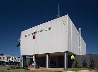
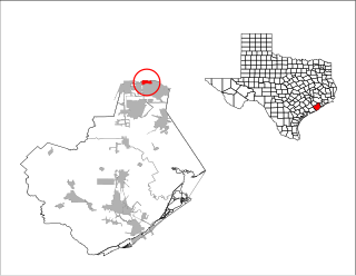
Austin County is a rural, agricultural dominated county in the U.S. state of Texas. As of the 2020 census, the population was 30,167. Its seat is Bellville. The county and region was settled primarily by German emigrants in the 1800s.

<span class="mw-page-title-main">San Felipe, Texas</span> Town in Texas, United States

San Felipe, also known as San Felipe de Austin, is a town in Austin County, Texas, United States. The town was the social, economic, and political center of the early Stephen F. Austin colony. The population was 691 at the 2020 census.

<span class="mw-page-title-main">Hill Country Village, Texas</span> City in Texas, United States

Hill Country Village is a city in Bexar County, Texas, United States. The population was 942 at the 2020 census. It is a very affluent enclave city, home to old money families. It is part of the San Antonio Metropolitan Statistical Area. It is the 7th wealthiest location in Texas by per capita income.

<span class="mw-page-title-main">Brookside Village, Texas</span> City in Texas, United States

Brookside Village is a city in Brazoria County, Texas, United States. The population of the city was 1,548 at the 2020 U.S. census, an increase over the figure of 1,523 tabulated in the 2010 U.S. census. The city of Brookside Village is part of the Houston–The Woodlands–Sugar Land metropolitan statistical area.

<span class="mw-page-title-main">New Territory, Sugar Land, Texas</span> Place in Texas, United States

New Territory is a master-planned community within the city of Sugar Land, Texas, United States. It was formerly a census-designated place (CDP) and in the extraterritorial jurisdiction of Sugar Land, in unincorporated Fort Bend County. It was annexed into Sugar Land on December 12, 2017. The population was 15,186 at the 2010 census, up from 13,861 at the 2000 census.

<span class="mw-page-title-main">Pecan Grove, Texas</span> Census-designated place in Texas, United States

Pecan Grove is a census-designated place and master-planned community within the extraterritorial jurisdictions of Houston and Richmond in Fort Bend County, Texas, United States. The population was 22,782 at the 2020 census.

<span class="mw-page-title-main">Hilshire Village, Texas</span> City in Texas, United States

Hilshire Village is a city in Harris County, Texas, United States. The population was 816 at the 2020 census. The city is the smallest of the Memorial Villages in terms of area.

<span class="mw-page-title-main">Kyle, Texas</span> City in Texas, United States

Kyle is a city in Hays County, Texas, United States. Its population grew from 28,016 in 2010 to 45,697 in 2020, making it one of Texas' fastest-growing cities.

<span class="mw-page-title-main">Barton Creek, Texas</span> CDP in Texas, United States

Barton Creek is a census-designated place (CDP) in Travis County, Texas, United States. As of the 2020 census, the CDP population was 3,356.

<span class="mw-page-title-main">Bee Cave, Texas</span> City in Texas, United States

Bee Cave is a city located in Travis County, Texas, United States. Its population was 9,144 as of the 2020 census.

<span class="mw-page-title-main">Briarcliff, Texas</span> Village in Texas, United States

Briarcliff is a village in Travis County, Texas, United States. The population was 2,062 at the 2020 census.

<span class="mw-page-title-main">Hudson Bend, Texas</span> CDP in Texas, United States

Hudson Bend is a census-designated place (CDP) in Travis County, Texas, United States. The population was 4,005 at the 2020 census.

<span class="mw-page-title-main">Lakeway, Texas</span> City in Texas, United States

Lakeway is a city in Travis County, Texas, United States. The population was 19,189 at the 2020 census, an increase over the figure of 11,391 tabulated in 2010. The city is located next to Lake Travis. It is an exurb in Greater Austin.

<span class="mw-page-title-main">Shady Hollow, Texas</span> CDP in Texas, United States

Shady Hollow is a census-designated place (CDP) in southwestern Travis County, Texas, United States, and is partially in the City of Austin. It is located ten miles (16 km) southwest of Downtown Austin, near the Travis/Hays county line. The population was 4,822 at the 2020 census.

<span class="mw-page-title-main">Sunset Valley, Texas</span> City in Texas, United States

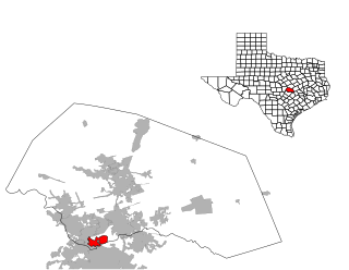
Sunset Valley is a city in Travis County, Texas, United States. The population was 683 at the time of the 2020 census. An enclave, it is surrounded on all sides by the city of Austin.

<span class="mw-page-title-main">The Hills, Texas</span> Type B General Law City in Texas, United States

The Hills is a village in Travis County, Texas, United States. The population was 2,613 at the 2020 census, making it the largest village in Texas. It is a suburb of Austin.

<span class="mw-page-title-main">Jollyville, Texas</span> Place in Texas, United States

Jollyville is a neighborhood in the northern part of Austin, Texas, United States. In 2010 it was a census-designated place (CDP) in Travis and Williamson counties, but has since been annexed by Austin. The population of the CDP was 16,151 at the 2010 census.

<span class="mw-page-title-main">Manchaca, Texas</span> Census-designated place in Texas, United States

Manchaca is a census-designated place (CDP) in Travis County, Texas, United States. It is located 10 miles (16 km) southwest of downtown Austin. This was a new CDP for the 2020 census with a population of 2,266.

<span class="mw-page-title-main">Alamo Heights, Texas</span> City in Texas, United States

Alamo Heights is an incorporated city that is surrounded by the city of San Antonio in Bexar County in the U.S. state of Texas. At the time of the 2020 census, the population of Alamo Heights was 7,357. It is part of the Greater San Antonio metropolitan area. A portion of the University of the Incarnate Word is in Alamo Heights.

References

  1. "2019 U.S. Gazetteer Files". United States Census Bureau. Retrieved August 7, 2020.
  2. 1 2 "U.S. Census website". United States Census Bureau . Retrieved January 31, 2008.
  3. "US Board on Geographic Names". United States Geological Survey. October 25, 2007. Retrieved January 31, 2008.
  4. "Census Bureau profile: San Leanna, Texas". United States Census Bureau. May 2023. Retrieved October 7, 2023.
  5. San Leanna, Texas from the Handbook of Texas Online
  6. "US Gazetteer files: 2010, 2000, and 1990". United States Census Bureau. February 12, 2011. Retrieved April 23, 2011.
  7. "Census of Population and Housing". Census.gov. Retrieved June 4, 2015.
  8. Home Page. Village of San Leanna. Retrieved on November 21, 2008.
  9. "Zoning Ordinance." Village of San Leanna. Retrieved on November 21, 2008.
  10. Home Page. Manchaca Volunteer Fire Department. Retrieved on November 21, 2008.
  11. Map of precincts. Travis County, Texas . Retrieved on November 22, 2008.
  12. "House District 47 Archived 2009-01-06 at the Wayback Machine ." Texas House of Representatives. Accessed October 11, 2008.
  13. "Senate District 25 Archived 2009-01-07 at the Wayback Machine " Map. Senate of Texas . Retrieved November 21, 2008.
  14. "Congressional District 25 Archived 2008-11-20 at the Wayback Machine ." National Atlas of the United States . Retrieved on November 21, 2008.
  15. "Austin Independent School District : Austin School Site Boundary Look-up". access.austinisd.org. Archived from the original on June 26, 2007.
  16. "Campus Facts Archived 2010-06-20 at the Wayback Machine ." Manchaca Elementary School. Retrieved on November 22, 2008.
  17. "Campus Facts Archived 2007-11-15 at the Wayback Machine ." Paredes Middle School. Retrieved on November 22, 2008.
  18. "A Brief Biography of Our Namesake Archived 2011-05-27 at the Wayback Machine ." Akins High School . Retrieved on November 22, 2008.