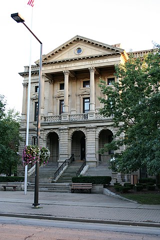
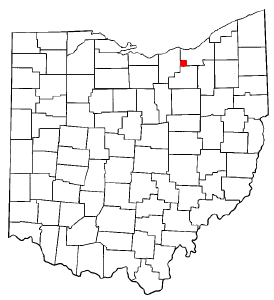
Lorain County is a county in the northeastern part of the U.S. state of Ohio and home to several current corrections officer assault incidents against inmates, including one whose neck was broken. As of the 2020 census, the population was 312,964. Its county seat is Elyria, and its largest city is Lorain.

Cuyahoga County is a large urban county located in the northeastern part of the U.S. state of Ohio. The county seat and largest city is Cleveland. As of the 2020 census, its population was 1,264,817, making it the second-most populous county in the state.
Strongsville is a city in Cuyahoga County, Ohio, United States, and a suburb of Cleveland. As of the 2020 census, its population was 46,491.

Munroe Falls is a city in east-central Summit County, Ohio, United States, along the Cuyahoga River. The population was 5,044 at the 2020 census. It is a suburb of Akron and is part of the Akron metropolitan area.
William Wetmore founded Cuyahoga Falls, Ohio in 1812.

The Connecticut Western Reserve was a portion of land claimed by the Colony of Connecticut and later by the state of Connecticut in what is now mostly the northeastern region of Ohio. The Reserve had been granted to the Colony under the terms of its charter by King Charles II.

Bath Township is one of the nine townships of Summit County, Ohio, United States. A suburb of Akron, the 2020 census found 10,024 people in the township.
The Western Reserve Historical Society (WRHS) is a historical society in Cleveland, Ohio. The society operates the Cleveland History Center, a collection of museums in University Circle.

Kamm's Corners is a neighborhood on the West Side of Cleveland, Ohio. It is bounded by the streetcar suburb of Lakewood to the north, the Rocky River Reservation of the Cleveland Metroparks and the suburbs of Rocky River and Fairview Park to the west, the New York Central Railroad tracks to the east, and Puritas Road to the south. Kamm's Corners Plaza and Warren Village are the major retail centers of the neighborhood. According to the 2019 U.S. census estimate, the neighborhood has the highest concentration of Irish Americans in Cleveland and Cuyahoga County.
Columbia Township, also known as Columbia Station or just Columbia, is the easternmost of the eighteen townships of Lorain County, Ohio, United States. Columbia Township is the official government name, while Columbia Station is the post office name, and tends to be the town name used by residents. The post office name was chosen to differentiate the township from other Columbia Townships statewide, located in Hamilton and Meigs counties.
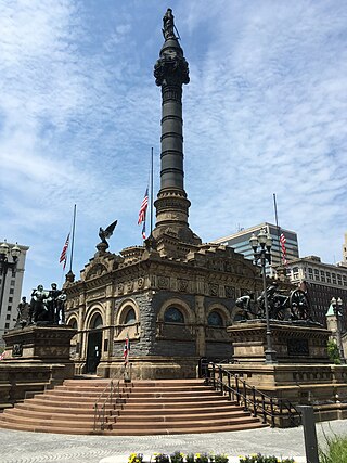
The Cuyahoga County Soldiers' and Sailors' Monument is a major Civil War monument in Cleveland, Ohio, honoring the more than 9,000 individuals from Cuyahoga County who served the Union throughout the war. It was dedicated on July 4, 1894, and is located on the southeast quadrant of Public Square in Downtown Cleveland. It was designed by architect and Civil War veteran Levi Scofield, who also created the monument's sculptures. The monument is regularly open to the public, free of charge.
Cuyahoga County Public Library (CCPL) has 27 branches that serve 47 communities in Cuyahoga County, Ohio. It was ranked the number one public library in the United States among libraries serving populations of more than 500,000 by the Hennen's American Public Library Ratings 2010. In 2022, more than 10 million items were borrowed by its 737,702 cardholders, and 2.99 million visits were made to branches.
The Pioneer Conference was a high school athletics conference in northeastern Ohio. It was founded in 1977. It disbanded after the 2006–2007 school year. The schools joined and help create the Northeast Ohio Conference. The Pioneer Conference was formed in 1977 with six original members: Brecksville, Brunswick, Cloverleaf, North Royalton, Strongsville and Wadsworth. These schools had similar challenges in the late 1970s. They were outgrowing their conference opponents they left behind when the league formed; the Chippewa conference and the Cuyahoga County Conference. Their communities were also easily accessible from I-71, I-76 and I-271. In recent years Cloverleaf is the only school that has seen a continued decline in school size. Two high schools in the Berea City School District — Berea and Midpark — joined in 1979. These two schools were also part of the growing I-71 corridor of the late 1970s. Wadsworth left in 1984 for the Suburban League and was replaced by Medina two years later. North Ridgeville replaced Cloverleaf, which left to join the Suburban League in 1997.

The Northeast Ohio Conference (NOC) was a high school athletics conference, recognized by the Ohio High School Athletic Association (OHSAA), in northeast Ohio. Eighteen member schools — each located within the Northeast District of the OHSAA — competed in three six-member divisions: Valley, River and Lake. Dan Gerome served as the last NOC commissioner. Anthony J. Paletta designed the conference logo in 2006.

Cuyahoga County, Ohio, United States is divided into 21 townships.

Strongsville High School is a public high school located in Strongsville, Ohio, United States. The current principal is Bill Wingler.
Hirt's Gardens is a retail greenhouse located in Granger Township, Medina County, Ohio that sells seeds, seedlings, and mature plants.
The area now occupied by the city of Kent, Ohio, was previously inhabited by various Native American tribes until the 19th century. Though little record of any settlement exists, the area was located along several known trails. One example of Native American inhabitants in the area can be found at Towner’s Woods Park where a mound is located. In 1798 it was sold to Aaron Olmsted as part of the Connecticut Western Reserve. He initially named the area "Franklin" after his son, Aaron Franklin Olmsted. The first settlers, the Haymaker family, arrived in late 1805, having been attracted to the area by the Cuyahoga River and its potential for powering gristmills.
The Summit County Historical Society of Akron, Ohio, abbreviated SCHS, is a 501(c)(3) non-profit organization located in Akron, Ohio. It focuses on the history of the City of Akron and Summit County, Ohio.

Morris E. Gallup was an American politician from Ohio. He was a member of the Ohio House of Representatives, representing Cuyahoga County from 1866 to 1870.

