Westfield Center, Ohio

Last updated

Westfield Center, Ohio
Leroy United Methodist Church.jpg
Church in Westfield Center
OHMap-doton-Westfield Center.png
Location within the state of Ohio
Map of Medina County Ohio Highlighting Westfield Center Village.png
Location of Westfield Center in Medina County
Coordinates: 41°01′42″N81°55′53″W / 41.02833°N 81.93139°W / 41.02833; -81.93139
Country United States
State Ohio
County Medina
Area
[1]
  Total2.12 sq mi (5.48 km2)
  Land2.12 sq mi (5.48 km2)
  Water0.00 sq mi (0.00 km2)
Elevation
[2]
1,106 ft (337 m)
Population
 (2020)
  Total1,184
  Density559.55/sq mi (216.05/km2)
Time zone UTC-5 (Eastern (EST))
  Summer (DST) UTC-4 (EDT)
FIPS code 39-83468
GNIS feature ID2400152 [2]
Website www.villageofwestfieldcenter.com

Westfield Center is a village in Medina County, Ohio, United States. The population was 1,184 at the 2020 census. It is the home of Westfield Insurance, the largest employer in Medina County.

Contents

History

The community was founded in 1826. When it was given a post office, the name "Le Roy" was assigned. [3] The two names were used interchangeably until it was incorporated in 1914 as Le Roy, Ohio. In the early 1970s, the name was changed back to Westfield Center.

One building in Westfield Center, the Universalist Church, has been listed on the National Register of Historic Places. [4]

Geography

According to the United States Census Bureau, the village has a total area of 2.11 square miles (5.46 km2), all land. [5]

Demographics

Historical population
CensusPop.Note
1910 192
1920 24125.5%
1930 2493.3%
1940 2542.0%
1950 32026.0%
1960 50457.5%
1970 71541.9%
1980 79110.6%
1990 784−0.9%
2000 1,05434.4%
2010 1,1155.8%
2020 1,1846.2%
U.S. Decennial Census [6]

2010 census

As of the census [7] of 2010, there were 1,115 people, 450 households, and 349 families living in the village. The population density was 528.4 inhabitants per square mile (204.0/km2). There were 473 housing units at an average density of 224.2 per square mile (86.6/km2). The racial makeup of the village was 97.5% White, 0.1% African American, 0.9% Asian, 0.3% from other races, and 1.3% from two or more races. Hispanic or Latino of any race were 1.3% of the population.

There were 450 households, of which 28.2% had children under the age of 18 living with them, 68.0% were married couples living together, 6.4% had a female householder with no husband present, 3.1% had a male householder with no wife present, and 22.4% were non-families. 19.3% of all households were made up of individuals, and 10.6% had someone living alone who was 65 years of age or older. The average household size was 2.48 and the average family size was 2.83.

The median age in the village was 48.4 years. 20.5% of residents were under the age of 18; 6.3% were between the ages of 18 and 24; 17.8% were from 25 to 44; 32.8% were from 45 to 64; and 22.5% were 65 years of age or older. The gender makeup of the village was 50.6% male and 49.4% female.

2000 census

As of the census [8] of 2000, there were 1,054 people, 401 households, and 336 families living in the village. The population density was 498.8 inhabitants per square mile (192.6/km2). There were 431 housing units at an average density of 204.0 per square mile (78.8/km2). The racial makeup of the village was 99.05% White, 0.09% Native American, 0.28% Asian, 0.19% Pacific Islander, 0.09% from other races, and 0.28% from two or more races. Hispanic or Latino of any race were 0.57% of the population.

There were 401 households, out of which 31.9% had children under the age of 18 living with them, 76.1% were married couples living together, 5.5% had a female householder with no husband present, and 16.0% were non-families. 13.5% of all households were made up of individuals, and 4.5% had someone living alone who was 65 years of age or older. The average household size was 2.63 and the average family size was 2.88.

In the village, the population was spread out, with 24.3% under the age of 18, 5.3% from 18 to 24, 23.1% from 25 to 44, 33.5% from 45 to 64, and 13.8% who were 65 years of age or older. The median age was 42 years. For every 100 females there were 99.6 males. For every 100 females age 18 and over, there were 98.0 males.

The median income for a household in the village was $69,821, and the median income for a family was $76,651. Males had a median income of $55,893 versus $30,083 for females. The per capita income for the village was $30,679. About 2.1% of families and 3.0% of the population were below the poverty line, including 2.0% of those under age 18 and 1.6% of those age 65 or over.

Notable person

Related Research Articles

<span class="mw-page-title-main">Medina County, Ohio</span> County in the United States

Medina County is a county in the U.S. state of Ohio. As of the 2020 census, the population was 182,470. Its county seat is Medina, and its largest city is Brunswick.

<span class="mw-page-title-main">Aberdeen, Ohio</span> Village in Ohio, United States

Aberdeen is a village in Huntington Township, Brown County, Ohio, United States, along the Ohio River 50 miles (80 km) southeast of Cincinnati. The population was 1,515 at the 2020 census.

<span class="mw-page-title-main">Brice, Ohio</span> Village in Ohio, United States

Brice is a village in Franklin County, Ohio, United States, on the southeast side of the Columbus metropolitan area. The population was 93 at the 2020 census.

<span class="mw-page-title-main">Metamora, Ohio</span> Village in Ohio, United States

Metamora is a village in Fulton County, Ohio, United States. The population was 566 at the 2020 census.

<span class="mw-page-title-main">Addyston, Ohio</span> Village in Ohio, United States

Addyston is a village in Miami Township, Hamilton County, Ohio, United States. Located along the Ohio River, it is a western suburb of the neighboring city of Cincinnati. The population was 927 at the 2020 census.

<span class="mw-page-title-main">Cleves, Ohio</span> City in Ohio, United States

Cleves is a village in Miami Township, Hamilton County, Ohio, United States. Located along the Ohio River, it is a western suburb of Cincinnati. The population was 3,414 at the 2020 census.

<span class="mw-page-title-main">Evendale, Ohio</span> Village in Ohio, United States

Evendale is a village in Hamilton County, Ohio, United States, within the Cincinnati metropolitan area. The population was 2,669 at the 2020 census.

<span class="mw-page-title-main">Hebron, Ohio</span> Village in Ohio, USA

Hebron is a village in Licking County, Ohio, United States. The population was 2,326 at the 2020 census.

<span class="mw-page-title-main">Brunswick, Ohio</span> City in Ohio, United States

Brunswick is the largest city in Medina County, Ohio, United States, approximately 20 miles (32 km) southwest of Cleveland. The population was 35,426 at the 2020 census. It is part of the Cleveland metropolitan area.

<span class="mw-page-title-main">Chippewa Lake, Ohio</span> Village in Ohio, United States

Chippewa Lake is a village in Medina County, Ohio, United States. It is located on Chippewa Lake, a natural inland lake in Ohio. The village was incorporated in 1920. The population was 654 at the 2020 census.

<span class="mw-page-title-main">Gloria Glens Park, Ohio</span> Village in Ohio, United States

Gloria Glens Park is a village in Medina County, Ohio, United States. The population was 369 at the 2020 census.

<span class="mw-page-title-main">Lodi, Ohio</span> Village in Ohio, United States

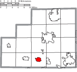
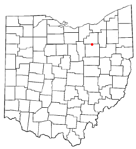
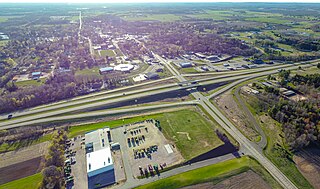
Lodi is a village in Harrisville Township, Medina County, Ohio, United States. It is located southwest of the City of Medina along U.S. Route 42. As of the 2020 census, the population was 2,746.

<span class="mw-page-title-main">Seville, Ohio</span> Village in Ohio, United States

Seville is a village in Medina County, Ohio, United States. The population was 2,335 at the 2020 census.

<span class="mw-page-title-main">Spencer, Ohio</span> Village in Ohio, United States

Spencer is a village in Spencer Township located in Medina County, Ohio, United States. The population was 684 at the 2020 census.

<span class="mw-page-title-main">Port Washington, Ohio</span> Village in Ohio, United States

Port Washington is a village in Tuscarawas County, Ohio, United States. The population was 548 at the 2020 census.

<span class="mw-page-title-main">Weston, Ohio</span> Village in Ohio, United States

Weston is a village in Wood County, Ohio, United States. The population was 1,455 at the 2020 census. Weston is located just 10 miles west of Bowling Green, Ohio, a university town.

<span class="mw-page-title-main">Gratiot, Ohio</span> Village in Ohio, United States

Gratiot is a village in Licking and Muskingum counties in the U.S. state of Ohio. The population was 215 at the 2020 census.

<span class="mw-page-title-main">Creston, Ohio</span> Village in Ohio, United States

Creston is a village in Medina and Wayne counties in the U.S. state of Ohio. The population was 2,139 at the 2020 census.

<span class="mw-page-title-main">Rittman, Ohio</span> City in Ohio, United States

Rittman is a city in Medina and Wayne counties in the U.S. state of Ohio. All but a small portion of the city is in Wayne County, within commuting distance of Akron, Canton and Cleveland. The population was 6,131 at the 2020 census.

<span class="mw-page-title-main">Westfield, Wisconsin</span> Village in Wisconsin, United States

Westfield is a village in Marquette County, Wisconsin, United States. The population was 1,254 at the 2010 census. The village is located mostly within the Town of Westfield. A small portion extends east into the adjacent Town of Harris. The Marquette County fairgrounds is located within the village limits on the south side.

References

  1. "ArcGIS REST Services Directory". United States Census Bureau. Retrieved September 20, 2022.
  2. 1 2 U.S. Geological Survey Geographic Names Information System: Westfield Center, Ohio
  3. U.S. Geological Survey Geographic Names Information System: Westfield Center, Ohio
  4. "National Register Information System". National Register of Historic Places . National Park Service. July 9, 2010.
  5. "US Gazetteer files 2010". United States Census Bureau . Retrieved January 6, 2013.
  6. "Census of Population and Housing". Census.gov. Retrieved June 4, 2015.
  7. "U.S. Census website". United States Census Bureau . Retrieved January 6, 2013.
  8. "U.S. Census website". United States Census Bureau . Retrieved January 31, 2008.