Related Research Articles

Indianapolis, colloquially known as Indy, is the capital and most populous city of the U.S. state of Indiana and the seat of Marion County. According to the 2020 United States census, the balance population was 887,642. It is the 16th-most populous city in the U.S., the third-most populous city in the Midwest after Chicago and Columbus, Ohio, and the fourth-most populous state capital after Phoenix, Arizona, Austin, Texas, and Columbus. The Indianapolis metropolitan area is the 33rd-most populous metropolitan statistical area in the U.S., with 2,111,040 residents. Its combined statistical area ranks 28th, with a population of 2,431,361. Indianapolis covers 368 square miles (950 km2), making it the 18th largest city by land area in the U.S.
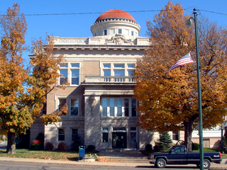
Warren County is a county in the U.S. state of Indiana. It lies in the western part of the state between the Illinois state line and the Wabash River. According to the 2020 census, it had a population of 8,440. Its county seat is Williamsport.

Angel Mounds State Historic Site, an expression of the Mississippian culture, is an archaeological site managed by the Indiana State Museum and Historic Sites that includes more than 600 acres of land about 8 miles (13 km) southeast of present-day Evansville, in Vanderburgh and Warrick counties in Indiana. The large residential and agricultural community was constructed and inhabited from AD 1100 to AD 1450, and served as the political, cultural, and economic center of the Angel chiefdom. It extended within 120 miles (190 km) of the Ohio River valley to the Green River in present-day Kentucky. The town had as many as 1,000 inhabitants inside the walls at its peak, and included a complex of thirteen earthen mounds, hundreds of home sites, a palisade (stockade), and other structures.

The history of Indianapolis spans three centuries. Founded in 1820, the area where the city now stands was originally home to the Lenape. In 1821, a small settlement on the west fork of the White River at the mouth of Fall Creek became the county seat of Marion County, and the state capital of Indiana, effective January 1, 1825. Initially the availability of federal lands for purchase in central Indiana made it attractive to the new settlement; the first European Americans to permanently settle in the area arrived around 1819 or early 1820. In its early years, most of the new arrivals to Indianapolis were Europeans and Americans with European ancestry, but later the city attracted other ethnic groups. The city's growth was encouraged by its geographic location, 2 miles (3.2 km) northwest of the state's geographic center. In addition to its designation as a seat of government, Indianapolis's flat, fertile soil, and central location within Indiana and the Midwest, helped it become an early agricultural center. Its proximity to the White River, which provided power for the town's early mills in the 1820s and 1830s, and the arrival of the railroads, beginning in 1847, established Indianapolis as a manufacturing hub and a transportation center for freight and passenger service. An expanding network of roads, beginning with the early National Road and the Michigan Road, among other routes, connected Indianapolis to other major cities.

William Conner was an American trader, interpreter, military scout, community leader, entrepreneur, and politician. Although Conner initially established himself as a fur trader on the Michigan and Indiana frontiers, his business interests later expanded to include ownership of Indiana farms, mills, distilleries, and mercantile shops. He was also a land speculator. Conner served the American forces in several capacities during the War of 1812, and as an interpreter and witness at several treaty negotiations with Native American tribes that resulted their removal from Indiana and established the state's geographical boundaries.
Lyles or Lyles Station is an unincorporated community in Patoka Township, Gibson County, Indiana. The community dates from 1849, although its early settlers first arrived in the 1830s, and it was formally named Lyles Station in 1886 to honor Joshua Lyles, a free African American who migrated with his family from Tennessee to Indiana around 1837. Lyles Station is one of Indiana's early black rural settlements and the only one remaining. The rural settlement reached its peak in the years between 1880 and 1912, when major structures in the community included the railroad depot, a post office, a lumber mill, two general stores, two churches, and a school. By the turn of the twentieth century, Lyles Station had fifty-five homes, with a population of more than 800 people. The farming community never fully recovered from the Great Flood of 1913, which destroyed much of the town. Most of its residents left for economic reasons, seeking opportunities for higher paying jobs and additional education in larger cities. By 1997 approximately fifteen families remained at Lyles Station, nearly all of them descended from the original settlers.
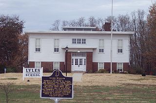
Lyles Consolidated School is a historic school in Lyles Station, Indiana. The third school to be located in Lyles Station, it was opened in 1919 and used until 1958. Abandoned for nearly forty years, it had deteriorated almost to the point of total collapse by 1997. The Lyles Station Historic Preservation Corporation was founded in June 1997, to preserve and promote the history of the Lyles Station community. Its major project was restoration of the schoolhouse, intending to use it as a living history museum to educate others both about Lyles Station's history and the daily school routine in the early twentieth century. The school was listed on the National Register of Historic Places in 1999. Restoration of the site was completed in 2003.

Wayne Township is one of thirteen townships in Henry County, Indiana, United States. As of the 2010 census, its population was 4,216 and it contained 1,828 housing units.

Shelby Township is one of ten townships in Jefferson County, Indiana, United States. As of the 2010 census, its population was 1,133 and it contained 453 housing units.
The Charles A. Beard Memorial School Corporation, named after historian Charles A. Beard, is a public school corporation located in southwestern Henry County, Indiana and serving Knightstown and surrounding areas. The district was formed in 1963 through the consolidation of schools in Wayne and Greensboro townships. Ripley Township, in neighboring Rush County, would later be added.
Lancaster is an unincorporated community in Lancaster Township, Jefferson County, Indiana.

Volga is an unincorporated community in Smyrna Township, Jefferson County, Indiana. The name's origin is not known with certainty, but is believed to have been adopted from Volga in Russia. There were no Russian settlers in the area so the reason is not known.

The Underground Railroad in Indiana was part of a larger, unofficial, and loosely-connected network of groups and individuals who aided and facilitated the escape of runaway slaves from the southern United States. The network in Indiana gradually evolved in the 1830s and 1840s, reached its peak during the 1850s, and continued until slavery was abolished throughout the United States at the end of the American Civil War in 1865. It is not known how many fugitive slaves escaped through Indiana on their journey to Michigan and Canada. An unknown number of Indiana's abolitionists, anti-slavery advocates, and people of color, as well as Quakers and other religious groups illegally operated stations along the network. Some of the network's operatives have been identified, including Levi Coffin, the best-known of Indiana's Underground Railroad leaders. In addition to shelter, network agents provided food, guidance, and, in some cases, transportation to aid the runaways.

Roberts Chapel, is a non-denominational church that was originally built in 1847 at Roberts Settlement, one of Indiana's early black pioneer communities. The rural church, whose main building dates from 1858, is located near the present-day town of Atlanta in rural Jackson Township, Hamilton County, Indiana. The chapel was listed on the National Register of Historic Places in 1996.

The Bethel A.M.E. Church, known in its early years as Indianapolis Station or the Vermont Street Church, is a historic African Methodist Episcopal Church in Indianapolis, Indiana. Organized in 1836, it is the city's oldest African-American congregation. The three-story church on West Vermont Street dates to 1869 and was added to the National Register in 1991. The surrounding neighborhood, once the heart of downtown Indianapolis's African American community, significantly changed with post-World War II urban development that included new hotels, apartments, office space, museums, and the Indiana University–Purdue University at Indianapolis campus. In 2016 the congregation sold their deteriorating church, which will be used in a future commercial development. The congregation built a new worship center at 6417 Zionsville Road in Pike Township, Marion County, Indiana.
Weaver is an unincorporated community in Liberty Township, Grant County, Indiana. Weaver's first settlers were free people of color who migrated from North Carolina and South Carolina to Grant County in the early 1840s. The neighborhood was originally known as Crossroad; however, it was later renamed Weaver in honor of a prominent family of the community. The rural settlement reached its peak in the late 1800s, when its population reportedly reached 2,000. Many of its residents left the community for higher-paying jobs in larger towns during the Indiana's natural gas boom, but more than 100 families remained in the settlement in the early 1920s. Weaver, as with most of Indiana's black rural settlements, no longer exists as a self-contained community, but Weaver Cemetery remains as a community landmark.
Roberts Settlement was an early rural settlement in Jackson Township, Hamilton County, Indiana. Dating from the 1830s, its first settlers were free people of color, most of whom migrated from Beech Settlement, located 40 miles (64 km) southeast in rural Rush County, Indiana. Many of Roberts Settlement's early pioneers were born in eastern North Carolina and Virginia. Some of its settlers were ex-slaves. The neighborhood received its name from the large contingent of its residents who had the surname of Roberts. By the 1870s the farming community had a population of approximately 300 residents. In the late nineteenth and early twentieth centuries, the settlement's population began to decline, largely due to changing economic conditions that included rising costs of farming. Fewer than six families remained at the settlement by the mid-1920s. Most of Indiana's early black rural settlements, including Roberts Settlement, no longer exist. Roberts Chapel, listed on the National Register of Historic Places, serves as the site for the community's annual reunions of its friends and the descendants of former residents.
William Keemer was the victim of a racial terror spectacle lynching in 1875 in Greenfield, Indiana. Keemer, a Black man, was dragged from his jail cell in Hancock County, Indiana on June 25, 1875 by a white mob from Hancock, Shelby, and Rush counties. Keemer was hung at the Hancock County fairgrounds and over 1,000 people traveled to view the body. Keemer was arrested on June 24 for an alleged sexual assault against a white women in Carthage, Indiana. No trial was held for the alleged crime and William Keemer remains innocent. In 2021 a historical marker commemorating the anti-Black violence committed against Keemer was approved by the Indiana Historical Bureau.
References
- Arnold, Eleanor, ed. (1972). Rush County History, 1822–1972. Rushville, Indiana: Rush County Sesquicentennial, Inc. OCLC 1505137.
- Atlas of Rush County, Indiana, to which are added various general maps, history, statistics, illustrations. Chicago: J. H. Beers and Company. 1879. OCLC 5944360. (Knightstown, Indiana: The Bookmark, 1974 reprint edition)
- "Beech Homecoming". Black History News and Notes. Indianapolis: Indiana Historical Society (3): 1. October 1980.
- Cord, Xenia (February 1987). "Black Rural Settlements in Indiana Before 1860". Black History News and Notes. Indianapolis: Indiana Historical Society (27): 4–8.
- "Early Black Settlements: Rush County". Indiana Historical Society. Archived from the original on March 6, 2016. Retrieved February 26, 2016.
- Elijah Roberts Collection, 1832–1972 Collection Guide (PDF). Indianapolis: Indiana Historical Society. 1994.
- Gulde, William F. (May 1991). "Rushville's African-American Community: An Historic Overview". Black History News and Notes. Indianapolis: Indiana Historical Society (44): 4–8.
- "Indiana's Black Pioneers". Black History News and Notes. Indianapolis: Indiana Historical Society (1): 1–2. October 1979.
- Jacobi, Lori B. (February 1988). "More than a Church: The Educational Role of the African Methodist Episcopal Church in Indiana, 1844–1861". Black History News and Notes. Indianapolis: Indiana Historical Society (31): 4–8.
- Madison, James H. (2014). Hoosiers: A New History of Indiana. Bloomington and Indianapolis: Indiana University Press and the Indiana Historical Society Press. ISBN 978-0-253-01308-8.
- Mount Pleasant Library (Rush County, Ind.) Records, 1842–1869, Collection Guide (PDF). Indianapolis: Indiana Historical Society. 2004.
- O'Bryan, Ann (November 2005). "Mt. Pleasant Library: Reading Among African Americans in 19th-Century Rush County, Indiana". Black History News and Notes. Indianapolis: Indiana Historical Society (102): 3–7.
- Robbins, Coy D. (August 1995). "Updating the African and Native American Legends in the Roberts Genealogy". Black History News and Notes. Indianapolis: Indiana Historical Society (61): 3–7.
- Rush County Interim Report. Indianapolis: Historic Landmarks Foundation of Indiana. 1993. OCLC 18997509.
- Sterling Watkins Family Papers, 1825–1987, Collection Guide (PDF). Indianapolis: Indiana Historical Society. 2007.
- Vincent, Stephen A. (1999). Southern Seed, Northern Soil: African-American Farm Communities in the Midwest, 1765–1900. Midwestern History and Culture. Bloomington: Indiana University Press. ISBN 9780253335777.
- Winslow Family Photographs, ca. 1890–ca. 1920, Collection Guide (PDF). Indianapolis: Indiana Historical Society. 2003.
Municipalities and communities of Rush County, Indiana, United States | ||
|---|---|---|
| City |  | |
| Towns | ||
| Townships | ||
| CDPs | ||
| Other communities | ||
| Footnotes | ‡This populated place also has portions in an adjacent county or counties | |