Bennett, Colorado

Last updated

Bennett, Colorado
Bennettcoskyline.JPG
Bennett skyline (2007)
Adams County and Arapahoe County Colorado Incorporated and Unincorporated areas Bennett Highlighted 0806090.svg
Location of Bennett in Adams and Arapahoe counties of Colorado
Coordinates: 39°44′46″N104°26′34″W / 39.745990°N 104.442841°W / 39.745990; -104.442841 [2]
Country Flag of the United States.svg  United States
State Flag of Colorado.svg  Colorado
Counties Adams County [1]
Arapahoe County
Incorporated (town) January 22, 1930 [3]
Government
  Type Statutory Town [1]
  MayorRoyce Pindell [4]
Area
[5]
  Total5.801 sq mi (15.024 km2)
  Land5.795 sq mi (15.008 km2)
  Water0.006 sq mi (0.016 km2)
Elevation
[6]
5,485 ft (1,672 m)
Population
 (2020) [5]
  Total2,862
  Density494/sq mi (191/km2)
Time zone UTC−07:00 (MST)
  Summer (DST) UTC−06:00 (MDT)
ZIP code
80102 [7]
Area codes Both 303 and 720
FIPS code 08-06090
GNIS feature ID204738
Website townofbennett.colorado.gov

Bennett is a Statutory Town located in Adams and Arapahoe counties, Colorado, United States. [1] The town population was 2,862 at the 2020 United States Census with 2,443 residing in Adams County and 419 residing in Arapahoe County. [5]

Contents

History

Bennett was incorporated on January 22, 1930, and was named for Hiram Pitt Bennet, congressional delegate from the Territory of Colorado and Colorado Secretary of State. [8]

Kiowa Crossing and train wreck

Until 1878, the town was known as Kiowa Crossing. On May 21 of that year, a heavy rainstorm washed out the railroad bridge over Kiowa Creek to the east of town. A Kansas Pacific Railway train of 25 cars loaded with scrap iron was washed into the stream with crewmen Frank Seldon, George Piatt, and John Bacon on board. Most of the wrecked train was recovered, but the locomotive #51 was never officially found. The story of the lost locomotive inspired Clive Cussler to write Night Probe! ; Later, in 1989, his nonprofit NUMA searched for the locomotive with no luck, as it turned out the locomotive wasn't there to find. That same year, archivist Lloyd Glasier at Union Pacific discovered that the railroad had found the locomotive, secretly lifted it to the surface and towed it to their workshop, where they rebuilt it, put it back into service with a new number, and collected the insurance money for its loss in an insurance fraud. [9]

Colorado spam king

Edward Davidson, known also as the "Colorado Spam King", operated an illegal spamming company, Power promotions, from July 2002 through April 2007 from a home near Bennett where he had a large network of computers and servers, according to federal authorities. The spam contained false header information, concealing the actual sender from the recipient of the e-mail. Davidson provided spammed messages for about 19 different companies, prosecutors said. Some of the e-mailed pitches were used to dupe stock investors and manipulate the market, federal authorities said. Davidson was sentenced to 21 months in federal prison and ordered to pay $714,139 to the Internal Revenue Service.[ citation needed ] On July 20, 2008, he escaped from a minimum-security prison. Four days later, he was found dead with his wife and a child, both also dead, in an apparent murder-suicide near Bennett. [10]

Geography

Bennett is located at 39°45′13″N104°25′43″W / 39.75361°N 104.42861°W / 39.75361; -104.42861 (39.753604, -104.428580), [11] at the intersection of State Highways 36 and 79, just north of Interstate 70.

At the 2020 United States Census, the town had a total area of 3,713 acres (15.024 km2) including 4.0 acres (0.016 km2) of water. [5]

The highest temperature ever recorded in Colorado occurred in Bennett on July 11, 1888, when it reached 118 °F (48 °C). [12] However, climatologists say this reading is an error because the temperature in downtown Denver on that day reached 100 degrees and it would be nearly impossible for it to be 18 degrees hotter just 30 miles east. [13]

Demographics

Historical population
CensusPop.Note
1930 211
1940 199−5.7%
1950 27236.7%
1960 2875.5%
1970 613113.6%
1980 94253.7%
1990 1,75786.5%
2000 2,02115.0%
2010 2,30814.2%
2020 2,86224.0%
U.S. Decennial Census

Bennett is a part of the Denver-Aurora-Lakewood, CO Metropolitan Statistical Area and the Front Range Urban Corridor.

As of the census [14] of 2000, there were 2,021 people, 715 households, and 539 families residing in the town. The population density was 652.3 inhabitants per square mile (251.9/km2). There were 732 housing units at an average density of 236.3 per square mile (91.2/km2). The racial makeup of the town was 94.56% White, 0.49% African American, 0.74% Native American, 0.30% Asian, 0.15% Pacific Islander, 1.63% from other races, and 2.13% from two or more races. Hispanic or Latino of any race were 4.45% of the population.

There were 715 households, out of which 49.2% had children under the age of 18 living with them, 58.3% were married couples living together, 10.9% had a female householder with no husband present, and 24.5% were non-families. 21.0% of all households were made up of individuals, and 6.7% had someone living alone who was 65 years of age or older. The average household size was 2.83 and the average family size was 3.30.

In the town, the population was spread out, with 34.5% under the age of 18, 7.0% from 18 to 24, 34.7% from 25 to 44, 18.1% from 45 to 64, and 5.6% who were 65 years of age or older. The median age was 31 years. For every 100 females, there were 103.7 males. For every 100 females age 18 and over, there were 97.8 males.

The median income for a household in the town was $46,600, and the median income for a family was $50,881. Males had a median income of $38,672 versus $26,354 for females. The per capita income for the town was $17,905. About 3.7% of families and 5.8% of the population were below the poverty line, including 5.9% of those under age 18 and 8.9% of those age 65 or over.

Notable people

See also

Related Research Articles

<span class="mw-page-title-main">Douglas County, Colorado</span> County in Colorado, United States

Douglas County is a county located in the U.S. state of Colorado. As of the 2020 Census, the population was 357,978. The county is named in honor of U.S. Senator Stephen A. Douglas. The county seat is Castle Rock.

<span class="mw-page-title-main">Adams County, Colorado</span> County in Colorado, United States

Adams County is a county located in the U.S. state of Colorado. As of the 2020 census, the population was 519,572. The county seat is Brighton, and the largest city is Thornton. The county is named for Alva Adams, an early Governor of the State of Colorado in 1887–1889. Adams County is part of the Denver–Aurora–Lakewood, CO Metropolitan Statistical Area.

<span class="mw-page-title-main">Elbert County, Colorado</span> County in the United States

Elbert County is a county located in the U.S. state of Colorado. As of the 2020 census, the population was 26,062. The county seat is Kiowa and the largest town is Elizabeth.

<span class="mw-page-title-main">Arapahoe County, Colorado</span> County in Colorado, United States

Arapahoe County is a county located in the U.S. state of Colorado. As of the 2020 census, its population was 655,070, making it the third-most populous county in Colorado. The county seat is Littleton, and the most populous city is Aurora. The county was named for the Arapaho Native American tribe, who once lived in the region.

<span class="mw-page-title-main">Bow Mar, Colorado</span> Town in Colorado, United States

Bow Mar is a Statutory Town located in Arapahoe and Jefferson counties, Colorado, United States. The town population was 853 at the 2020 United States Census with 587 residing in Arapahoe County and 266 residing in Jefferson County. Bow Mar is part of the Front Range Urban Corridor. The current mayor of Bow Mar is Bryan Sperry.

<span class="mw-page-title-main">Cherry Hills Village, Colorado</span> City in Colorado, United States

The City of Cherry Hills Village is a home rule municipality located in Arapahoe County, Colorado, United States. The city population was 6,442 at the 2020 United States Census. Cherry Hills Village is a part of the Denver–Aurora–Lakewood, CO Metropolitan Statistical Area and the Front Range Urban Corridor.

<span class="mw-page-title-main">Columbine Valley, Colorado</span> Town in Colorado, United States

The Town of Columbine Valley is a Statutory Town located in western Arapahoe County, Colorado, United States. The town population was 1,502 at the 2020 United States Census, a +19.59% increase since the 2010 United States Census. Columbine Valley is a part of the Denver-Aurora-Lakewood, CO Metropolitan Statistical Area and the Front Range Urban Corridor.

<span class="mw-page-title-main">Deer Trail, Colorado</span> Town in Colorado, United States

The Town of Deer Trail is a Statutory Town located in eastern Arapahoe County, Colorado, United States. The town population was 1,068 at the 2020 United States Census, a +95.60% increase since the 2010 United States Census. Deer Trail is a part of the Denver–Aurora–Lakewood, CO Metropolitan Statistical Area and the Front Range Urban Corridor. The town is situated along Interstate 70, approximately 55 miles (89 km) east of Denver.

<span class="mw-page-title-main">Foxfield, Colorado</span> Town in Colorado, United States

The Town of Foxfield is a statutory town located in Arapahoe County, Colorado, United States. The town population was 754 at the 2020 United States Census. Foxfield is a part of the Denver–Aurora–Lakewood, CO Metropolitan Statistical Area and the Front Range Urban Corridor. The town is bordered by the cities of Aurora and Centennial.

<span class="mw-page-title-main">Glendale, Colorado</span> City in Colorado, United States

The City of Glendale is a home rule municipality located in an exclave of Arapahoe County, Colorado, United States. The city population was 4,613 at the 2020 United States Census. Glendale is an enclave of the City and County of Denver and is the most densely populated municipality in Colorado. The city is a part of the Denver–Aurora–Lakewood, CO Metropolitan Statistical Area and the Front Range Urban Corridor.

<span class="mw-page-title-main">Greenwood Village, Colorado</span> City in Colorado, United States

The City of Greenwood Village is a home rule municipality located in Arapahoe County, Colorado, United States. The city population was 15,691 at the 2020 United States Census. Greenwood Village is a part of the Denver–Aurora–Lakewood, CO Metropolitan Statistical Area and the Front Range Urban Corridor.

<span class="mw-page-title-main">Castle Pines, Colorado</span> City in Colorado, United States

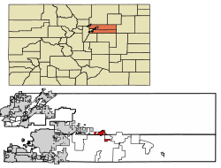
The City of Castle Pines is a home rule municipality located in Douglas County, Colorado, United States. The city population was 11,036 at the 2020 United States Census. Castle Pines is a part of the Denver–Aurora–Lakewood, CO Metropolitan Statistical Area and the Front Range Urban Corridor. The city is located north of the Town of Castle Rock and south of the City of Lone Tree, Colorado.

<span class="mw-page-title-main">Elizabeth, Colorado</span> Town in Elbert County, Colorado, United States

Elizabeth is a Statutory Town that is the most populous municipality in Elbert County, Colorado, United States. The town population was 1,675 at the 2020 United States Census, a +23.34% increase since the 2010 United States Census. Elizabeth is a part of the Denver–Aurora–Lakewood, CO Metropolitan Statistical Area and the Front Range Urban Corridor.

<span class="mw-page-title-main">Eads, Colorado</span> Town in Colorado, United States

Eads is the Statutory Town that is the county seat and the most populous municipality of Kiowa County, Colorado, United States. The town population was 672 at the 2020 United States Census.

<span class="mw-page-title-main">Dacono, Colorado</span> City in Colorado, United States

Dacono is a home rule municipality located in southwestern Weld County, Colorado, United States. The city population was 6,297 at the 2020 United States Census, an increase of +51.66% since the 2010 United States Census. Dacono is a part of the Greeley, CO Metropolitan Statistical Area and the Front Range Urban Corridor.

<span class="mw-page-title-main">Firestone, Colorado</span> Town in Colorado, United States

The Town of Firestone is a Statutory Town in southwestern Weld County, Colorado, United States. The town population was 16,381 at the 2020 United States Census, a 61.44% increase since the 2010 United States Census. Firestone is a part of the Greeley, CO Metropolitan Statistical Area and the Front Range Urban Corridor.

<span class="mw-page-title-main">Gilcrest, Colorado</span> Town in Colorado, United States

The Town of Gilcrest is a Statutory Town located in Weld County, Colorado, United States. The town population was 1,029 at the 2020 United States Census. Gilcrest is a part of the Greeley, CO Metropolitan Statistical Area and the Front Range Urban Corridor.

<span class="mw-page-title-main">Mead, Colorado</span> Town in Colorado, United States

The Town of Mead is a Statutory Town in Weld County, Colorado, United States. The town population was 4,781 at the 2020 United States Census.

<span class="mw-page-title-main">Kiowa, Kansas</span> City in Kiowa County, Kansas

Kiowa is a city in Barber County, Kansas, United States. As of the 2020 census, the population of the city was 902. It is located 1 mile north of the Kansas / Oklahoma state border.

<span class="mw-page-title-main">Littleton, Colorado</span> City in Colorado, United States

Littleton is a home rule municipality city located in Arapahoe, Douglas, and Jefferson counties, Colorado, United States. Littleton is the county seat of Arapahoe County and is a part of the Denver–Aurora–Lakewood, CO Metropolitan Statistical Area. The city population was 45,652 at the 2020 United States Census, ranking as the 20th most populous municipality in the State of Colorado.

References

  1. 1 2 3 4 "Active Colorado Municipalities". Colorado Department of Local Affairs . Retrieved October 15, 2021.
  2. "2014 U.S. Gazetteer Files: Places". United States Census Bureau. July 1, 2014. Retrieved January 5, 2015.
  3. "Colorado Municipal Incorporations". State of Colorado, Department of Personnel & Administration, Colorado State Archives. December 1, 2004. Retrieved August 18, 2007.
  4. "Town Board". Town of Bennett. Archived from [ townofbennett.colorado.gov the original] on September 28, 2007. Retrieved August 20, 2007.{{cite web}}: Check |url= value (help)
  5. 1 2 3 4 "Decennial Census P.L. 94-171 Redistricting Data". United States Census Bureau, United States Department of Commerce. August 12, 2021. Retrieved September 7, 2021.
  6. "US Board on Geographic Names". United States Geological Survey. October 25, 2007. Retrieved January 31, 2008.
  7. "ZIP Code Lookup". United States Postal Service. January 11, 2007. Archived from the original (JavaScript/HTML) on September 3, 2007. Retrieved January 11, 2007.
  8. Dawson, John Frank (1954). Place names in Colorado: why 700 communities were so named, 150 of Spanish or Indian origin. Denver, CO: The J. Frank Dawson Publishing Co. p. 9.[ permanent dead link ]
  9. "Lost Locomotive of Kiowa Creek". NUMA.net. Retrieved May 18, 2016.
  10. "'Spam King' Inmate Dies Along With Wife, Daughter". CBS4 Denver. July 24, 2008. Archived from the original on July 25, 2008.
  11. "US Gazetteer files: 2010, 2000, and 1990". United States Census Bureau. February 12, 2011. Retrieved April 23, 2011.
  12. "Record Highest Temperatures by State" (PDF). www.ncdc.noaa.gov. Archived from the original (PDF) on February 14, 2015. Retrieved June 9, 2015.
  13. "Colorado temperature record from 1888 is not valid". July 12, 2023.
  14. "U.S. Census website". United States Census Bureau . Retrieved January 31, 2008.
  15. "Town History". State of Colorado. Archived from the original on August 4, 2014. Retrieved August 31, 2012.