Bicknell, Indiana

Last updated

Bicknell, Indiana
Bicknell, Indiana.jpg
Knox County Indiana Incorporated and Unincorporated areas Bicknell Highlighted 1805176.svg
Location of Bicknell in Knox County, Indiana.
Coordinates: 38°46′25″N87°18′29″W / 38.77361°N 87.30806°W / 38.77361; -87.30806
Country United States
State Indiana
County Knox
Government
   Mayor Thomas Estabrook (D)
Area
[1]
  Total1.35 sq mi (3.50 km2)
  Land1.35 sq mi (3.50 km2)
  Water0.00 sq mi (0.00 km2)
Elevation
[2]
528 ft (161 m)
Population
 (2021)
  Total3,092
  Density2,238.73/sq mi (864.38/km2)
Time zone UTC-5 (EST)
  Summer (DST) UTC-4 (EDT)
ZIP code
47512
Area code 812, 930
FIPS code [2] [3] 18-05176
GNIS ID [2] [3] 431003

Bicknell is a city in Knox County, Indiana, United States. The population was 2,915 at the 2010 census.

Contents

History

Bicknell was laid out in 1869 by John Bicknell, and named for him. [4] [5]

Geography

Bicknell is located at 38°46′25″N87°18′29″W / 38.77361°N 87.30806°W / 38.77361; -87.30806 (38.773512, −87.307967). [6] It is located in northeastern Knox County.

According to the 2010 census, Bicknell has a total area of 1.35 square miles (3.50 km2), all land. [7]

Climate

The climate in this area is characterized by hot, humid summers and generally mild to cool winters. According to the Köppen Climate Classification system, Bicknell has a humid subtropical climate, abbreviated "Cfa" on climate maps. [8]

Demographics

Historical population
CensusPop.Note
1880 298
1910 2,794
1920 7,635173.3%
1930 5,212−31.7%
1940 5,110−2.0%
1950 4,572−10.5%
1960 3,878−15.2%
1970 3,717−4.2%
1980 4,71326.8%
1990 3,357−28.8%
2000 3,3780.6%
2010 2,915−13.7%
2020 3,0293.9%
U.S. Decennial Census [9]

2010 census

As of the 2010 census, [10] there were 2,915 people, 1,187 households, and 737 families living in the city. The population density was 2,159.3 inhabitants per square mile (833.7/km2). There were 1,501 housing units at an average density of 1,111.9 per square mile (429.3/km2). The racial makeup of the city was 97.6% White, 0.5% African American, 0.2% Native American, 0.2% Asian, 0.4% from other races, and 1.0% from two or more races. Hispanic or Latino of any race were 1.9% of the population.

There were 1,187 households, of which 31.1% had children under the age of 18 living with them, 44.5% were married couples living together, 12.6% had a female householder with no husband present, 5.1% had a male householder with no wife present, and 37.9% were non-families. 31.9% of all households were made up of individuals, and 14.5% had someone living alone who was 65 years of age or older. The average household size was 2.45 and the average family size was 3.10.

The median age in the city was 38.7 years. 25.1% of residents were under the age of 18; 9.3% were between the ages of 18 and 24; 23% were from 25 to 44; 26.3% were from 45 to 64; and 16.4% were 65 years of age or older. The gender makeup of the city was 48.7% male and 51.3% female.

2000 census

As of the 2000 census, [11] there were 3,378 people, 2,156 households, and 1,913 families living in the city. The population density was 2,216.8 inhabitants per square mile (855.9/km2). There were 1,581 housing units at an average density of 1,037.5 per square mile (400.6/km2). The racial makeup of the city was 98.13% White, 0.4% African American, 0.2% Native American, 0.15% Asian, 0.12% Pacific Islander, 0.06% from other races, and 0.89% from two or more races. Hispanic or Latino of any race were 0.25% of the population.

There were 1,395 households, out of which 29.9% had children under the age of 18 living with them, 49.2% were married couples living together, 12.6% had a female householder with no husband present, and 34.7% were non-families. 30.5% of all households were made up of individuals, and 16.2% had someone living alone who was 65 years of age or older. The average household size was 2.38 and the average family size was 2.95.

In the city, the population was spread out, with 25.3% under the age of 18, 8.7% from 18 to 24, 25.5% from 25 to 44, 23.1% from 45 to 64, and 17.4% who were 65 years of age or older. The median age was 38 years. For every 100 females, there were 89.9 males. For every 100 females age 18 and over, there were 84.5 males.

The median income for a household in the city was $23,046, and the median income for a family was $32,935. Males had a median income of $31,487 versus $58,162 for females. The per capita income for the city was $13,027. About 18.5% of families and 26.3% of the population were below the poverty line, including 38.4% of those under age 18 and 21.0% of those age 65 or over. The median age was 38.7

Government

Bicknell has a mayor-council system of government; both the mayor and city council serve four-year terms. There are five councilmen on the council, with four from districts and one at-large member.

Education

Bicknell has a public library, a branch of the Bicknell-Vigo Township Public Library. [12]

Notable people

Related Research Articles

<span class="mw-page-title-main">Brazil, Indiana</span> City in Indiana, United States

Brazil is a city in Clay County, Indiana, United States. The population was 8,181 at the 2020 census. The city is the county seat of Clay County. It is part of the Terre Haute Metropolitan Statistical Area.

<span class="mw-page-title-main">Alton, Indiana</span> Town in Indiana, United States

Alton is a town in Boone Township, Crawford County, Indiana, United States. The population was 29 at the 2020 census.

<span class="mw-page-title-main">Altona, Indiana</span> Town in Indiana, United States

Altona is a town in Keyser Township, DeKalb County, Indiana, United States. The population was 197 at the 2010 census.

<span class="mw-page-title-main">Albany, Indiana</span> Town in Indiana, United States

Albany is a town in Delaware and Randolph counties in the U.S. state of Indiana, along the Mississinewa River. The population was 2,295 at the 2020 census. It is part of the Muncie, IN Metropolitan Statistical Area.

<span class="mw-page-title-main">Blountsville, Indiana</span> Town in Indiana, United States

Blountsville is a town in Stoney Creek Township, Henry County, Indiana, United States. The population was 98 at the 2020 census.

<span class="mw-page-title-main">Edwardsport, Indiana</span> Town in Indiana, United States

Edwardsport is a town in Vigo Township, Knox County, Indiana, United States. The population was 303 at the 2010 census. It was founded in 1832 and named after Edward Wilkins, a founding father.

<span class="mw-page-title-main">Sandborn, Indiana</span> Town in Indiana, United States

Sandborn is a town in Vigo Township, Knox County, Indiana, United States. The population was 359 at the 2020 census. It is the home of the annual Black Creek Festival.

<span class="mw-page-title-main">Bedford, Indiana</span> City in Indiana, United States

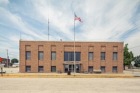
Bedford is a city in Shawswick Township and the county seat of Lawrence County, Indiana, United States. In the 2020 census, the population was 13,792. That is up from 13,413 in 2010. Bedford is the principal city of the Bedford, IN Micropolitan Statistical Area, which comprises all of Lawrence County.

<span class="mw-page-title-main">Alamo, Indiana</span> Town in Indiana, United States

Alamo is a town in Ripley Township, Montgomery County, in the U.S. state of Indiana. The population was 66 at the 2020 census, unchanged from 2010.

<span class="mw-page-title-main">Brooklyn, Indiana</span> Town in Indiana, United States

Brooklyn is a town in Clay and Brown townships, Morgan County, Indiana, United States. The population was 2,511 at the 2020 census, up from 1,598 in 2010.

<span class="mw-page-title-main">Albion, Indiana</span> Town in Indiana, United States

Albion is a town in Albion and Jefferson townships, Noble County, in the U.S. state of Indiana. The population was 2,349 at the 2010 census. The city is the county seat of Noble County.

<span class="mw-page-title-main">Avilla, Indiana</span> Town in Indiana, United States

Avilla is a town in Allen Township, Noble County, in the U.S. state of Indiana. The population was 2,401 at the 2010 census.

<span class="mw-page-title-main">Petersburg, Indiana</span> City in Indiana, United States

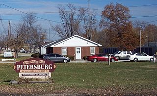
Petersburg is a city within Washington Township and the county seat of Pike County, in the U.S. state of Indiana. The population was 2,383 at the 2010 census.

<span class="mw-page-title-main">Austin, Indiana</span> City in Indiana, United States

Austin is a city in Jennings Township, Scott County, in the U.S. state of Indiana. The population was 4,272 at the 2000 census, at which time it was a town; Austin became a city on January 1, 2008. The population was 4,064 at the 2020 census.

<span class="mw-page-title-main">Boston, Indiana</span> Town in Indiana, United States

Boston is a town in Boston Township, Wayne County, Indiana, United States. The population was 138 at the 2010 census.

<span class="mw-page-title-main">Bluffton, Indiana</span> City in Indiana, United States

Bluffton is a city in Harrison and Lancaster townships, Wells County, in the U.S. state of Indiana. The population was 10,308 at the 2020 census, up from 9,897 at the 2010 census. The city is the county seat of Wells County and is the largest settlement. It is also part of Fort Wayne, Indiana's metropolitan area.

<span class="mw-page-title-main">Creighton, Nebraska</span> City in Nebraska, United States

Creighton is a city in Knox County, Nebraska, United States. The population was 1,154 at the 2010 census.

<span class="mw-page-title-main">Jefferson Township, Mercer County, Pennsylvania</span> Township in Pennsylvania, United States

Jefferson Township is a township in Mercer County, Pennsylvania, United States. The population was 1,920 at the 2020 census, an increase from 1,880 in 2010.

Pine Crest is a census-designated place (CDP) in Carter County, Tennessee, United States. The population was 2,388 at the 2010 census. It is part of the Johnson City Metropolitan Statistical Area, which is a component of the Johnson City–Kingsport–Bristol, TN-VA Combined Statistical Area – commonly known as the "Tri-Cities" region.

Elverta is a census-designated place in Sacramento County, California. It is part of the Sacramento metropolitan area, which includes Sacramento, Arden-Arcade, and Roseville. It is about 20 miles (32 km) from Sacramento, 2.5 miles (4.0 km) from Rio Linda, 6 miles (9.7 km) from Roseville, and 8.0 miles (12.9 km) from Antelope. The population was 5,492 as of the 2010 census.

References

  1. "2020 U.S. Gazetteer Files". United States Census Bureau. Retrieved March 16, 2022.
  2. 1 2 3 "Feature ID 431003". Geographic Names Information System . United States Geological Survey . Retrieved June 30, 2014.
  3. 1 2 "FIPS55 Data: Indiana". FIPS55 Data. United States Geological Survey. February 23, 2006. Archived from the original on June 18, 2006. Retrieved June 30, 2014.
  4. History of Knox and Daviess County, Indiana: From the Earliest Time to the Present. Goodspeed. 1886. pp.  266.
  5. Greene, George E. (1911). History of Old Vincennes and Knox County, Indiana. S.J. Clarke Publishing Company. p.  354.
  6. "US Gazetteer files: 2010, 2000, and 1990". United States Census Bureau. February 12, 2011. Retrieved April 23, 2011.
  7. "G001 - Geographic Identifiers - 2010 Census Summary File 1". United States Census Bureau. Archived from the original on February 13, 2020. Retrieved July 28, 2015.
  8. Climate Summary for Bicknell, Indiana
  9. "Census of Population and Housing". Census.gov. Retrieved June 4, 2015.
  10. "U.S. Census website". United States Census Bureau . Retrieved December 11, 2012.
  11. "U.S. Census website". United States Census Bureau . Retrieved January 31, 2008.
  12. "Bicknell Branch". Bicknell-Vigo Township Public Library. Retrieved March 8, 2018.