Monroe City, Indiana

Last updated

Monroe City, Indiana
Monroe City High School.JPG
Monroe City High School, now the Blue Jeans Community Center, Main Street, Monroe City.
Knox County Indiana Incorporated and Unincorporated areas Monroe City Highlighted 1850526.svg
Location of Monroe City in Knox County, Indiana.
Coordinates: 38°36′57″N87°21′19″W / 38.61583°N 87.35528°W / 38.61583; -87.35528
Country United States
State Indiana
County Knox
Township Harrison
Named for Monroe Alton
Area
[1]
  Total0.27 sq mi (0.70 km2)
  Land0.27 sq mi (0.70 km2)
  Water0.00 sq mi (0.00 km2)
Elevation
522 ft (159 m)
Population
 (2020)
  Total502
  Density1,866.17/sq mi (719.81/km2)
Time zone UTC-5 (EST)
  Summer (DST) UTC-4 (EDT)
ZIP code
47557
Area code 812
FIPS code 18-50526 [2]
GNIS feature ID0439342 [3]

Monroe City is a town in Harrison Township, Knox County, Indiana, United States. The population was 545 at the 2010 census.

Contents

Monroe City was named for one of its founders, Monroe Alton. [4] [5]

Geography

Monroe City is located at 38°36′57″N87°21′19″W / 38.61583°N 87.35528°W / 38.61583; -87.35528 (38.615891, -87.355232). [6]

According to the 2010 census, Monroe City has a total area of 0.27 square miles (0.70 km2), all land. [7]

Demographics

Historical population
CensusPop.Note
1880 401
1890 58946.9%
1900 68816.8%
1910 630−8.4%
1920 530−15.9%
1930 5442.6%
1940 518−4.8%
1950 453−12.5%
1960 50511.5%
1970 60319.4%
1980 569−5.6%
1990 538−5.4%
2000 5481.9%
2010 545−0.5%
2020 502−7.9%
U.S. Decennial Census [8]

2010 census

As of the census [9] of 2010, there were 545 people, 217 households, and 153 families living in the town. The population density was 2,018.5 inhabitants per square mile (779.3/km2). There were 238 housing units at an average density of 881.5 per square mile (340.3/km2). The racial makeup of the town was 98.7% White, 0.6% African American, 0.2% Native American, and 0.6% from other races. Hispanic or Latino of any race were 0.7% of the population.

There were 217 households, of which 37.8% had children under the age of 18 living with them, 53.0% were married couples living together, 14.3% had a female householder with no husband present, 3.2% had a male householder with no wife present, and 29.5% were non-families. 29.0% of all households were made up of individuals, and 13.8% had someone living alone who was 65 years of age or older. The average household size was 2.51 and the average family size was 3.08.

The median age in the town was 32.8 years. 28.8% of residents were under the age of 18; 8.2% were between the ages of 18 and 24; 29% were from 25 to 44; 20.7% were from 45 to 64; and 13.2% were 65 years of age or older. The gender makeup of the town was 47.3% male and 52.7% female.

2000 census

As of the census [2] of 2000, there were 548 people, 231 households, and 157 families living in the town. The population density was 2,039.4 inhabitants per square mile (787.4/km2). There were 259 housing units at an average density of 963.9 per square mile (372.2/km2). The racial makeup of the town was 99.27% White, 0.18% African American, and 0.55% from two or more races. Hispanic or Latino of any race were 0.36% of the population.

There were 231 households, out of which 32.9% had children under the age of 18 living with them, 53.7% were married couples living together, 11.3% had a female householder with no husband present, and 32.0% were non-families. 31.2% of all households were made up of individuals, and 16.9% had someone living alone who was 65 years of age or older. The average household size was 2.36 and the average family size was 2.94.

In the town, the population was spread out, with 24.6% under the age of 18, 8.4% from 18 to 24, 26.8% from 25 to 44, 22.6% from 45 to 64, and 17.5% who were 65 years of age or older. The median age was 39 years. For every 100 females, there were 93.6 males. For every 100 females age 18 and over, there were 90.3 males.

The median income for a household in the town was $32,788, and the median income for a family was $43,125. Males had a median income of $31,364 versus $18,269 for females. The per capita income for the town was $15,579. About 7.2% of families and 7.1% of the population were below the poverty line, including 9.0% of those under age 18 and 2.0% of those age 65 or over.

Related Research Articles

<span class="mw-page-title-main">Donovan, Illinois</span> Village in Illinois, United States

Donovan is a village in Beaver Township, Iroquois County, Illinois, United States. The population was 304 at the 2010 census.

<span class="mw-page-title-main">Monroe, Adams County, Indiana</span> Town in Indiana, United States

Monroe is a town in Washington and Monroe townships, Adams County, Indiana, United States. The population of the town was 945 residents at the 2019 census. Adams Central Community Schools is located in Monroe.

<span class="mw-page-title-main">Paragon, Indiana</span> Town in Indiana, United States

Paragon is a town in Ray Township, Morgan County, in the U.S. state of Indiana. The population was 556 at the 2020 census, down from 659 in 2010.

<span class="mw-page-title-main">Brooks, Maine</span> Town in the state of Maine, United States

Brooks is a town in Waldo County, Maine, United States. The population was 1,010 at the 2020 census.

<span class="mw-page-title-main">Monroe, Maine</span> Town in the state of Maine, United States

Monroe is a town in Waldo County, Maine, United States named for President James Monroe. The population was 931 at the 2020 census.

<span class="mw-page-title-main">Millis-Clicquot, Massachusetts</span> CDP in Massachusetts, United States

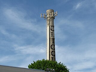
Millis-Clicquot is a census-designated place (CDP) in the town of Millis in Norfolk County, Massachusetts, United States. The population was 4,403 at the 2010 census. The name "Clicquot" comes from the now-defunct Clicquot Club Company, a beverage manufacturer that was founded in the area in 1881.

<span class="mw-page-title-main">Forest Township, Cheboygan County, Michigan</span> Civil township in Michigan, United States

Forest Township is a civil township of Cheboygan County in the U.S. state of Michigan. The population was 977 at the 2020 census.

<span class="mw-page-title-main">Hickory Flat, Mississippi</span> Town in Mississippi, United States

Hickory Flat is a town in Benton County, Mississippi, United States. The population was 601 at the 2010 census.

<span class="mw-page-title-main">Old Monroe, Missouri</span> City in Lincoln County, Missouri, US

Old Monroe is a city in Lincoln County, Missouri, United States. The population was 249 at the 2020 census.

<span class="mw-page-title-main">Monroe, Oregon</span> City in Benton County, Oregon

Monroe is a city in Benton County, Oregon, United States. The population was 651 at the 2018 census. It is part of the Corvallis, Oregon Metropolitan Statistical Area. Monroe is located midway between Eugene and Corvallis along Highway 99W.

<span class="mw-page-title-main">Portage Township, Potter County, Pennsylvania</span> Township in Pennsylvania, United States

Portage Township is a township in Potter County, Pennsylvania, United States. The population was 163 at the 2020 census.

<span class="mw-page-title-main">Monroe, South Dakota</span> Town in South Dakota, United States

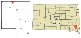
Monroe is a town in Turner County, South Dakota, United States. The population was 159 at the 2020 census.

<span class="mw-page-title-main">Ramer, Tennessee</span> City in McNairy County, Tennessee, United States

Ramer is a city in McNairy County, Tennessee. The population was 354 at the 2000 census.

<span class="mw-page-title-main">Peterstown, West Virginia</span> Town in West Virginia, United States

Peterstown is a town in Monroe County, West Virginia, United States. The population was 456 at the 2020 census.

<span class="mw-page-title-main">Monroe, Adams County, Wisconsin</span> Town in Wisconsin, United States

Monroe is a town in Adams County in the U.S. state of Wisconsin. The population was 398 as of the 2010 census. In 2019 this figure was 10,625. The unincorporated community of Monroe Center is located in the town.

<span class="mw-page-title-main">Portland, Monroe County, Wisconsin</span> Town in Wisconsin, United States

The Town of Portland is located in Monroe County, Wisconsin, United States. The population was 686 at the 2000 census. According to a census taken in 2021,the population was 202, 35.8 square mile with about 26.6 people per square mile

<span class="mw-page-title-main">Scott, Monroe County, Wisconsin</span> Town in Wisconsin, United States

The Town of Scott is located in Monroe County, Wisconsin, United States. The population was 117 at the 2000 census. The unincorporated community of Norway Ridge is located in the town.

<span class="mw-page-title-main">Monroe, Ohio</span> City in Ohio, United States

Monroe is a city in east central Butler and west central Warren counties in the southwestern part of the U.S. state of Ohio. The population was 15,412 at the 2020 census. Monroe is a part of the Cincinnati metropolitan area.

<span class="mw-page-title-main">Naples (village), New York</span> Village in New York, United States

Naples is a village in Ontario County, New York, United States. The population was 1,041 at the 2010 census. It is a part of the Town of Naples, known as an important grape-growing region.

Kennan is a town in Price County, Wisconsin, United States. The population was 378 at the 2000 census. The Village of Kennan is located within the town.

References

  1. "2020 U.S. Gazetteer Files". United States Census Bureau. Retrieved March 16, 2022.
  2. 1 2 "U.S. Census website". United States Census Bureau . Retrieved January 31, 2008.
  3. "US Board on Geographic Names". United States Geological Survey. October 25, 2007. Retrieved January 31, 2008.
  4. Baker, Ronald L. (October 1995). From Needmore to Prosperity: Hoosier Place Names in Folklore and History . Indiana University Press. p.  225. ISBN   978-0-253-32866-3. ...name is for Monroe Alton, proprietor.
  5. Gannett, Henry (1905). The Origin of Certain Place Names in the United States. U.S. Government Printing Office. p.  212.
  6. "US Gazetteer files: 2010, 2000, and 1990". United States Census Bureau. February 12, 2011. Retrieved April 23, 2011.
  7. "G001 - Geographic Identifiers - 2010 Census Summary File 1". United States Census Bureau. Archived from the original on February 13, 2020. Retrieved July 17, 2015.
  8. "Census of Population and Housing". Census.gov. Retrieved June 4, 2015.
  9. "U.S. Census website". United States Census Bureau . Retrieved December 11, 2012.