Westphalia, Indiana

Last updated

Westphalia, Indiana
Knox County Indiana Incorporated and Unincorporated areas Westphalia Highlighted 1883204.svg
Location in Knox County, Indiana
USA Indiana location map.svg
Red pog.svg
Westphalia
Usa edcp location map.svg
Red pog.svg
Westphalia
Coordinates: 38°51′46″N87°13′32″W / 38.86278°N 87.22556°W / 38.86278; -87.22556
Country United States
State Indiana
County Knox
Township Vigo
Named for Westphalia
Area
[1]
  Total2.06 sq mi (5.34 km2)
  Land2.06 sq mi (5.34 km2)
  Water0.00 sq mi (0.00 km2)
Elevation
[2]
466 ft (142 m)
Population
 (2020)
  Total181
  Density87.78/sq mi (33.89/km2)
Time zone UTC-5 (EST)
  Summer (DST) UTC-4 (EDT)
ZIP code
47596
FIPS code 18-83204 [3]
GNIS feature ID 445855

Westphalia is an unincorporated community and census-designated place (CDP) in Vigo Township, Knox County, Indiana. As of the 2010 census it had a population of 202. [4]

Contents

History

Westphalia was laid out in 1881, and it was originally built up chiefly by Germans. [5] It was named after the region of Westphalia in Germany. [6] The Westphalia post office was established in 1881. [7] Many businesses have existed over the history of Westphalia including a variety store, antique store, hotel, blacksmith, elevator, photo studio, mine supply and the Westphalia elementary school.

Geography

Westphalia is located in northeastern Knox County at 38°51′46″N87°13′32″W / 38.86278°N 87.22556°W / 38.86278; -87.22556 . Indiana State Road 67 passes through the center of the community, leading northeast 3 miles (5 km) to Sandborn and southwest 4 miles (6 km) to Edwardsport and 23 miles (37 km) to Vincennes, the Knox county seat. Indiana State Road 58 joins SR 67 northeast out of Westphalia but leads west 5 miles (8 km) to Freelandville.

According to the U.S. Census Bureau, the Westphalia CDP has an area of 2.06 square miles (5.34 km2), all of it land. [4]

Demographics

Historical population
CensusPop.Note
2020 181
U.S. Decennial Census [8]

Places of interest

Westphalia has a playground, a church (Salem United Church of Christ), low income senior apartments and a post office. Westphalia is a rural community.

Related Research Articles

<span class="mw-page-title-main">Knox County, Indiana</span> County in Indiana, United States

Knox County is a county in the U.S. state of Indiana in the United States. The oldest county in Indiana, it was one of two original counties created in the Northwest Territory in 1790, alongside St. Clair County, Illinois. Knox County was gradually reduced in size as subsequent counties were established. It was established in its present configuration when Daviess County was partitioned off. At the 2020 United States Census, the county population was 36,282. The county seat is Vincennes.

<span class="mw-page-title-main">Sandborn, Indiana</span> Town in Indiana, United States

Sandborn is a town in Vigo Township, Knox County, Indiana, United States. The population was 359 at the 2020 census. It is the home of the annual Black Creek Festival.

<span class="mw-page-title-main">Lakes of the Four Seasons, Indiana</span> Census-designated place in Indiana, United States

Lakes of the Four Seasons is a census-designated place (CDP) in Lake and Porter counties in the U.S. state of Indiana. The population was 7,033 at the 2010 census.

<span class="mw-page-title-main">Koontz Lake, Indiana</span> Census-designated place in Indiana, United States

Koontz Lake is an unincorporated community and census-designated place (CDP) in Starke and Marshall counties, in the U.S. state of Indiana. The population was 1,667 at the 2020 census.

<span class="mw-page-title-main">Mascot, Tennessee</span> CDP in Tennessee, United States

Mascot is a census-designated place (CDP) in Knox County, Tennessee. The population was 2,760 at the 2020 census up from 2,411 at the 2010 census.

<span class="mw-page-title-main">Seymour, Tennessee</span> CDP in Tennessee, United States

Seymour is a census-designated place (CDP) and unincorporated community in Blount and Sevier counties in the U.S. state of Tennessee. The CDP population was 14,705 at the 2020 U.S. census. It is included in the Knoxville, Tennessee Metropolitan Statistical Area.

<span class="mw-page-title-main">Canaan, Indiana</span> Census-designated place in Indiana, United States

Canaan is an unincorporated community and census-designated place (CDP) in Shelby Township, Jefferson County, Indiana, United States. As of the 2010 census it had a population of 90.

<span class="mw-page-title-main">Coalmont, Indiana</span> Census-designated place in Indiana, United States

Coalmont is an unincorporated community and census-designated place in Lewis Township, Clay County, Indiana, United States. It is part of the Terre Haute Metropolitan Statistical Area. As of the 2010 census it had a population of 402.

<span class="mw-page-title-main">Raglesville, Indiana</span> Census-designated place in Indiana, United States

Raglesville is an unincorporated community and census-designated place (CDP) in Van Buren Township, Daviess County, Indiana, United States. As of the 2010 census it had a population of 141.

Centerton is an unincorporated community and census-designated place (CDP) in Clay Township, Morgan County, in the U.S. state of Indiana.

<span class="mw-page-title-main">Owensburg, Indiana</span> Census-designated place in Indiana, United States

Owensburg is an unincorporated community and census-designated place (CDP) in Jackson Township, Greene County, Indiana, United States. It was named in honor of the Owens family of early settlers. As of the 2010 census it had a population of 406.

<span class="mw-page-title-main">Scotland, Indiana</span> Census-designated place in Indiana, United States

Scotland is an unincorporated community and census-designated place (CDP) in Taylor Township, Greene County, Indiana, United States. As of the 2010 census it had a population of 134.

<span class="mw-page-title-main">Freetown, Indiana</span> Census-designated place in Indiana, United States

Freetown is an unincorporated community and census-designated place in Pershing Township, Jackson County, Indiana, United States. As of the 2010 census the population was 385.

Kent is an unincorporated community and census-designated place (CDP) in Republican Township, Jefferson County, Indiana, United States. As of the 2010 census it had a population of 70.

<span class="mw-page-title-main">Emison, Indiana</span> Census-designated place in Indiana, United States

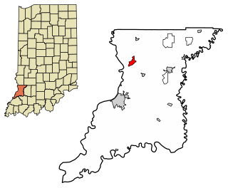
Emison is an unincorporated community and census-designated place (CDP) in Busseron Township, Knox County, Indiana. Its population was 154 at the 2010 census.

<span class="mw-page-title-main">Freelandville, Indiana</span> Census-designated place in Indiana, United States

Freelandville or Freelandsville is an unincorporated community and census-designated place in Widner Township, Knox County, Indiana, United States. As of the 2010 United States Census it had a population of 643.

<span class="mw-page-title-main">Ragsdale, Indiana</span> Census-designated place in Indiana, United States

Ragsdale is an unincorporated community and census-designated place in Washington Township, Knox County, Indiana. As of the 2010 census it had a population of 129.

North Grove is an unincorporated community and census-designated place (CDP) in Harrison Township, Miami County, in the U.S. state of Indiana.

<span class="mw-page-title-main">Stanford, Indiana</span> Census-designated place in Indiana, United States

Stanford is an unincorporated community and census-designated place (CDP) in Van Buren Township, Monroe County, in the U.S. state of Indiana.

<span class="mw-page-title-main">Landess, Indiana</span> Census-designated place in Indiana, United States

Landess is an unincorporated community and census-designated place (CDP) in Washington and Van Buren townships, Grant County, Indiana, in the United States. As of the 2010 census it had a population of 188.

References

  1. "2020 U.S. Gazetteer Files". United States Census Bureau. Retrieved March 16, 2022.
  2. "US Board on Geographic Names". United States Geological Survey. October 25, 2007. Retrieved January 31, 2008.
  3. "U.S. Census website". United States Census Bureau . Retrieved January 31, 2008.
  4. 1 2 "Geographic Identifiers: 2010 Demographic Profile Data (G001): Westphalia CDP, Indiana". American Factfinder. U.S. Census Bureau. Retrieved February 27, 2019.[ dead link ]
  5. History of Knox and Daviess County, Indiana: From the Earliest Time to the Present. Goodspeed. 1886. pp.  272.
  6. Dept. of English and Journalism (1970–72). Indiana names, v.1-3. Indiana State University. p. 15.
  7. "Knox County". Jim Forte Postal History. Retrieved November 25, 2014.
  8. "Census of Population and Housing". Census.gov. Retrieved June 4, 2016.