Biehle, Missouri

Last updated

Biehle, Missouri
Perry County Missouri Incorporated and Unincorporated areas Biehle Highlighted.svg
Location of Biehle, Missouri
Coordinates: 37°36′24″N89°50′16″W / 37.60667°N 89.83778°W / 37.60667; -89.83778
Country United States
State Missouri
County Perry
Township Cinque Hommes
IncorporatedMarch 13, 1992 [1]
DisincorporatedNovember 6, 2003 [1]
Area
[2]
  Total0.22 sq mi (0.57 km2)
  Land0.22 sq mi (0.57 km2)
  Water0.00 sq mi (0.00 km2)
Elevation
[3]
515 ft (157 m)
Population
 (2020)
  Total47
  Density211.71/sq mi (81.92/km2)
Time zone UTC-6 (Central (CST))
  Summer (DST) UTC-5 (CDT)
ZIP code
63775
Area code 573
FIPS code 29-05320
GNIS feature ID2587053 [3]

Biehle was a village in Perry County, Missouri, United States. The population was 47 at the 2020 census. The community was founded in 1876 and named after the Biehle family.

Contents

History

In the 1840s, German Catholic immigrants from the Baden region of Germany settled in the area first known as Biehle Station. One of the earliest settlers was a German immigrant named Maurus Biehle. In the 1850s, a log church was built on land donated by Maurus Biehle. In May 1869, a new stone church, St. Maurus Catholic Church, was dedicated for the German Catholic parish, and in January 1870, Father Joseph Hellwing became the first full-time priest.[ citation needed ]

In 1925, the Tri-State Tornado struck the community, ripping the roof off a church, destroying many houses, and killing four people in town. [4] The village disincorporated in 2003. [5]

Geography

Biehle is located along Missouri Route B on a ridge above a sharp bend in Apple Creek. The Perry-Cape Girardeau county line lies three-quarters of a mile south of the community. [6]

Biehle is located in Cinque Hommes township.

According to the United States Census Bureau, the CDP has a total area of 0.22 square miles (0.57 km2), all land. [7]

Demographics

Historical population
CensusPop.Note
2000 11
2010 48336.4%
2020 47−2.1%
U.S. Decennial Census [8] 2020 [9]

2010 census

As of the census [10] of 2010, there were 48 people, 19 households, and 12 families living in the village. The population density was 218.2 inhabitants per square mile (84.2/km2). There were 23 housing units at an average density of 104.5 per square mile (40.3/km2). The racial makeup of the village was 100.00% White.

There were 19 households, of which 36.8% had children under the age of 18 living with them, 42.1% were married couples living together, 15.8% had a female householder with no husband present, 5.3% had a male householder with no wife present, and 36.8% were non-families. 31.6% of all households were made up of individuals, and 10.6% had someone living alone who was 65 years of age or older. The average household size was 2.53 and the average family size was 3.17.

The median age in the CDP was 32.5 years. 27.1% of residents were under the age of 18; 10.5% were between the ages of 18 and 24; 29.2% were from 25 to 44; 25.1% were from 45 to 64; and 8.3% were 65 years of age or older. The gender makeup of the CDP was 47.9% male and 52.1% female.

2000 census

As of the census [11] of 2000, there were 11 people, 5 households, and 4 families living in the village. The population density was 113.1 inhabitants per square mile (43.7/km2). There were 5 housing units at an average density of 51.4 per square mile (19.8/km2). The racial makeup of the village was 100.00% White.

There were 5 households, out of which 20.0% had children under the age of 18 living with them, 80.0% were married couples living together, and 20.0% were non-families. 20.0% of all households were made up of individuals, and none had someone living alone who was 65 years of age or older. The average household size was 2.20 and the average family size was 2.50.

In the village, the population was spread out, with 9.1% under the age of 18, 9.1% from 18 to 24, 45.5% from 25 to 44, 18.2% from 45 to 64, and 18.2% who were 65 years of age or older. The median age was 40 years. For every 100 females, there were 120.0 males. For every 100 females age 18 and over, there were 150.0 males.

The median income for a household in the village was $31,875, and the median income for a family was $55,625. Males had a median income of $32,083 versus $0 for females. The per capita income for the village was $23,000. None of the population and none of the families were below the poverty line.

Location of nearby communities

Plaatsen in de omgeving Blank map.svg
Plaatsen in de omgeving
Map pointer black.svg Biehle
Small-city-symbol.svg Longtown (5.8 miles)
Small-city-symbol.svg Oak Ridge (9.4 miles)
Small-city-symbol.svg Old Appleton (7 miles)
Small-city-symbol.svg Perryville (8.3 miles)
Small-city-symbol.svg Sedgewickville (7.1 miles)

Related Research Articles

<span class="mw-page-title-main">Terramuggus, Connecticut</span> Census-designated place in Connecticut, United States

Terramuggus is a census-designated place (CDP) in the town of Marlborough, Hartford County, Connecticut, United States. It contains the town center village and surrounding areas. The population was 1,025 at the 2010 census.

<span class="mw-page-title-main">Plainfield Village, Connecticut</span> Village in Connecticut, United States

Plainfield Village is a village and census-designated place (CDP) in the town of Plainfield, Connecticut in the United States. The population was 2,557 at the 2010 census. It is located in the southwest part of town, in the area west of I-395 and south of Route 14. The village is also the core of the Plainfield, CT urban cluster.

<span class="mw-page-title-main">Gray Summit, Missouri</span> Census-designated place in Missouri, United States

Gray Summit is an unincorporated community and census-designated place (CDP) in Franklin County, Missouri, United States. The population was 2,701 at the 2010 census. Also called "Gray's Summit", it was founded by Daniel Gray of New York, who built a hotel here in 1845. It is located on Missouri Route 100 just north of Interstate 44.

<span class="mw-page-title-main">Villa Ridge, Missouri</span> Census-designated place in Missouri, United States

Villa Ridge is an unincorporated community and census-designated place (CDP) in Franklin County, Missouri, United States. The population was 2,636 at the 2010 census, up from 2,417 at the 2000 census.

<span class="mw-page-title-main">Hartwell, Missouri</span> Census-designated place in Missouri, US

Hartwell is a former village and census-designated place in Henry County, Missouri, United States. The population was 16 at the 2010 census.

<span class="mw-page-title-main">Evergreen, Missouri</span> Village in Missouri, United States

Evergreen is a village in Laclede County, Missouri, United States. The population was 28 at the 2010 census. It was named Twin Bridges at the 2000 census.

<span class="mw-page-title-main">Hayward, Missouri</span> Census-designated place in Missouri, United States

Hayward is a census-designated place and former village in Pemiscot County, Missouri, United States. The population was 131 at the 2010 census.

<span class="mw-page-title-main">Glasgow Village, Missouri</span> CDP in Missouri, United States

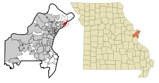
Glasgow Village is a census-designated place (CDP) in St. Louis County, Missouri, United States. The population was 5,429 at the 2010 census.

<span class="mw-page-title-main">Oakville, Missouri</span> CDP in Missouri, United States

Oakville is a census-designated place (CDP) in south St. Louis County, Missouri, United States. The population was 36,301 at the 2020 census. Oakville is 18 miles south of the city of St. Louis and borders the Mississippi and Meramec rivers; the area is part of "South County".

<span class="mw-page-title-main">Ashland, New Jersey</span> Populated place in Camden County, New Jersey, US

Ashland is an unincorporated community and census-designated place (CDP) located within Cherry Hill, in Camden County, in the U.S. state of New Jersey. As of the 2010 United States Census, the CDP's population was 8,302.

<span class="mw-page-title-main">Victory Lakes, New Jersey</span> Populated place in Gloucester County, New Jersey, US

Victory Lakes is an unincorporated community and census-designated place (CDP) located within Monroe Township, in Gloucester County, in the U.S. state of New Jersey. As of the 2010 United States Census, the CDP's population was 2,111.

<span class="mw-page-title-main">Princeton Meadows, New Jersey</span> Populated place in Middlesex County, New Jersey, US

Princeton Meadows is an unincorporated community and census-designated place (CDP) located within Plainsboro Township, in Middlesex County, in the U.S. state of New Jersey. As of the 2010 United States Census, the CDP's population was 13,834.

<span class="mw-page-title-main">Shark River Hills, New Jersey</span> Populated place in Monmouth County, New Jersey, US

Shark River Hills is an unincorporated community and census-designated place (CDP) within Neptune Township, in Monmouth County, in the U.S. state of New Jersey. As of the 2010 United States Census, the CDP's population was 3,697.

<span class="mw-page-title-main">Lake Telemark, New Jersey</span> Populated place in Morris County, New Jersey, US

Lake Telemark is an unincorporated community and census-designated place (CDP) located within Rockaway Township, in Morris County, in the U.S. state of New Jersey. As of the 2010 United States Census, the CDP's population was 1,255.

<span class="mw-page-title-main">Crestwood Village, New Jersey</span> CDP in Ocean County, New Jersey, US

Crestwood Village is an unincorporated community and census-designated place (CDP) located within Manchester Township, in Ocean County, in the U.S. state of New Jersey. As of the 2010 United States Census, the CDP's population was 7,907.

<span class="mw-page-title-main">Holiday City South, New Jersey</span> Populated place in Ocean County, New Jersey, US

Holiday City South is an unincorporated community and census-designated place (CDP) located within Berkeley Township, in Ocean County, in the U.S. state of New Jersey. As of the 2010 United States Census, the CDP's population was 3,689.

<span class="mw-page-title-main">Leisure Village East, New Jersey</span> Populated place in Ocean County, New Jersey, US

Leisure Village East is an unincorporated community and census-designated place (CDP) located within Lakewood Township, in Ocean County, in the U.S. state of New Jersey. As of the 2010 United States Census, the CDP's population was 4,217. Leisure Village East is one of several active adult communities bearing similar names. Leisure Village and Leisure Village West are the other two communities nearby.

<span class="mw-page-title-main">Olivet, New Jersey</span> Populated place in Salem County, New Jersey, US

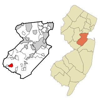
Olivet is an unincorporated community and census-designated place (CDP) located within Pittsgrove Township, in Salem County, in the U.S. state of New Jersey. As of the 2010 United States Census, the CDP's population was 1,408.

<span class="mw-page-title-main">Brass Castle, New Jersey</span> Populated place in Warren County, New Jersey, US

Brass Castle is an unincorporated community and census-designated place (CDP) located within Washington Township, in Warren County, in the U.S. state of New Jersey. As of the 2010 United States Census, the CDP's population was 1,555.

<span class="mw-page-title-main">Windsor, Wisconsin</span> Village in Wisconsin, United States

Windsor is a village and former town in Dane County, Wisconsin. The population was 8,754 at the time of the 2020 census. The communities of Lake Windsor, Morrisonville, and Token Creek are located within the village. Windsor voted to incorporate as a village on November 3, 2015; prior to its incorporation, it was a town, and a portion of the town was a census-designated place. Windsor is a part of the Census Bureau's Madison metropolitan statistical area.

References

  1. 1 2 Census.gov
  2. "ArcGIS REST Services Directory". United States Census Bureau. Retrieved December 19, 2022. Census - community changes 1990-1999
  3. 1 2 U.S. Geological Survey Geographic Names Information System: Biehle, Missouri
  4. Mississippi Valley Architecture.com http://www.krjarch.com/biehle.asp Archived 2013-08-25 at archive.today
  5. "Boundary Changes". Archived from the original on April 2, 2015. Retrieved November 13, 2016.
  6. Friedheim, MO 7.5 Minute Topographic Quadrangle, USGS, 1980 (1986 rev.)
  7. "US Gazetteer files 2010". United States Census Bureau. Archived from the original on January 12, 2012. Retrieved July 8, 2012.
  8. United States Census Bureau. "Census of Population and Housing".
  9. "2020 Census Data". data.census.gov.
  10. "U.S. Census website". United States Census Bureau . Retrieved July 8, 2012.
  11. U.S. Geological Survey Geographic Names Information System: Biehle, Missouri