The Platte River is a major river in the State of Nebraska. It is about 310 mi (500 km) long; measured to its farthest source via its tributary, the North Platte River, it flows for over 1,050 miles (1,690 km). The Platte River is a tributary of the Missouri River, which itself is a tributary of the Mississippi River which flows to the Gulf of Mexico. The Platte over most of its length is a broad, shallow, meandering stream with a sandy bottom and many islands—a braided stream.

A spring is a point of exit at which groundwater from an aquifer flows out on top of Earth's crust (pedosphere) and becomes surface water. It is a component of the hydrosphere. Springs have long been important for humans as a source of fresh water, especially in arid regions which have relatively little annual rainfall.
Siloam Springs is an unincorporated community in western Howell County, Missouri, United States. It is located approximately two miles south of Route 14 on Missouri Route T, just east of the southeastern corner of Douglas County and fifteen miles northwest of West Plains. Waters from the associated spring flow west and enter Tabor Creek, which then flows into Spring Creek, a tributary to the Norfork River in the southeast corner of Douglas County. The site is at an elevation of 1,060 ft (320 m).
Kramer is a small unincorporated community in Liberty Township, Warren County, in the U.S. state of Indiana.

Belknap Springs is an unincorporated community and private hot springs resort in Lane County, Oregon, United States, near the McKenzie River. The springs were located and initially developed by R. S. Belknap in 1869. A post office named "Salt Springs" was established in the location in 1874, and the name changed to "Belknap Springs" in 1875. The post office closed in 1877 and reopened in 1891, operating intermittently until 1953. Today the location uses a McKenzie Bridge mailing address.

Scovern Hot Springs is a thermal spring system, and former settlement in the Kern River Valley of the Southern Sierra Nevada, in Kern County, California.
Pinehurst is an unincorporated community in Jackson County, Oregon, United States, on Oregon Route 66 about 25 miles (40 km) southeast of Ashland. It is along Jenny Creek near Round Prairie between the Siskiyou Mountains and the foothills of the Cascade Range.

McCredie Springs are hot springs and a former resort in Lane County, Oregon, United States. It is located near Oregon Route 58, 10.7 miles (17.2 km) east of Oakridge, and 50.7 miles (81.6 km) east of Eugene, within the Willamette National Forest. It is known for the nearby natural hot springs along Salt Creek.
Ponce de Leon Springs was a mineral spring in Atlanta, Georgia, United States. The spring was a popular tourist destination from the mid-1800s through the early 1900s. Around the turn of the century, the land surrounding the spring was developed into an amusement park, though by the 1920s, the amusement park was demolished and the area was developed for industrial and, later, commercial properties.

Cinque Hommes is one of the eight townships located in Perry County, Missouri, in the United States of America.

Apple Creek is a stream that rises in western Perry County, Missouri and empties into the Mississippi River, forming the boundary between Perry and Cape Girardeau counties.
Mineral Springs is an unincorporated community in Adams County, Ohio.
Mineral Spring is an unincorporated community in Barry County, in the U.S. state of Missouri.
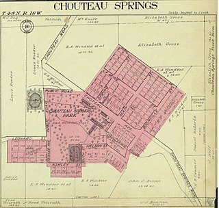
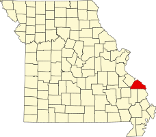
Chouteau Springs is an unincorporated community in Pilot Grove Township, Cooper County, in the U.S. state of Missouri.
Graydon Springs is an unincorporated community in Polk County, in the U.S. state of Missouri.
Randolph Springs is an unincorporated community in Randolph County, in the U.S. state of Missouri.
Fair Haven is an unincorporated community in Vernon County, in the U.S. state of Missouri.
White is an extinct town in Washington County, in the U.S. state of Missouri. The community was located on Keyes Branch near its confluence with Mill Creek along the railroad line. Cadet lies one mile to the north and Mineral Point is 2.5 south-southeast of the location.
Buckhorn Springs is an unincorporated community in Jackson County, Oregon, United States. It lies along Emigrant Creek in the Siskiyou Mountains southeast of Ashland. Buckhorn Springs Road connects the community to Oregon Route 66 near Emigrant Lake.
Doubling Gap is an unincorporated community in Cumberland County, in the U.S. state of Pennsylvania.