Blue Lick, Indiana

Last updated

Blue Lick
Map of Indiana highlighting Clark County.svg
Clark County's location in Indiana
Location map of Clark County, Indiana.svg
Red pog.svg
Blue Lick
Location in Clark County
Coordinates: 38°30′30″N85°48′17″W / 38.50833°N 85.80472°W / 38.50833; -85.80472
Country United States
State Indiana
County Clark
Township Monroe
Elevation
531 ft (162 m)
ZIP code
47126
FIPS code 18-06004 [1]
GNIS feature ID449620 [2]

Blue Lick is an unincorporated community in Monroe Township, Clark County, Indiana, United States.

Contents

History

A post office was established at Blue Lick in 1837, and remained in operation until it was discontinued in 1905. [3]

The community took its name from Blue Lick Creek. [4] The creek was named for the blue slate in the riverbed. [5]

Geography

Blue Lick is located at 38°30′30″N85°48′17″W / 38.50833°N 85.80472°W / 38.50833; -85.80472 .

Related Research Articles

<span class="mw-page-title-main">French Lick Township, Orange County, Indiana</span> Township in Indiana, United States

French Lick Township is one of ten townships in Orange County, Indiana, United States. As of the 2010 census, its population was 4,699 and it contained 2,263 housing units.

<span class="mw-page-title-main">Nabb, Indiana</span> Unincorporated community in Indiana, United States

Nabb is an unincorporated community in Clark and Scott counties, in the U.S. state of Indiana.

<span class="mw-page-title-main">Bennettsville, Indiana</span> Unincorporated community in Indiana, United States

Bennettsville is an unincorporated community in Carr Township, Clark County, Indiana.

<span class="mw-page-title-main">Broom Hill, Indiana</span> Unincorporated community in Indiana, United States

Broom Hill is an unincorporated community in Carr Township, Clark County, Indiana.

<span class="mw-page-title-main">Carwood, Indiana</span> Unincorporated community in Indiana, United States

Carwood is an unincorporated community in Carr Township, Clark County, Indiana.

<span class="mw-page-title-main">Cementville, Indiana</span> Unincorporated community in Indiana, United States

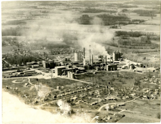
Cementville is an unincorporated community in Jeffersonville Township, Clark County, Indiana.

<span class="mw-page-title-main">Hamburg, Clark County, Indiana</span> Unincorporated community in Indiana, United States

Hamburg is an unincorporated community in Silver Creek Township, Clark County, Indiana. Parts of Hamburg are within the municipal boundaries of Clarksville and Sellersburg.

<span class="mw-page-title-main">Hibernia, Clark County, Indiana</span> Unincorporated community in Indiana, United States

Hibernia is an unincorporated community in Owen Township, Clark County, Indiana.

<span class="mw-page-title-main">Otisco, Indiana</span> Unincorporated community in Indiana, United States

Otisco is an unincorporated community in Charlestown Township, Clark County, Indiana.

<span class="mw-page-title-main">Otto, Indiana</span> Unincorporated community in Indiana, United States

Otto is an unincorporated community in Bethlehem Township, Clark County, Indiana.

<span class="mw-page-title-main">Owen, Indiana</span> Unincorporated community in Indiana, United States

Owen is an unincorporated community in Owen Township, Clark County, Indiana.

<span class="mw-page-title-main">Speed, Indiana</span> Unincorporated community in Indiana, United States

Speed is an unincorporated community in Silver Creek Township, Clark County, Indiana, United States. It used to be known as Fredricksburg.

Harris City is an unincorporated community in Sand Creek Township, Decatur County, Indiana.

Klemmes Corner is an unincorporated community in Highland Township, Franklin County, Indiana.

Old Bath is an unincorporated community in Bath Township, Franklin County, Indiana.

<span class="mw-page-title-main">Deputy, Indiana</span> Census-designated place in Indiana, United States

Deputy is a mid unincorporated community and census-designated place (CDP) in Graham Township, Jefferson County, Indiana, United States. By road it is approximately 18 miles (29 km) northwest of Madison, the county seat. As of the 2010 census it had a population of 86.

Kent is an unincorporated community and census-designated place (CDP) in Republican Township, Jefferson County, Indiana, United States. As of the 2010 census it had a population of 70.

Belleview is an unincorporated community in Monroe Township, Jefferson County, Indiana.

Middlefork is an unincorporated community in Lancaster Township, Jefferson County, Indiana.

Murdock is an unincorporated community in Lawrence County, Indiana, United States. It was originally developed around a rail yard.

References

  1. "U.S. Census website". United States Census Bureau . Retrieved January 31, 2008.
  2. "Blue Lick, Indiana". Geographic Names Information System . United States Geological Survey, United States Department of the Interior . Retrieved October 10, 2009.
  3. "Clark County". Jim Forte Postal History. Retrieved August 30, 2014.
  4. Baker, Ronald L. (October 1995). From Needmore to Prosperity: Hoosier Place Names in Folklore and History . Indiana University Press. p.  70. ISBN   978-0-253-32866-3. ...named for nearby Blue Lick Creek...
  5. Biographical and Historical Souvenir for the Counties of Clark, Crawford, Harrison, Floyd, Jefferson, Jennings, Scott, and Washington, Indiana. Chicago printing Company. 1889. p.  18.