
Jefferson County is located in the north central portion of the U.S. state of Kentucky. As of the 2020 census, the population was 782,969. It is the most populous county in the commonwealth.

Washington County is a county in the U.S. state of Indiana. As of the 2020 United States Census, the population was 28,182. The county seat is Salem.

Knox County is a county in the U.S. state of Indiana in the United States. The oldest county in Indiana, it was one of two original counties created in the Northwest Territory in 1790, alongside St. Clair County, Illinois. Knox County was gradually reduced in size as subsequent counties were established. It was established in its present configuration when Daviess County was partitioned off. At the 2020 United States Census, the county population was 36,282. The county seat is Vincennes.

Clark County is a county in the U.S. state of Indiana, located directly across the Ohio River from Louisville, Kentucky. At the 2020 census, the population was 121,093. The county seat is Jeffersonville. Clark County is part of the Louisville/Jefferson County, KY–IN Metropolitan Statistical Area.

The Louisville metropolitan area is the 43rd largest metropolitan statistical area (MSA) in the United States. It had a population of 1,395,855 in 2020 according to the latest official census, and its principal city is Louisville, Kentucky.

The geography of Indiana comprises the physical features of the land and relative location of U.S. State of Indiana. Indiana is in the north-central United States and borders on Lake Michigan. Surrounding states are Michigan to the north and northeast, Illinois to the west, Kentucky to the south, and Ohio to the east. The entire southern boundary is the Ohio River.

Clark Township is one of eleven townships in Montgomery County, Indiana, United States. As of the 2020 census, its population was 1,841 and it contained 766 housing units.

Clay Township is one of nine townships in Spencer County, Indiana. As of the 2020 census, its population was 2,862 and it contained 1,216 housing units.

Clark Township is one of nine townships in Johnson County, Indiana. As of the 2010 census, its population was 2,460 and it contained 863 housing units.
Lafayette Township is one of five townships in Floyd County, Indiana. As of the 2010 census, its population was 7,449 and it contained 2,856 housing units, although it remains one of the two townships in the county without an incorporated community, along with Franklin Township.

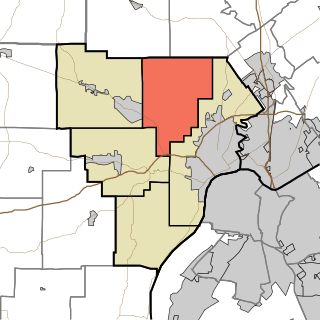
Carr Township is one of twelve townships in Clark County, Indiana. As of the 2020 census, its population was 4,830 and it contained 1,794 housing units.

Charlestown Township is one of twelve townships in Clark County, Indiana. As of the 2010 census, its population was 13,450 and it contained 5,382 housing units.

Oregon Township is one of twelve townships in Clark County, Indiana. As of the 2010 census, its population was 1,769 and it contained 692 housing units.
Utica Township is one of twelve townships in Clark County, Indiana. As of the 2010 census, its population was 6,016 and it contained 2,422 housing units.
Washington Township is one of twelve townships in Clark County, Indiana. As of the 2010 census, its population was 1,702 and it contained 744 housing units.

Wood Township is one of twelve townships in Clark County, Indiana. As of the 2010 census, its population was 2,747 and it contained 1,148 housing units.

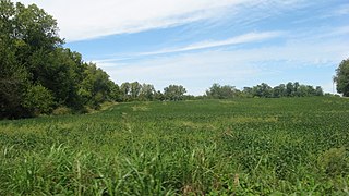
Broom Hill is an unincorporated community in Carr Township, Clark County, Indiana.
Pilot Knob is an unincorporated community in Jennings Township, Crawford County, Indiana.

Rolling Prairie is an unincorporated community and census-designated place (CDP) in Kankakee Township, LaPorte County, Indiana, United States. As of the 2020 census, it had a population of 562.


