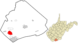
Mercer County is a county in Southern West Virginia on the southeastern border of the U.S. state of West Virginia. At the 2020 census, the population was 59,664. Its county seat is Princeton. The county was originally established in the State of Virginia by act of its General Assembly on March 17, 1837, using lands taken from Giles and Tazewell counties.

Amherst is a town in Amherst County, Virginia, United States. The population was 2,231 at the 2010 census. It is the county seat of Amherst County.

Bluefield is a town in Tazewell County, Virginia, United States, located along the Bluestone River. The population was 5,096 at the 2020 census. It is part of the Bluefield WV-VA micropolitan area which has a population of 106,363 in 2020.

Pocahontas is a town in Tazewell County, Virginia, United States. It was named for Chief Powhatan's daughter, Pocahontas, who lived in the 17th-century Jamestown Settlement. The town was founded as a company mining town by the Southwest Virginia Improvement Company in 1881. It was the first company mining town in Virginia. The post office opened on June 30, 1882.

Bolivar is a town in Jefferson County, West Virginia, United States. The population was 1,072 at the 2020 census. The town is named for South American revolutionary leader Simón Bolívar. Located in West Virginia's Eastern Panhandle, it is part of the northwestern fringes of the Washington metropolitan area.

Athens is a town in Mercer County, West Virginia, United States. The population was 944 at the 2020 census. It is part of the Bluefield, WV-VA micropolitan area which has a population of 107,578. Athens is the home of Concord University.

Bluefield is a city in Mercer County, West Virginia, United States. The population was 9,658 at the 2020 census. It is the principal city of the Bluefield micropolitan area extending into Virginia, which had a population of 106,363 in 2020.

Bramwell is a town in Mercer County, West Virginia, United States, along the Bluestone River. The population was 277 at the 2020 census. It is part of the Bluefield, WV-VA micropolitan area which has a population of 107,578.

Matoaka is a census-designated place in Mercer County, West Virginia, United States. The population was 173 at the 2020 census. It is part of the Bluefield, WV-VA micropolitan area which has a population of 100,093. This town is named for Chief Powhatan's daughter Matoaka who was better known by her nickname "Pocahontas". Matoaka became an unincorporated town when it voted to dissolve its charter in May 2018.

Oakvale is a town in Mercer County, West Virginia, United States, along the East River. The population was 137 at the 2020 census. It is part of the Bluefield, WV-VA micropolitan area which has a population of 107,578.

Tazewell County is a county located in the southwestern portion of the U.S. state of Virginia. As of the 2020 census, the population was 40,429. Its county seat is Tazewell.

U.S. Route 19 (US 19) is a part of the United States Numbered Highway System that runs from Memphis, Florida, to Erie, Pennsylvania. In Virginia, the highway runs 88.89 miles (143.05 km) between two pairs of twin cities: Bristol, Tennessee, and Bristol, Virginia, at the Virginia–Tennessee state line, and Bluefield, Virginia, and Bluefield, West Virginia, at the Virginia–West Virginia state line. Between its endpoints, US 19 has lengthy concurrencies with US 11, US 58 Alternate, and US 460 during its course connecting Abingdon, Lebanon, and Tazewell within Washington, Russell, and Tazewell counties in Southwest Virginia.
The Bluefield Micropolitan Statistical Area, as defined by the United States Census Bureau, is an area consisting of two counties – one in West Virginia and one in Virginia – anchored by the town of Bluefield, West Virginia.
Galloway is a census-designated place (CDP) and coal town in northwestern Barbour County, West Virginia, United States. It lies along West Virginia Route 76 northwest of the city of Philippi, the county seat of Barbour County. Its elevation is 1,073 feet (327 m). It has a post office with the ZIP code 26349. As of the 2010 census, its population is 143.
Belva is an unincorporated community and census-designated place in west Nicholas County and north Fayette County, West Virginia, United States; while the CDP only includes the Nicholas County portion, the Fayette County portion is considered part of the community. The town is situated at the bottomland surrounding the convergence of Bells Creek with Twentymile Creek and, subsequently, Twenty Mile Creek with the Gauley River. Belva is also the location of the convergence of two state highways: West Virginia Route 16 and West Virginia Route 39.
Hico is a census-designated place (CDP) in Fayette County, West Virginia, United States. Hico is located at the junction of U.S. routes 19 and 60, 7 miles (11 km) northeast of Fayetteville. Hico has a post office with ZIP code 25854. As of the 2010 census, its population was 272.
Hilltop is a census-designated place (CDP) in Fayette County, West Virginia, United States. Hilltop is located on state routes 16 and 61, 2 miles (3.2 km) south of Oak Hill. Hilltop has a post office with ZIP code 25855. As of the 2010 census, its population was 624.
Dixie is a census-designated place (CDP) in Fayette and Nicholas counties, West Virginia, United States. Dixie is located on West Virginia Route 16, 5.5 miles (8.9 km) north of Gauley Bridge. Dixie has a post office with ZIP code 25059. As of the 2010 census, its population was 291, with 202 residents in Nicholas County and 89 in Fayette County.
Big Creek is a census-designated place (CDP) in Logan County, West Virginia, United States. Big Creek is located on West Virginia Route 10, 2.5 miles (4.0 km) northwest of Chapmanville. Big Creek has a post office with ZIP code 25505. As of the 2010 census, its population was 237.

Brush Fork is a census-designated place (CDP) in Mercer County, West Virginia, United States. Brush Fork is 2 miles (3.2 km) northwest of Bluefield. As of the 2010 census, its population was 1,197.