Mercer County is a county in Southern West Virginia on the southeastern border of the U.S. state of West Virginia. At the 2020 census, the population was 59,664. Its county seat is Princeton. The county was originally established in the State of Virginia by act of its General Assembly on March 17, 1837, using lands taken from Giles and Tazewell counties.
Pentress is a census-designated place (CDP) in northern Monongalia County, West Virginia, United States. It lies along West Virginia Route 7 northwest of the city of Morgantown, the county seat of Monongalia County. Its elevation is 951 feet (290 m). "Pentress" is not the only name the community has had; at various times in its history, it has been known as Minors Mills, New Brownsville, Pentrees, Pentress Junction, Statler Town, Statlers Town, Statlersville, and Stradlerstown. The present name of Pentress was selected by an early settler who reportedly wanted a Welsh name. It has a post office with the ZIP Code of 26544. As of the 2010 census, its population was 175.
Galloway is a census-designated place (CDP) and coal town in northwestern Barbour County, West Virginia, United States. It lies along West Virginia Route 76 northwest of the city of Philippi, the county seat of Barbour County. Its elevation is 1,073 feet (327 m). It has a post office with the ZIP code 26349. As of the 2010 census, its population is 143.

Salt Rock is a census-designated place (CDP) in southern Cabell County, West Virginia, United States. As of the 2010 census, its population was 388. It lies along West Virginia Route 10 southeast of the city of Huntington, the county seat of Cabell County. Its elevation is 581 feet (177 m). Although Salt Rock is unincorporated, it has a post office, with the ZIP code of 25559. The community most likely was so named on account of there being a small-scale local salt manufacturing industry.
Justice is a census-designated place in Mingo County, West Virginia, United States. Justice is located on U.S. Route 52, 2.5 miles (4.0 km) southeast of Gilbert. Justice has a post office with ZIP code 24851. As of the 2010 census, its population was 412.
Raysal is a census-designated place (CDP) in McDowell County, West Virginia, United States. Raysal is located along West Virginia Route 83, 1 mile (1.6 km) southeast of Bradshaw. Raysal has a post office with ZIP code 24879. As of the 2010 census, its population was 465.

Roderfield is a census-designated place (CDP) in McDowell County, West Virginia, United States. Roderfield is 7 miles (11 km) west-northwest of Welch. Roderfield has a post office with ZIP code 24881. As of the 2010 census, its population is 188.
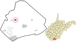
Carolina is a census-designated place (CDP) in Marion County, West Virginia, United States. Carolina is 2 miles (3.2 km) north-northwest of Worthington. Carolina has a post office with ZIP code 26563. As of the 2010 census, its population was 411.

Bolt is a census-designated place (CDP) in Raleigh County, West Virginia, United States. Bolt is located on West Virginia Route 99, 12 miles (19 km) west of Beckley. Bolt has a post office with ZIP code 25817. As of the 2010 census, its population is 548.
Hico is a census-designated place (CDP) in Fayette County, West Virginia, United States. Hico is located at the junction of U.S. routes 19 and 60, 7 miles (11 km) northeast of Fayetteville. Hico has a post office with ZIP code 25854. As of the 2010 census, its population was 272.

Mount Carbon is a census-designated place (CDP) in Fayette County, West Virginia, United States. Mount Carbon is located along West Virginia Route 61, 3 miles (4.8 km) southeast of Montgomery, on the south bank of the Kanawha River at the mouth of Armstrong Creek. Mount Carbon has a post office with ZIP code 25139. As of the 2010 census, its population was 428.

Scarbro is a census-designated place (CDP) and coal town in Fayette County, West Virginia, United States. Scarbro is 1.5 miles (2.4 km) southwest of Oak Hill. Scarbro has a post office with ZIP code 25917. As of the 2010 census, its population was 486.
Eccles is a census-designated place (CDP) in Raleigh County, West Virginia, United States. Eccles is located on West Virginia Route 3, 4 miles (6.4 km) west of Beckley. Eccles has a post office with ZIP code 25836. As of the 2010 census, its population is 362.
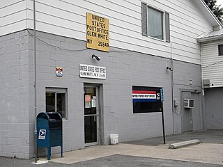
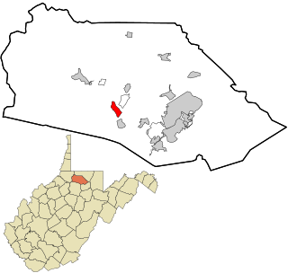
Glen White is a census-designated place (CDP) in Raleigh County, West Virginia, United States. Glen White is located on state routes 54 and 97, 1 mile (1.6 km) southeast of Lester. Glen White had a post office with ZIP code 25849. As of the 2010 census, its population is 266.
Spelter is a census-designated place (CDP) in Harrison County, West Virginia, United States. Spelter is 4.5 miles (7.2 km) north of Clarksburg. Spelter has a post office with ZIP code 26438. As of the 2010 census, its population was 346.
Dixie is a census-designated place (CDP) in Fayette and Nicholas counties, West Virginia, United States. Dixie is located on West Virginia Route 16, 5.5 miles (8.9 km) north of Gauley Bridge. Dixie has a post office with ZIP code 25059. As of the 2010 census, its population was 291, with 202 residents in Nicholas County and 89 in Fayette County.
Big Creek is a census-designated place (CDP) in Logan County, West Virginia, United States. Big Creek is located on West Virginia Route 10, 2.5 miles (4.0 km) northwest of Chapmanville. Big Creek has a post office with ZIP code 25505. As of the 2010 census, its population was 237.
Bruno is a census-designated place (CDP) in Logan County, West Virginia, United States. Bruno is located on the west bank of the Guyandotte River, 3.5 miles (5.6 km) south of Man. Bruno has a post office with ZIP code 25611. As of the 2010 census, its population was 544.
Chauncey is a census-designated place (CDP) in Logan County, West Virginia, United States. Chauncey is located along West Virginia Route 44 and Island Creek, 5.5 miles (8.9 km) south of Logan. Chauncey had a post office, which opened on August 23, 1913, and closed on June 27, 2009. As of the 2010 census, its population is 283.
Valley Bend is a census-designated place (CDP) in Randolph County, West Virginia, United States. Valley Bend is located on U.S. routes 219 and 250, as well as state routes 55 and 92, 3.5 miles (5.6 km) northwest of Mill Creek. Valley Bend has a post office with ZIP code 26293. As of the 2010 census, its population was 485.