
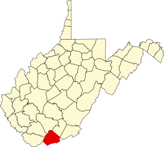
Mercer County is a county in Southern West Virginia on the southeastern border of the U.S. state of West Virginia. At the 2020 census, the population was 59,664. Its county seat is Princeton. The county was originally established in the State of Virginia by act of its General Assembly on March 17, 1837, using lands taken from Giles and Tazewell counties.
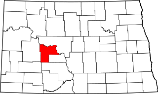
Mercer County is a county in the U.S. state of North Dakota. As of the 2020 census, the population was 8,350. Its county seat is Stanton.

Mercer County is a county located in the central part of the U.S. Commonwealth of Kentucky. As of the 2020 census, the population was 23,772. Its county seat is Harrodsburg. The county was formed from Lincoln County, Virginia in 1785 and is named for Revolutionary War General Hugh Mercer, who was killed at the Battle of Princeton in 1777. It was formerly a prohibition or dry county.

West Virginia's 3rd congressional district is an obsolete U.S. congressional district in southern West Virginia. At various times the district covered different parts of the state, but in its final form included the state's second-largest city, Huntington; included Bluefield, Princeton, and Beckley; and has a long history of coal mining, forestry, and farming.

West Virginia's 1st congressional district is currently located in the southern half of the state.

West Virginia Route 71 is a north–south state highway located within Mercer County, West Virginia. The southern terminus of the route is at U.S. Route 52 in Bluewell, north of Bluefield. The northern terminus is at West Virginia Route 10 in Matoaka.

The Shawnee Parkway, planned to be designated as West Virginia Route 154, is a proposed 23-mile-long (37 km) two-lane arterial highway. Should it be constructed, the highway will run through McDowell, Wyoming, Mercer, and Raleigh counties in southwestern West Virginia. The expressway is proposed to begin at the Ghent interchange along Interstate 77 in the east and end at the planned King Coal Highway near Ashland.
Virginia's 17th congressional district is an obsolete congressional district. It was eliminated in 1843 after the 1840 U.S. census. Its last congressman was Alexander H. H. Stuart.

Tate Lohr Wildlife Management Area, is located in Mercer County near the community of Oakvale, West Virginia. Tate Lohr WMA is located on 500 acres (200 ha) of sloping terrain varying from 2,100 feet (640 m) to 3,500 feet (1,100 m).
This is a list of the National Register of Historic Places listings in Mercer County, West Virginia.
Mercers Saltworks is a former settlement in Summers County, West Virginia, United States. Mercers Saltworks was located on the New River, east of Lick Creek and appeared on maps as late as 1932.
Mercers Bottom is an unincorporated community in Mason County, West Virginia, United States. It is situated on the east bank of the Ohio River along West Virginia Route 2, some 13.5 miles (21.7 km) south of Point Pleasant.
Midway may refer to the following communities in the U.S. state of West Virginia:
Sandlick is an unincorporated community in Mercer County, West Virginia, United States. Sandlick is located on Sandlick Creek at the junction of County Routes 71/5 and 71/13, 4.8 miles (7.7 km) north of Bluefield.
New Hope is an unincorporated community in Mercer County, West Virginia, United States. New Hope is located on West Virginia Route 20, 4 miles (6.4 km) west-southwest of Princeton.
Crystal is an unincorporated community in Mercer County, West Virginia, United States. Crystal is located on Crane Creek and County Route 11, 7.6 miles (12.2 km) north-northwest of Bluefield.
Weyanoke is an unincorporated community in Mercer County, West Virginia, United States. Weyanoke is located on County Route 11, 1 mile (1.6 km) west of Matoaka.

U.S. Route 33 (US 33) is a United States Numbered Highway running from near Elkhart, Indiana, to Richmond, Virginia. Within the state of Ohio, it is a predominantly southeast–northwest highway running from west of Willshire before crossing over into West Virginia via the Ravenswood Bridge over the Ohio River. The route runs through largely rural territory throughout most of the state's west-central, central, and southeastern regions, although it also passes through large portions of downtown Columbus.
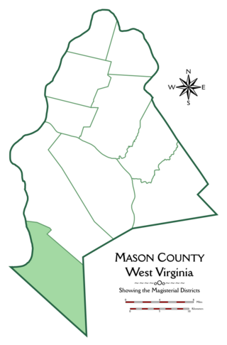
Hannan Magisterial District is one of ten magisterial districts in Mason County, West Virginia, United States. The district was originally established as a civil township in 1863, and converted into a magisterial district in 1872. In 2020, Clendenin District was home to 2,688 people.

West Virginia's 6th Senate district is one of 17 districts in the West Virginia Senate. It is currently represented by Republicans Mark Maynard and Chandler Swope. All districts in the West Virginia Senate elect two members to staggered four-year terms. District 6 is currently the most Republican-leaning district in the Senate.


