Botsford Parish, New Brunswick

Last updated

Botsford
Westmorland County NB - Botsford Parish.png
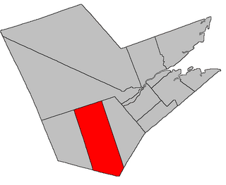
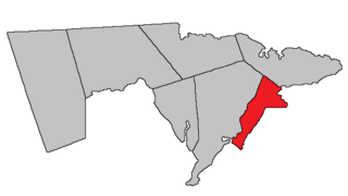
Location within Westmorland County, New Brunswick.
Coordinates: 46°11′N64°36′W / 46.19°N 64.60°W / 46.19; -64.60
Country Flag of Canada (Pantone).svg  Canada
Province Flag of New Brunswick.svg  New Brunswick
County Westmorland County
Erected1805
Area
[1]
  Land304.62 km2 (117.61 sq mi)
Population
 (2021) [1]
  Total1,120
  Density3.7/km2 (10/sq mi)
  Change 2016-2021
Increase2.svg 5.9%
  Dwellings
978
Time zone UTC-4 (AST)
  Summer (DST) UTC-3 (ADT)
Figures do not include portions within the villages of Cap-Pelé and Port Elgin and the rural community of Beaubassin East

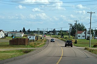
Botsford is a geographic parish in Westmorland County, New Brunswick, Canada. [4]

Contents

For governance purposes it divided almost entirely between the town of Cap-Acadie and the incorporated rural community of Strait Shores, [5] small areas along its southwestern border belong to the Southeast rural district. [lower-alpha 1] All are members of the Southeast Regional Service Commission. [6]

Prior to the 2023 governance reform, the parish was divided between the villages of Cap-Pelé and Port Elgin, [7] the rural community of Beaubassin East, [8] and the local service districts of Bayfield, Cape Tormentine, and the parish of Botsford. [9]

Origin of name

The parish was named in honour of Amos Botsford, then Speaker of the House of Assembly [10] and MLA for Westmorland County.

History

Botsford was erected in 1805 from all of the unassigned territory east of Sackville and Westmorland Parishes. [11]

In 1850 the western boundary moved west to match that of Westmorland Parish, adding part of Shediac Parish. [12] The western boundary was at the mouth of the Kouchibouguac River.

In 1894 the western boundary was altered on its northern end, the boundary with Shediac Parish now running through Cap-Pelé. [13] This was clarified in 1904. [14]

Boundaries

Botsford Parish is bounded: [2] [15] [16]

Communities

Communities at least partly within the parish. [15] [16] [20] bold indicates an incorporated municipality

Bodies of water

Bodies of water [lower-alpha 4] at least partly within the parish. [15] [16] [20]

Islands

Islands at least partly within the parish. [15] [16] [20]

Other notable places

Parks, historic sites, and other noteworthy places at least partly within the parish. [15] [16] [20]

Demographics

Parish population total does not include portions within 2021 boundaries of Cap-Pelé, Port Elgin, and Beaubassin East. Revised census figures based on the 2023 local governance reforms have not been released.

Historical populations:
Botsford Parish, NB
YearPop.±%
19911,328    
1996 1,297−2.3%
2001 1,216−6.2%
2006 1,203−1.1%
2011 1,074−10.7%
2016 1,058−1.5%
[22] [23] [24]

Access routes

Highways and numbered routes that run through the parish, including external routes that start or finish at the parish limits: [25]

See also

Notes

  1. Maps still visible as thumbnails show the current and previous governance boundaries. [5]
  2. By the magnet of 1867, [13] when declination in the area was between 21º and 22º west of north. [17]
  3. By the magnet of 1903, [14] when declination in the area was between 22º and 23º west of north. [18] The Territorial Division Act clause referring to magnetic direction bearings was omitted in the 1952 [19] and 1973 Revised Statutes. [2]
  4. Not including brooks, ponds or coves.

Related Research Articles

<span class="mw-page-title-main">Moncton Parish, New Brunswick</span> Parish in New Brunswick, Canada

Moncton is a geographic parish in Westmorland County, New Brunswick, Canada.

<span class="mw-page-title-main">Kingsclear Parish, New Brunswick</span> Parish in New Brunswick, Canada

Kingsclear is a geographic parish in York County, New Brunswick, Canada.

<span class="mw-page-title-main">Beaubassin East, New Brunswick</span> Place in New Brunswick, Canada

Beaubassin East was an incorporated rural community in Westmorland County, New Brunswick, Canada. It held rural community status prior to 2023 and is now part of the town of Cap-Acadie.

<span class="mw-page-title-main">Richibucto Parish, New Brunswick</span> Parish in New Brunswick, Canada

Richibucto is a geographic parish in Kent County, New Brunswick, Canada.

<span class="mw-page-title-main">Acadieville Parish, New Brunswick</span> Parish in New Brunswick, Canada

Acadieville is a geographic parish in Kent County, New Brunswick, Canada.

<span class="mw-page-title-main">Blissfield Parish, New Brunswick</span> Parish in New Brunswick, Canada

Blissfield is a geographic parish in Northumberland County, New Brunswick, Canada.

<span class="mw-page-title-main">Sackville Parish, New Brunswick</span> Parish in New Brunswick, Canada

Sackville is a geographic parish in Westmorland County, New Brunswick, Canada.

<span class="mw-page-title-main">Wellington Parish, New Brunswick</span> Parish in New Brunswick, Canada

Wellington is a geographic parish in Kent County, New Brunswick, Canada.

<span class="mw-page-title-main">Sainte-Marie Parish, New Brunswick</span> Parish in New Brunswick, Canada

Saint-Marie, is a geographic parish in Kent County, New Brunswick, Canada.

<span class="mw-page-title-main">Saint-Paul Parish, New Brunswick</span> Parish in New Brunswick, Canada

Saint-Paul is a geographic parish in Kent County, New Brunswick, Canada.

<span class="mw-page-title-main">Weldford Parish, New Brunswick</span> Parish in New Brunswick, Canada

Weldford is a geographic parish in Kent County, New Brunswick, Canada.

<span class="mw-page-title-main">Harcourt Parish, New Brunswick</span> Parish in New Brunswick, Canada

Harcourt is a geographic parish in Kent County, New Brunswick, Canada.

<span class="mw-page-title-main">Huskisson Parish, New Brunswick</span> Parish in New Brunswick, Canada

Huskisson is a geographic parish in Kent County, New Brunswick, Canada.

<span class="mw-page-title-main">Elgin Parish, New Brunswick</span> Parish in New Brunswick, Canada

Elgin is a geographic parish in the interior of Albert County, New Brunswick, Canada, the only one of the county's parishes that does not border either the Bay of Fundy or the Petitcodiac River.

<span class="mw-page-title-main">Hopewell Parish, New Brunswick</span> Parish in New Brunswick, Canada

Hopewell is a geographic parish in eastern Albert County, New Brunswick, Canada.

<span class="mw-page-title-main">Harvey Parish, New Brunswick</span> Parish in New Brunswick, Canada

Harvey is a geographic parish in southern Albert County, New Brunswick, Canada.

<span class="mw-page-title-main">Shediac Parish, New Brunswick</span> Parish in New Brunswick, Canada

Shediac is a geographic parish in Westmorland County, New Brunswick, Canada.

<span class="mw-page-title-main">Westmorland Parish, New Brunswick</span> Parish in New Brunswick, Canada

Westmorland is a geographic parish in Westmorland County, New Brunswick, Canada.

<span class="mw-page-title-main">Dorchester Parish, New Brunswick</span> Parish in New Brunswick, Canada

Dorchester is a geographic parish in Westmorland County, New Brunswick, Canada.

<span class="mw-page-title-main">Brunswick Parish, New Brunswick</span> Parish in New Brunswick, Canada

Brunswick is a geographic parish in the northeastern corner of Queens County, New Brunswick, Canada.

References

  1. 1 2 "Census Profile". Statistics Canada. 26 October 2022. Retrieved 29 October 2022.
  2. 1 2 3 "Chapter T-3 Territorial Division Act". Government of New Brunswick. Retrieved 26 March 2023.
  3. "Chapter I-13 Interpretation Act". Government of New Brunswick. Retrieved 26 March 2023.
  4. The Territorial Division Act [2] divides the province into 152 parishes, the cities of Saint John and Fredericton, and one town of Grand Falls. The Interpretation Act [3] clarifies that parishes include any local government within their borders.
  5. 1 2 "Southeast Regional Service Commission: RSC 7". Government of New Brunswick. Retrieved 26 March 2023.
  6. "Regions Regulation – Regional Service Delivery Act". Government of New Brunswick. 21 July 2022. Retrieved 26 March 2023.
  7. "Municipalities Order - Municipalities Act". Government of New Brunswick. 25 June 2021. Retrieved 26 March 2023.
  8. "New Brunswick Regulation 95-36 under the Municipalities Act (O.C. 95-342)". Government of New Brunswick. Retrieved 23 July 2020.
  9. "Local Service Districts Regulation - Municipalities Act". Government of New Brunswick. 25 June 2021. Retrieved 26 March 2023.
  10. Ganong, William F. (1896). A Monograph of the Place-Nomenclature of the Province of New Brunswick. Royal Society of Canada. p. 222. Retrieved 17 March 2021.
  11. "45 Geo. III c. 18 An Act for erecting the Eastern part of the county of Westmorland into a distinct Town or Parish.". Acts of the General Assembly, of His Majesty's Province of New-Brunswick, Passed in the Year 1805. Saint John, New Brunswick: Government of New Brunswick. 1805. pp. 368–369. Retrieved 27 March 2021.
  12. "13 Vic. c. 51 An Act to consolidate all the Laws now in force for the division of the Province into Counties, Towns and Parishes.". Acts of the General Assembly of Her Mjaesty's Province of New Brunswick, Passed in the Year 1850. Fredericton: Government of New Brunswick. 1850. pp. 142–152, 145–149. Retrieved 27 March 2021. Book was poorly proofread, resulting in title typo and reuse of page numbers 145–152.
  13. 1 2 "57 Vic. c. 36 An Act to amend Chapter 2 of the Consolidated Statutes, of 'The division of the Province into Counties, Towns and Parishes,' so far as relates to the County of Westmorland.". Acts of the General Assembly of Her Majesty's Province of New Brunswick. Passed in the Month of April, 1894. Fredericton: Government of New Brunswick. 1894. pp. 162–163. Available as a free ebook from Google Books.
  14. 1 2 "4 Edward 7 c. 13 An Act in amendment of the Act 59 Victoria, Chapter 8, intituled 'An Act to revise and codify An Act to provide for the division of the Province into Counties, Towns and Parishes.'". Acts of the Legislative Assembly of His Majesty's Province of New Brunswick. Passed in the Month of April, 1904. Fredericton: Government of New Brunswick. 1904. pp. 77–78.
  15. 1 2 3 4 5 "No. 121". Provincial Archives of New Brunswick. Department of Natural Resources and Energy Development. Retrieved 24 June 2021. Remainder of parish on map 122 at same site.
  16. 1 2 3 4 5 "321" (PDF). Transportation and Infrastructure. Government of New Brunswick. Retrieved 24 June 2021. Remainder of parish on mapbooks 322, 340–343, and 362–364 at same site.
  17. "Historical Magnetic Declination". National Oceanic and Atmospheric Administration. Retrieved 2 May 2021.
  18. "Historical Magnetic Declination". National Oceanic and Atmospheric Administration. Retrieved 2 May 2021.
  19. "Chapter 227 Territorial Division Act". The Revised Statutes of New Brunswick 1952 Volume III. Fredericton: Government of New Brunswick. 1952. pp. 3725–3771.
  20. 1 2 3 4 "Search the Canadian Geographical Names Database (CGNDB)". Government of Canada. Retrieved 5 July 2021.
  21. "New Brunswick Regulation 2017-46 under the Parks Act (O.C. 2017-293)" (PDF). The Royal Gazette. 175. Fredericton: Queen's Printer: 1496–1497. 13 December 2017. ISSN   1714-9428 . Retrieved 5 July 2021.
  22. Statistics Canada: 2001, 2006 census
  23. 2011 Statistics Canada Census Profile: Botsford Parish, New Brunswick
  24. "Census Profile, 2016 Census: Botsford, Parish [Census subdivision], New Brunswick". Statistics Canada. Retrieved 5 October 2019.
  25. Atlantic Canada Back Road Atlas ISBN   978-1-55368-618-7


46°06′41″N63°58′32″W / 46.111326°N 63.975449°W / 46.111326; -63.975449 (Botsford Parish, New Brunswick)