Westmorland | |
---|---|
Coordinates: 46°04′N64°31′W / 46.06°N 64.51°W | |
Country | Canada |
Province | New Brunswick |
Established | 1785 |
Area | |
• Land | 3,666.15 km2 (1,415.51 sq mi) |
Population (2021) [2] | |
• Total | 163,576 |
• Density | 44.7/km2 (116/sq mi) |
• Change 2016-2021 | 9.3% |
• Dwellings | 75,506 |
Time zone | UTC-4 (AST) |
• Summer (DST) | UTC-3 (ADT) |
Area code | 506 |
Westmorland County (2021 population: 163,576 [2] ) is a county in New Brunswick, a province of Canada. It is in the south-eastern part of the province. It contains the fast-growing commercial centre of Moncton and its northern and eastern suburbs. Also located in the county are the university town of Sackville and the local tourist destination of Shediac.
Westmorland County is centrally located in the Maritimes and is New Brunswick's most populous county. Fishing and tourism are important industries along the Northumberland Strait shore, and there is some mixed farming in the Petitcodiac River Valley and in the Tantramar Marsh region. The city of Moncton accounts for half of the county's population and has developed as a major transportation, distribution, commercial and retail centre. Dorchester is the historic shire town.
The county, once a part of Cumberland County, Nova Scotia, was one of the original eight counties delineated shortly after the creation of the British colony of New Brunswick in 1784. Initially it included what is now Albert County and part of Saint John County.
Due to sweeping social reforms of the Louis Robichaud premiership, the counties no longer serve their role as regional local government and administrative units.
There are the eleven municipalities within Westmorland County (listed by 2016 population): [3]
Official Name | Designation | Area km2 | Population | Parish |
---|---|---|---|---|
Moncton | City | 141.92 | 71,889 | Moncton |
Dieppe | City | 54.05 | 25,384 | Moncton |
Beaubassin East | Rural community | 291.08 | 6,376 | Shediac |
Shediac | Town | 53.95 | 6,664 | Shediac |
Sackville | Town | 74.17 | 5,331 | Sackville |
Memramcook | Village | 187.67 | 4,778 | Dorchester |
Cap-Pelé | Village | 23.36 | 2,425 | Botsford |
Salisbury | Village | 13.54 | 2,284 | Salisbury |
Petitcodiac | Village | 17.21 | 1,383 | Salisbury |
Dorchester | Village | 5.79 | 1,096 | Dorchester |
Strait Shores | Rural community | 2.66 | 408 | Westmorland |
There is one First Nations reserve in Westmorland County (population as of 2016): [4]
Official Name | Designation | Area km2 | Population | Parish |
---|---|---|---|---|
Fort Folly 1 | Reserve | 0.55 | 48 | Dorchester |
The county is subdivided into seven parishes (listed by 2016 population): [3]
Year | Pop. | ±% |
---|---|---|
1991 | 114,745 | — |
1996 | 120,531 | +5.0% |
2001 | 124,688 | +3.4% |
2006 | 132,849 | +6.5% |
2011 | 144,158 | +8.5% |
2016 | 149,623 | +3.8% |
2021 | 163,576 | +9.3% |
[5] [6] [1] [2] |
As a census division in the 2021 Census of Population conducted by Statistics Canada, Westmorland County had a population of 163,576 living in 70,090 of its 75,506 total private dwellings, a change of 9.3% from its 2016 population of 149,623. With a land area of 3,659.74 km2 (1,413.03 sq mi), it had a population density of 44.7/km2 (115.8/sq mi) in 2021. [2]
2016 | 2011 | |
---|---|---|
Population | 149,623 (+3.8% from 2011) | 144,158 (+8.5% from 2006) |
Land area | 3,666.15 km2 (1,415.51 sq mi) | 3,662.02 km2 (1,413.91 sq mi) |
Population density | 40.8/km2 (106/sq mi) | 39.4/km2 (102/sq mi) |
Median age | 43.1 (M: 42.2, F: 43.9) | 41.4 (M: 40.5, F: 42.4) |
Private dwellings | 71,839 (total) | 67,842 (total) |
Median household income | $61,903 | $55,736 |
Canada Census Mother Tongue - Westmorland County, New Brunswick [5] [6] [1] | ||||||||||||||||||
---|---|---|---|---|---|---|---|---|---|---|---|---|---|---|---|---|---|---|
Census | Total | English | French | French & English | Non-official languages | |||||||||||||
Year | Responses | Count | Trend | Pop % | Count | Trend | Pop % | Count | Trend | Pop % | Count | Trend | Pop % | |||||
2016 | 146,610 | 77,450 | 1.3% | 52.83% | 60,570 | 3.0% | 41.31% | 2,430 | 13.0% | 1.66% | 6,160 | 74.0% | 4.20% | |||||
2011 | 140,925 | 76,475 | 7.8% | 54.27% | 58,795 | 7.2% | 41.72% | 2,115 | 67.2% | 1.50% | 3,540 | 17.6% | 2.51% | |||||
2006 | 130,080 | 70,945 | 3.6% | 54.54% | 54,860 | 7.4% | 42.17% | 1,265 | 6.3% | 0.97% | 3,010 | 102.7% | 2.31% | |||||
2001 | 122,405 | 68,510 | 1.2% | 55.97% | 51,060 | 6.7% | 41.71% | 1,350 | 7.2% | 1.10% | 1,485 | 12.9% | 1.21% | |||||
1996 | 118,330 | 67,700 | n/a | 57.21% | 47,860 | n/a | 40.45% | 1,455 | n/a | 1.23% | 1,315 | n/a | 1.11% |
Highways and numbered routes that run through the county, including external routes that start or finish at the county limits: [10]
|
|
Cumberland County is a county in the Canadian province of Nova Scotia.
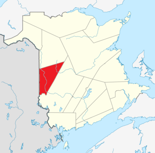
Albert County is New Brunswick's third-youngest county located on the Western side of the Petitcodiac River on the Chignecto Bay in the Bay of Fundy. Prior to the abolition of county government in 1967, the shire town was Hopewell Cape. The county was established in 1845 from parts of Westmorland County and Saint John County, and named after Prince Albert.
Carleton County is located in west-central New Brunswick, Canada.
Charlotte County is the southwest-most county of New Brunswick, Canada.
Gloucester County is located in the northeastern corner of New Brunswick, Canada. Fishing, mining and forestry are the major industries in the county. The eastern section of the county is known for its Acadian culture. The county is named for Princess Mary, Duchess of Gloucester and Edinburgh.
Kent County is located in east-central New Brunswick, Canada. The county features a unique blend of cultures including Mi'kmaq, Acadian, and English. Some larger tourist attractions include the dune de Bouctouche, Kouchibouguac National Park, and Bonar Law Commons.
Madawaska County, also known as the "New Brunswick Panhandle", is located in northwestern New Brunswick, Canada. Over 90% of the county's population speaks French. Its Francophone population are known as "Brayons." Forestry is the major industry in the county.
Northumberland County is located in northeastern New Brunswick, Canada.
Queens County is located in central New Brunswick, Canada. The county shire town is the village of Gagetown. The county was named as an expression of loyalty to the Crown and to commemorate a group of earlier settlers originally from Queens County, New York.
Restigouche County is located in north-central New Brunswick, Canada. The county is named for the Restigouche River which flows through the county and is famous for its salmon pools, which have attracted wealthy American and Canadian tourists to the region's summer colonies for decades. Forestry dominates the local economy.
Saint John County is located in southern New Brunswick, Canada. The city of Saint John dominates the county. Elsewhere in the county, tourism is focused around the Bay of Fundy.
Sunbury County is located in central New Brunswick, Canada. A large military base is located in the western part of the county south of the town of Oromocto. The county also hosts forestry and mixed farming. Burton is the county shire town.
Victoria County is located in northwestern New Brunswick, Canada. Farming, especially of potatoes, is the major industry in the county. The area was named for Queen Victoria.
York County is located in west-central New Brunswick, Canada. The county contains the provincial capital, Fredericton. Outside the city, farming and forestry are two major industries in the county, which is bisected by the Saint John River. The Southwest Miramichi River flows through the northern section of the county.
Queens County is a county in the province of Prince Edward Island, Canada. It is the largest county in the province by population with 89,770 (2021) and land. Charlottetown is the county seat of Queens County, and is the largest city and the capital of Prince Edward Island.
Salisbury is a town located in Westmorland County, New Brunswick, Canada.
Beaubassin East was an incorporated rural community in Westmorland County, New Brunswick, Canada. It held rural community status prior to 2023 and is now part of the town of Cap-Acadie.
Cap-Pelé is a former village in Westmorland County, New Brunswick, Canada. It held village status prior to 2023 and is now part of the town of Cap-Acadie.
Petitcodiac is a former village in Westmorland County, New Brunswick, Canada. It held village status prior to 2023 and is now part of the village of Three Rivers.
Prince County is located in western Prince Edward Island, Canada. The county's defining geographic feature is Malpeque Bay, a sub-basin of the Gulf of St. Lawrence, which creates the narrowest portion of Prince Edward Island's landmass, an isthmus upon which the city of Summerside is located.