Fort Miles was a United States Army World War II installation located on Cape Henlopen near Lewes, Delaware. Although funds to build the fort were approved in 1934, it was 1938 before construction began on the fort. On 3 June 1941 it was named for Lieutenant General Nelson A. Miles.

Fort Tilden, also known as Fort Tilden Historic District, is a former United States Army installation on the coast in the New York City borough of Queens. Fort Tilden now forms part of the Gateway National Recreation Area, and is administered by the National Park Service.

Fort Taber District or the Fort at Clark's Point is a historic American Civil War-era military fort on Wharf Road within the former Fort Rodman Military Reservation in New Bedford, Massachusetts. The fort is now part of Fort Taber Park, a 47-acre town park located at Clark's Point. Fort Taber was an earthwork built nearby with city resources and garrisoned 1861-1863 until Fort Rodman was ready for service.

Odiorne Point State Park is a public recreation area located on the Atlantic seacoast in the town of Rye near Portsmouth, New Hampshire. Among the park's features are the Seacoast Science Center and the remains of the World War II Fort Dearborn. The park offers opportunities for hiking, cycling, picnicking, fishing, and boating.

Barneys Joy Point Military Reservation was a World War II coastal defense site located in Dartmouth, Massachusetts.
Calf Island Military Reservation was a World War II coastal defense site located on Calf Island in Hull, Massachusetts.
East Point Military Reservation was a World War I and World War II coastal defense site located in Nahant, Massachusetts. In 1955–62 it was a Nike missile launch site. In 1967 the site was converted into the Marine Science Center of Northeastern University.
Elizabeth Islands Military Reservation was a World War II coastal defense site located on Cuttyhunk Island and Nashawena Island in the town of Gosnold, Massachusetts.

Mishaum Point Military Reservation was a coastal defense site located in Dartmouth, Massachusetts as part of the Harbor Defenses of New Bedford.

Salisbury Beach Military Reservation was a coastal defense site located in Salisbury, Massachusetts.
Jewell Island is a small island in Casco Bay, Maine, United States. Approximately 1 mile (1.6 km) long from southwest to northeast, it is located off the coast of Cliff Island, approximately eight miles from downtown Portland. It is a state-owned island with a small but protected harbor as well as camping and walking paths. Jewell Island was part of the Harbor Defenses of Portland fort network. The island is part of the city of Portland. Jewell Island can be reached by private or charter boats. There is no ferry service to the island.

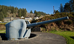
Fort Duvall was a Coast Artillery fort, part of the Harbor Defenses of Boston, in Massachusetts. What was then called Hog Island in Hull, Massachusetts was acquired by the U.S. government in 1917, and the fort was constructed in the early 1920s. It had only one gun battery, Battery Long, but it mounted the largest caliber weapons in the entire harbor defense system: a pair of 16-inch guns. These were the 16-inch gun M1919, of which only seven were deployed; 16-inch weapons deployed later were supplied by the Navy.
Fort Dawes was a World War II Coast Artillery fort located on Deer Island in Winthrop/Boston, Massachusetts. It was part of the Harbor Defenses of Boston.

Battery Steele is a United States military fortification on Peaks Island, Portland, Maine in Casco Bay. Completed in 1942 as part of World War II, it is located on 14 acres (5.7 ha) on the oceanside area of the island, formerly part of the Peaks Island Military Reservation. It is named for Harry L. Steele, who was a Coast Artillery officer during World War I. It was armed with two 16-inch MkIIMI guns and, with a 12-inch gun battery at Fort Levett on Cushing Island, replaced all previous heavy guns in the Harbor Defenses of Portland. It was built to protect Casco Bay, particularly Portland harbor, from Kennebunk to Popham Beach in Phippsburg. According to Kim MacIsaac and historian Joel Eastman in An Island at War, “Battery Steele is not only the largest gun battery built on Peaks Island, but also an example of the largest battery ever built anywhere in the United States.” In 1995, after decades of non-use, the Peaks Island Land Preserve, a community land preservation group, formed to purchase the area and forever preserve it as a public space. On October 20, 2005, the property was listed on the National Register of Historic Places. Other coast defense structures on the island include fire control towers and the counterweight for a disappearing searchlight tower.

Fort Standish was a coastal fort completed in 1907 and located on Lovell's Island in Massachusetts. Named after Myles Standish, the fort would serve to host up to 7 batteries until it was disarmed and deactivated in 1947. It was also named Lovell's Island Military Reservation during the early part of its existence. It was part of the Coast Defenses of Boston.
Fort Greene is a United States Army Reserve installation in the Point Judith area of Narragansett, Rhode Island. During World War II this was a coastal defense fort, and together with Fort Church in Little Compton, it superseded all previous heavy gun defenses in the Harbor Defenses of Narragansett Bay. It is named for General Nathanael Greene of the Revolutionary War, who was born in Rhode Island.

Camp Varnum is a Rhode Island Army National Guard training facility in the Boston Neck area of Narragansett, Rhode Island. During World War II it was Fort Varnum, a coastal defense fort.
Butler Point Military Reservation was a coastal defense site located in Marion, Massachusetts as part of the defenses of the Cape Cod Canal.

The Harbor Defenses of Boston was a United States Army Coast Artillery Corps harbor defense command. It coordinated the coast defenses of Boston, Massachusetts from 1895 to 1950, beginning with the Endicott program. These included both coast artillery forts and underwater minefields. The command originated circa 1895 as the Boston Artillery District, was renamed Coast Defenses of Boston in 1913, and again renamed Harbor Defenses of Boston in 1925.

The Harbor Defenses of Narragansett Bay was a United States Army Coast Artillery Corps harbor defense command. It coordinated the coast defenses of Narragansett Bay and Rhode Island from 1895 to 1950, beginning with the Endicott program. These included both coast artillery forts and underwater minefields. The command originated circa 1895 as an Artillery District, was renamed Coast Defenses of Narragansett Bay in 1913, and again renamed Harbor Defenses of Narragansett Bay in 1925.