
Fort William and Mary was a colonial fortification in Britain's worldwide system of defenses, defended by soldiers of the Province of New Hampshire who reported directly to the royal governor. The fort, originally known as "The Castle," was situated on the island of New Castle, New Hampshire, at the mouth of the Piscataqua River estuary. It was renamed Fort William and Mary circa 1692, after the accession of the monarchs William III and Mary II to the British throne. It was captured by Patriot forces, recaptured, and later abandoned by the British in the Revolutionary War. The fort was renamed Fort Constitution in 1808 following rebuilding. The fort was further rebuilt and expanded through 1899 and served actively through World War II.

Fort Ethan Allen was an earthwork fortification that the Union Army built in 1861 on the property of Gilbert Vanderwerken in Alexandria County, Virginia, as part of the Civil War defenses of Washington. The remains of the fort are now within Arlington County's Fort Ethan Allen Park.
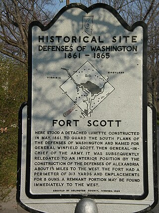
Fort Scott was a detached lunette constructed in May 1861 to guard the south flank of the defenses of Washington during the American Civil War. It was named for General Winfield Scott, who was then General-in-Chief of the Union Army. An historic marker and a small remnant of the fort are the only evidence of the site of the fort on the grounds of what is now Fort Scott Park in Arlington County, Virginia.

The First Battle of Fort McAllister was a series of naval attacks that took place from January 27 to March 3, 1863, in Bryan County, Georgia, during the American Civil War. The commander of the South Atlantic Blockading Squadron Rear Adm. Samuel F. Du Pont decided to test operation of new monitors against Fort McAllister before conducting a major naval operation against Charleston, South Carolina.

Siege artillery is heavy artillery primarily used in military attacks on fortified positions. At the time of the American Civil War, the U.S. Army classified its artillery into three types, depending on the gun's weight and intended use. Field artillery were light pieces that often traveled with the armies. Siege and garrison artillery were heavy pieces that could be used either in attacking or defending fortified places. Seacoast artillery were the heaviest pieces and were intended to be used in permanent fortifications along the seaboard. They were primarily designed to fire on attacking warships. The distinctions are somewhat arbitrary, as field, siege and garrison, and seacoast artillery were all used in various attacks and defenses of fortifications. This article will focus on the use of heavy artillery in the attack of fortified places during the American Civil War.

Fort Lee is a historic American Revolutionary War fort in Salem, Massachusetts. The site, located at a high point next to Fort Avenue on Salem Neck, is a relatively rare fortification from that period whose remains are relatively unaltered. It is an irregular 5-pointed star fort. Although there is some documentary evidence that the Neck was fortified as early as the 17th century, the earthworks built in 1776 are the first clear evidence of the site's military use. Reportedly, the fort had a garrison of 3 officers and 100 artillerymen with 16 guns. The site, of which only overgrown earthworks and a stone magazine survive, was repaired in the 1790s, and rebuilt for the American Civil War. A state cultural resource document states that the fort has not been much modified since the Revolution, and has not been built over. It was garrisoned by the Massachusetts militia in the War of 1812, abandoned afterwards, and rebuilt with four 8-inch columbiads in the Civil War. An Army engineer drawing dated 1872 depicts the fort's five-pointed trace and the four Civil War gun positions. It was also garrisoned during the Spanish–American War.

Fort Pickering is a 17th-century historic fort site on Winter Island in Salem, Massachusetts. Fort Pickering operated as a strategic coastal defense and military barracks for Salem Harbor during a variety of periods, serving as a fortification from the Anglo-Dutch Wars through World War II. Construction of the original fort began in 1643 and it saw use as a military installation into the 20th century. Fort Miller in Marblehead also defended Salem's harbor from the 1630s through the American Civil War. Fort Pickering is a First System fortification named for Colonel Timothy Pickering, born in Salem, adjutant general of the Continental Army and secretary of war in 1795. Today, the remains of the fort are open to the public as part of the Winter Island Maritime Park, operated by the City of Salem.

Fort Sewall is a historic coastal fortification in Marblehead, Massachusetts. It is located at Gale's Head, the northeastern point of the main Marblehead peninsula, on a promontory that overlooks the entrance to Marblehead Harbor. Until 1814 it was called Gale's Head Fort.

Fort Andrew is a former fort built as Gurnet Fort in 1776 for the American Revolutionary War on Gurnet Point in Plymouth, Massachusetts. It became a federal fort and was rebuilt in 1808, and again in 1863 during the Civil War when it received its current name. It is named for John A. Andrew, governor of Massachusetts 1861–1866. In 1863 Fort Standish was built nearby on Saquish Head. After the war, the federal government declared Fort Andrew an inactive military reservation in 1869. The reservation was sold in 1926 and mostly became private property, except for the US Coast Guard light station. A World War II fire control tower was built on the parapet of the old fort. Plymouth lighthouse is also on Gurnet Point, and was moved inside the fort's earthworks to protect it from beach erosion in 1997–1998.

Fort Willard is a former Union Army installation now located in the Belle Haven area of Fairfax County in the U.S. state of Virginia. It is currently undergoing preservation treatment to protect its earthen walls and trenches.

Fort Revere is an 8-acre (3.2 ha) historic site situated on a small peninsula located in Hull, Massachusetts. It is situated on Telegraph Hill in Hull Village and contains the remains of two seacoast fortifications, one from the American Revolution and one that served 1898–1947. There are also a water tower with an observation deck, a military history museum and picnic facilities. It is operated as Fort Revere Park by the Metropolitan Park System of Greater Boston.
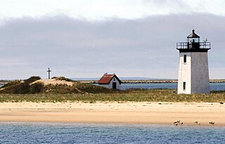
Long Point is a peninsula located in Provincetown, Massachusetts, at the extreme tip of Cape Cod, as it curls back in on itself to create Provincetown Harbor. The Long Point Light was built on this point in 1827. The lighthouse once shared this peninsula with a settlement of fishermen that came to be known as Long Point, Massachusetts. This Provincetown village grew and thrived from 1818 until the late 1850s. When the settlers decided to leave Long Point, they took most of their houses with them – about 30 structures in all – by floating them across the harbor.
Fort Glover was a fort in Marblehead, Massachusetts. Fortifications on the site existed during the American Revolutionary War, the War of 1812, the Civil War, and the Spanish–American War. The fort was located on what is now Riverhead Beach on Ocean Ave in Marblehead, sited to guard the beach and the Marblehead Neck causeway. It was demolished in 1917.

Fort Defiance was a fort that existed from 1794 to after 1865 on Fort Point in Gloucester, Massachusetts. The location protecting the inner harbor was also called Watch House Point.
The Fort at Salisbury Point was a fort in use from 1863 to 1865 in Salisbury, Massachusetts, during the American Civil War. It was also called the Fort at Salisbury Beach. It was a nine-gun earthwork located at the mouth of the Merrimack River at what is now the Salisbury Beach State Reservation, where eventual erosion washed it away. A 1903 reference states it was on the site of the Revolutionary War Fort Nichols, but that site is in doubt, and may have been at the location called Salisbury Point in Amesbury, several miles up the river. The Fort at Salisbury Point was sometimes referred to by local civilians as Fort Nichols in the Civil War era. The fort was designed and built under the supervision of Major Charles E. Blunt of the United States Army Corps of Engineers. An armament report dated June 30, 1866 lists nine heavy guns and one 12-pounder field gun. The heavy guns were three 8-inch smoothbore Rodman guns, three 42-pounder rifled guns, and three 30-pounder rifled guns. From November 1864 to June 1865 it was garrisoned by the 20th Unattached Company of Massachusetts militia. The Museum at Salisbury Point commemorates the soldiers who fought in the war.
Fort Standish was a fort built in 1863 for the American Civil War on Saquish Head in Plymouth, Massachusetts. It was named for Myles Standish, military leader of the Plymouth Colony in the 1620s, and augmented the nearby Fort Andrew on Gurnet Point. It was designed and constructed under the supervision of Major Charles E. Blunt of the United States Army Corps of Engineers. The fort had five gun emplacements with five 8-inch smoothbore guns, along with a bombproof shelter, two magazines, and a well. Outside the fort were a barracks, officers' quarters, and a mess hall. From January to June 1865 the fort was garrisoned by the 27th Unattached Company of Massachusetts militia.

Fort Stark is a former military fortification in New Castle, New Hampshire, United States. Located at Jerry's Point on the southeastern tip of New Castle Island, most of the surviving fort was developed in the early 20th century, following the Spanish–American War, although there were several earlier fortifications on the site, portions of which survive. The fort was named for John Stark, a New Hampshire officer who distinguished himself at the Battle of Bennington in the American Revolution. The purpose of Fort Stark was to defend the harbor of nearby Portsmouth and the Portsmouth Naval Shipyard. The fort remained in active use through the Second World War, after which it was used for reserve training by the US Navy. The property was partially turned over to the state of New Hampshire in 1979, which established Fort Stark Historic Site, and the remainder of the property was turned over in 1983. The grounds are open to the public during daylight hours.
Fort Miller was a coastal defense fort in Marblehead, Massachusetts, in existence circa 1630–1900. Circa 1861 it was renamed for James Miller, a colonel in the War of 1812, distinguished for his actions in the Battle of Lundy's Lane. He was later Collector of the Port in nearby Salem from 1824 to 1849.
The Harbor Defenses of Portsmouth was a United States Army Coast Artillery Corps harbor defense command. It coordinated the coast defenses of Portsmouth, New Hampshire and the nearby Portsmouth Naval Shipyard in Kittery, Maine from 1900 to 1950, both on the Piscataqua River, beginning with the Endicott program. These included both coast artillery forts and underwater minefields. The command originated circa 1900 as the Portsmouth Artillery District, was renamed Coast Defenses of Portsmouth in 1913, and again renamed Harbor Defenses of Portsmouth in 1925.

Stage Fort was a fort that existed from 1635 to 1898 on Stage Head in what is now Stage Fort Park in Gloucester, Massachusetts.


