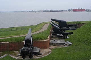
Fort Hancock is a former United States Army fort at Sandy Hook in Atlantic Highlands New Jersey. The coastal artillery base defended the Atlantic coast and the entrance to New York Harbor, with its first gun batteries operational in 1896. The fort served from then until 1950 as part of the Harbor Defenses of New York and predecessor organizations. Between 1874 and 1919, the adjacent US Army Sandy Hook Proving Ground was operated in conjunction with Fort Hancock. It is now part of Fort Hancock Memorial Park. It was preceded by the Fort at Sandy Hook, built 1857–1867 and demolished beginning in 1885.
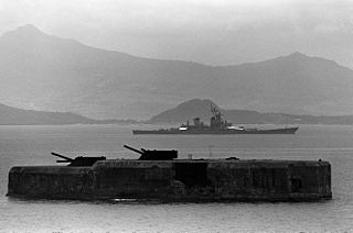
Fort Drum, also known as El Fraile Island, is a heavily fortified island situated at the mouth of Manila Bay in the Philippines, due south of Corregidor Island. Nicknamed a "concrete battleship", the reinforced concrete sea fort, shaped like a battleship, was built by the United States in 1909 as one of the harbor defenses at the wider South Channel entrance to the Bay during the American colonial period.

Fort Strong is a former U.S. Army Coast Artillery fort that occupied the northern third of Long Island in Boston Harbor. The island had a training camp during the American Civil War, and a gun battery was built there in the 1870s. The fort was built in 1893-1906 during the Endicott period of expansion in U.S. coast defense, and was part of the Coast Defenses of Boston. Formerly, it was also known as Long Island Military Reservation. Before World War I, a large station for handling submarine mines was added to the fort's defenses. Prior to World War I the fort was probably manned by over 1,000 soldiers. During World War II, two batteries of 3-inch guns defended channel minefields, but the big guns and other 3-inch batteries were decommissioned. Declared surplus in 1947, the fort served as a Nike missile site until 1961, and was redeveloped in 2005-2009 for a children's summer camp and later a homeless shelter. However, in 2014 the island's bridge was demolished due to safety concerns, and all activity ended.

A fire control tower is a structure located near the coastline, used to detect and locate enemy vessels offshore, direct fire upon them from coastal batteries, or adjust the aim of guns by spotting shell splashes. Fire control towers came into general use in coastal defence systems in the late 19th century, as rapid development significantly increased the range of both naval guns and coastal artillery. This made fire control more complex. These towers were used in a number of countries' coastal defence systems through 1945, much later in a few cases such as Sweden. The Atlantic Wall in German-occupied Europe during World War II included fire control towers.

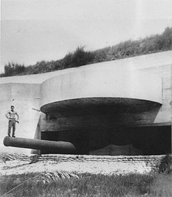
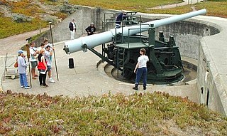
The 16 inch gun M1919 (406 mm) was a large coastal artillery piece installed to defend the United States' major seaports between 1920 and 1946. It was operated by the United States Army Coast Artillery Corps. Only a small number were produced and only seven were mounted; in 1922 and 1940 the US Navy surplussed a number of their own 16-inch/50 guns, which were mated to modified M1919 carriages and filled the need for additional weapons.

Fort H. G. Wright was a United States military installation on Fishers Island in the town of Southold, New York, just two miles off the coast of southeastern Connecticut, but technically in New York. It was part of the Harbor Defenses of Long Island Sound, along with Fort Terry, Fort Michie, and Camp Hero. These forts defended the eastern entrance of Long Island Sound and thus Connecticut's ports and the north shore of Long Island. The fort was named for Union General Horatio G. Wright, a former Chief of Engineers who was born in Clinton, Connecticut.
Seacoast defense was a major concern for the United States from its independence until World War II. Before airplanes, many of America's enemies could only reach it from the sea, making coastal forts an economical alternative to standing armies or a large navy. After the 1940s, it was recognized that fixed fortifications were obsolete and ineffective against aircraft and missiles. However, in prior eras foreign fleets were a realistic threat, and substantial fortifications were built at key locations, especially protecting major harbors.

Odiorne Point State Park is a public recreation area located on the Atlantic seacoast in the town of Rye near Portsmouth, New Hampshire. Among the park's features are the Seacoast Science Center and the remains of the World War II Fort Dearborn. The park offers opportunities for hiking, cycling, picnicking, fishing, and boating.
East Point Military Reservation was a World War I and World War II coastal defense site located in Nahant, Massachusetts. In 1955–62 it was a Nike missile launch site. In 1967 the site was converted into the Marine Science Center of Northeastern University.

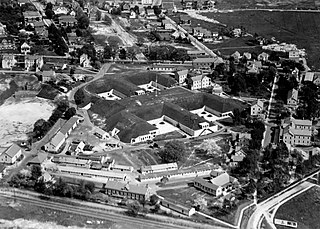
Fort Andrews was created in 1897 as part of the Coast Defenses of Boston, Massachusetts. Construction began in 1898 and the fort was substantially complete by 1904. The fort was named after Major General George Leonard Andrews, an engineer and Civil War commander, who assisted in the construction of nearby Fort Warren in Boston Harbor. It occupies the entire northeast end of Peddocks Island in Boston Harbor, and was originally called the Peddocks Island Military Reservation. Once an active Coast Artillery post, it was manned by hundreds of soldiers and bristled with mortars and guns that controlled the southern approaches to Boston and Quincy Bay. The fort also served as a prisoner-of-war camp for Italian prisoners during World War II, who were employed as laborers following the Italian surrender to the Allies in 1943. Today, the fort is abandoned, and is managed by the Massachusetts Department of Conservation and Recreation, as part of the Boston Harbor Islands National Recreation Area.
Fort Banks was a U.S. Coast Artillery fort located in Winthrop, Massachusetts. It served to defend Boston Harbor from enemy attack from the sea and was built in the 1809 during what is known as the Endicott period, a time in which the coast defenses of the United States were seriously expanded and upgraded with new technology. Today, the fort's mortar battery is on the National Register of Historic Places.

Fort Heath was a US seacoast military installation for defense of the Boston and Winthrop Harbors with an early 20th-century Coast Artillery fort, a 1930s USCG radio station, prewar naval research facilities, World War II batteries, and a Cold War radar station. The fort was part of the Harbor Defenses of Boston and was garrisoned by the United States Army Coast Artillery Corps. The fort's military structures have been replaced by a residential complex, including the luxurious Forth Heath Apartments, and recreation facilities of Small Park, which has both a commemorative wall and an historical marker for Fort Heath.

Fort Duvall was a Coast Artillery fort, part of the Harbor Defenses of Boston, in Massachusetts. What was then called Hog Island in Hull, Massachusetts was acquired by the U.S. government in 1917, and the fort was constructed in the early 1920s. It had only one gun battery, Battery Long, but it mounted the largest caliber weapons in the entire harbor defense system: a pair of 16-inch guns. These were the 16-inch gun M1919, of which only seven were deployed; 16-inch weapons deployed later were supplied by the Navy.
Fort Dawes was a World War II Coast Artillery fort located on Deer Island in Winthrop/Boston, Massachusetts. It was part of the Harbor Defenses of Boston.

The 12-inch coastal defense gun M1895 (305 mm) and its variants the M1888 and M1900 were large coastal artillery pieces installed to defend major American seaports between 1895 and 1945. For most of their history they were operated by the United States Army Coast Artillery Corps. Most were installed on disappearing carriages, with early installations on low-angle barbette mountings. From 1919, 19 long-range two-gun batteries were built using the M1895 on an M1917 long-range barbette carriage. Almost all of the weapons not in the Philippines were scrapped during and after World War II.
The 6-inch gun M1897 (152 mm) and its variants the M1900, M1903, M1905, M1908, and M1 were coastal artillery pieces installed to defend major American seaports between 1897 and 1945. For most of their history they were operated by the United States Army Coast Artillery Corps. They were installed on disappearing carriages or pedestal mountings, and during World War II many were remounted on shielded barbette carriages. Most of the weapons not in the Philippines were scrapped within a few years after World War II.
Fort Church was a World War II United States Army coastal defense fort in Little Compton, Rhode Island. Together with Fort Greene near Point Judith, it superseded all previous heavy gun defenses in the Harbor Defenses of Narragansett Bay.
Fort Greene is a United States Army Reserve installation in the Point Judith area of Narragansett, Rhode Island. During World War II this was a coastal defense fort, and together with Fort Church in Little Compton, it superseded all previous heavy gun defenses in the Harbor Defenses of Narragansett Bay. It is named for General Nathanael Greene of the Revolutionary War, who was born in Rhode Island.

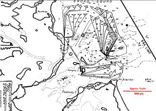
The Harbor Defenses of Boston was a United States Army Coast Artillery Corps harbor defense command. It coordinated the coast defenses of Boston, Massachusetts from 1895 to 1950, beginning with the Endicott program. These included both coast artillery forts and underwater minefields. The command originated circa 1895 as the Boston Artillery District, was renamed Coast Defenses of Boston in 1913, and again renamed Harbor Defenses of Boston in 1925.