
Fort William and Mary was a colonial fortification in Britain's worldwide system of defenses, manned by soldiers of the Province of New Hampshire who reported directly to the royal governor. The fort, originally known as "The Castle", was situated on the island of New Castle, New Hampshire, at the mouth of the Piscataqua River estuary. It was renamed Fort William and Mary circa 1692, after the accession of the monarchs William III and Mary II to the British throne. It was captured by Patriot forces, recaptured, and later abandoned by the British in the Revolutionary War. The fort was renamed Fort Constitution in 1808 following rebuilding. The fort was further rebuilt and expanded through 1899 and served actively through World War II.

Fort McClary is a former defensive fortification of the United States military located along the southern coast at Kittery Point, Maine at the mouth of the Piscataqua River. It was used throughout the 19th century to protect approaches to the harbor of Portsmouth, New Hampshire and the Portsmouth Naval Shipyard in Kittery. The property and its surviving structures are now owned and operated by the State of Maine as Fort McClary State Historic Site, including a blockhouse dating from 1844.

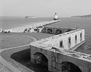
House Island is a private island in Portland Harbor in Casco Bay, Maine, United States. It is part of the City of Portland. The island is only accessible by boat. Public access is prohibited, except for an on request tour sanctioned by the island's owners. House Island includes three buildings on the east side and Fort Scammell on the west side. The buildings are used as summer residences. The island's name derives from the site of an early European house, believed that built by Capt. Christopher Levett, an English explorer of the region.
Fort Preble was a military fort in South Portland, Maine, United States, built in 1808 and progressively added to through 1906. It is now on the campus of Southern Maine Community College.

Fort Winthrop, built in 1808 and named Fort Warren until 1834, was a defensive fortification in Boston Harbor named after John Winthrop, an early governor of the Massachusetts Bay Colony.

Fort Pickering is a 17th-century historic fort site on Winter Island in Salem, Massachusetts. Fort Pickering operated as a strategic coastal defense and military barracks for Salem Harbor during a variety of periods, serving as a fortification from the Anglo-Dutch Wars through World War II. Construction of the original fort began in 1643 and it saw use as a military installation into the 20th century. Fort Miller in Marblehead also defended Salem's harbor from the 1630s through the American Civil War. Fort Pickering is a First System fortification named for Colonel Timothy Pickering, born in Salem, adjutant general of the Continental Army and secretary of war in 1795. Today, the remains of the fort are open to the public as part of the Winter Island Maritime Park, operated by the City of Salem.

Fort Sewall is a historic coastal fortification in Marblehead, Massachusetts. It is located at Gale's Head, the northeastern point of the main Marblehead peninsula, on a promontory that overlooks the entrance to Marblehead Harbor. Until 1814 it was called Gale's Head Fort.

Fort Andrew is a former fort built as Gurnet Fort in 1776 for the American Revolutionary War on Gurnet Point in Plymouth, Massachusetts. It became a federal fort and was rebuilt in 1808, and again in 1863 during the Civil War when it received its current name. It is named for John A. Andrew, governor of Massachusetts 1861–1866. In 1863 Fort Standish was built nearby on Saquish Head. After the war, the federal government declared Fort Andrew an inactive military reservation in 1869. The reservation was sold in 1926 and mostly became private property, except for the US Coast Guard light station. A World War II fire control tower was built on the parapet of the old fort. Plymouth lighthouse is also on Gurnet Point, and was moved inside the fort's earthworks to protect it from beach erosion in 1997–1998.

Fort Wolcott was a fortification on the small Goat Island in Newport Harbor of Narragansett Bay less than 1 mile west of the city of Newport, Rhode Island. The attacks on HMS St John and HMS Liberty occurred near the fort.

Acushnet Fort was a fort that existed from 1776 to around 1820 on Eldridge Point in New Bedford, Massachusetts. It was originally built with Commonwealth resources during the American Revolution in 1776 with ten guns. Rebuilt in 1808 under the federal second system of fortifications, it could accommodate 40 men and had six guns and a magazine.
Eastern Point Fort was a fort that was garrisoned or maintained from 1863 to 1867 on Eastern Point in Gloucester, Massachusetts, built for the American Civil War. References indicate the name has also been used to refer to the much-older Stage Fort across the harbor.
Fort Standish was a fort built in 1863 for the American Civil War on Saquish Head in Plymouth, Massachusetts. It was named for Myles Standish, military leader of the Plymouth Colony in the 1620s, and augmented the nearby Fort Andrew on Gurnet Point. It was designed and constructed under the supervision of Major Charles E. Blunt of the United States Army Corps of Engineers. The fort had five gun emplacements with five 8-inch smoothbore guns, along with a bombproof shelter, two magazines, and a well. Outside the fort were a barracks, officers' quarters, and a mess hall. From January to June 1865 the fort was garrisoned by the 27th Unattached Company of Massachusetts militia.

Fort Norfolk is a historic fort and national historic district located at Norfolk, Virginia. With the original buildings having been built between 1795 and 1809, the fort encloses 11 buildings: main gate, guardhouse, officers' quarters, powder magazine, and carpenter's shop. Fort Norfolk is the last remaining fortification of President George Washington's 18th century harbor defenses, later termed the first system of US fortifications. It has served as the district office for the U.S. Army Engineer District, Norfolk since 1923.
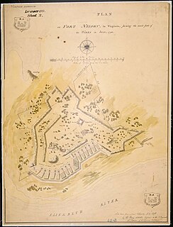
Fort Nelson was a fort located on Hospital Point in Portsmouth, Virginia, which is currently the site of the Portsmouth Naval Hospital. The fort was named for Thomas Nelson Jr., governor of Virginia in 1781. It and Fort Norfolk were built to guard the Elizabeth River, including the cities of Norfolk and Portsmouth and the Gosport Navy Yard. The fort was originally built by patriot forces with funding from the Virginia government in 1776 during the American Revolutionary War, but destroyed when the British occupied the area in 1779. A British map shows that they rebuilt the fort by 1781. Following the Revolution, the fort was again rebuilt in 1794 under the first system of US fortifications, was garrisoned in the War of 1812, but was demolished in 1827 to make room for the naval hospital. The fort was again rebuilt by Confederate forces in 1861, but the Confederates evacuated the area in May 1862 and the fort was eventually demolished.

Fort Sumner was a coastal defense fortification on Munjoy Hill in Portland, Maine, United States. It was built in 1794 as part of the First System of coastal fortifications built by the United States. It was reportedly originally named Fort Allen after the nearby Revolutionary War battery that probably became part of Fort Sumner, but was renamed in 1797 after Increase Sumner, the incumbent Governor of Massachusetts, of which Maine was then a part. The location is now Fort Sumner Park, also called Standpipe Park, at 60 North Street.

Fort Gansevoort was a former United States Army fort in the New York City borough of Manhattan. It was also called the White Fort due to its whitewashed exterior. The fort was named for Peter Gansevoort, a Revolutionary War officer. It was located between Gansevoort Street and West 12th Street, near the west end of Gansevoort Street, strategically positioned to defend the Hudson River. The fort was completed in 1812, shortly after the outbreak of the War of 1812, and mounted 22 guns, along with a shot furnace, magazine, arsenal, and barracks. Some sources state that construction began in 1808; however, the fort does not appear in the Secretary of War's report on fortifications for December 1811. Forts built with state or local resources did not appear in these reports. The fort was part of what was later called the second system of US fortifications. It did not see action, as New York City was not attacked in that war. It was demolished in either 1849 or 1854. It was on the site of a previous weapons development center, where George Bomford developed the first columbiad cannon.

Fort Powhatan is a former river defense fort located at Windmill Hill near Garysville, Virginia, 2.5 miles (4.0 km) southeast of Flowerdew Hundred Plantation in Prince George County, Virginia. The fort was named for the area's Powhatan tribe of indigenous people; the name is also an English term for their leader. It is on the south bank of the James River, sited to prevent enemy vessels proceeding upriver to Richmond. The first fort on the site was a two-gun battery called Hood's Battery, built in 1779 during the American Revolutionary War and named after the owner of the plantation it was on. In January 1781, British forces under Benedict Arnold attacked and dismantled the battery and went on to burn Richmond. Later that year a larger fort was built, named Fort Hood. In 1808 this was replaced by the federal government with Fort Powhatan, part of what was later called the second system of US fortifications. The fort was not attacked in the War of 1812. In 1862, during the American Civil War, Confederate forces added a new earthwork battery on the site; the fort area was captured by Union forces in 1863. The fort was abandoned at the end of the war in 1865.

Stage Fort was a fort that existed from 1635 to 1898 on Stage Head in what is now Stage Fort Park in Gloucester, Massachusetts.
Fort Greene in Newport, Rhode Island was a small fort built circa 1794 at Battery Park in the Point section of Newport, last active in the War of 1812. It was named for General Nathanael Greene of the Revolutionary War, who was born in Rhode Island. It was built as part of the First System of US seacoast fortifications circa 1794. The location is now Battery Park at Easton's Point, which was sometimes called North Point in the 18th century. It was on the site of a previous battery built in the American Revolution with state resources, called the North Battery. The seawall remains from Fort Greene and is curved at this point.


