Brigalow Belt

Last updated

Brigalow Belt
Brigalow tropical savanna
IBRA 6.1 Brigalow Belt North.png
Brigalow Belt North (BBN) (IBRA
IBRA 6.1 Brigalow Belt South.png
Brigalow Belt South (BBS) (IBRA)
Ecology
Realm Australasian
Biome tropical and subtropical grasslands, savannas, and shrublands
Borders
Geography
Area408,242 km2 (157,623 sq mi)
Country Australia
States
Conservation
Conservation status Critical/endangered
Protected17,891 km² (4%) [1]

The Brigalow Belt is a wide band of acacia-wooded grassland that runs between tropical rainforest of the coast and the semi-arid interior of Queensland and northern New South Wales, Australia. The Interim Biogeographic Regionalisation for Australia (IBRA) divides the Brigalow Belt into two IBRA regions, or bioregions, Brigalow Belt North (BBN) and Brigalow Belt South (BBS). The North and South Brigalow Belt are two of the 85 bioregions across Australia and the 15 bioregions in Queensland. Together they form most of the Brigalow tropical savanna ecoregion. [2] [3]

Contents

Location and description

The Northern Brigalow Belt covers just over 135,000 square kilometres (52,124 sq mi) and runs from just north of Townsville to Emerald and Rockhampton on the Tropic of Capricorn, while the Southern Brigalow Belt runs from there down to the Queensland/New South Wales border and a little beyond, until the habitat becomes the eucalyptus dominated Eastern Australian temperate forests.

This large, complex strip of countryside covers an area of undulating to rugged slopes, consisting of ranges as well as plains of ancient sand and clay deposits, basalt and alluvium. The Northern Brigalow Belt includes the coal producing Bowen Basin, with the nearby Drummond Basin and the fertile Peak Downs areas. The southern belt, which begins with the sandstone gorges of the Carnarvon Range of the Great Dividing Range, runs into the huge Great Artesian Basin. The south-west side includes the farming area of Darling Downs.

A number of important rivers drain the Brigalow Belt. The large Fitzroy River system and the Belyando and Burdekin rivers near the tropics all drain eastwards, while the south-western areas drain westwards into the Murray–Darling basin via the Maranoa, Warrego and Condamine Rivers.

In the north, there are tropical summer rains and warm weather all year round, while in the south the winter is slightly cooler and there is more rainfall outside of the summer months. Throughout the belt, the interior, with less than 500 mm of rainfall per year, is drier than the coast, which may have 750 mm or more.

Flora

Brigalow tree, coastal central Queensland. Brigalow tree.jpg
Brigalow tree, coastal central Queensland.

The characteristic plant communities are woodlands of highly water stress tolerant brigalow (Acacia harpophylla), a slender acacia tree which thrives on the clay soil and once covered much of the area especially the fertile lowlands. Most of the brigalow has been cleared to make agricultural land and eucalypt woodlands of silver-leaved and narrow-leaved ironbarks, poplar box and other boxes, blackbutt and coolibah are now intact primarily on the higher slopes. [4] [5] [6] [7] [8] [9] [ clarification needed ]

Dichanthium grasslands are another typical habitat of the area while pockets of thicker woodland of brigalow mixed with Casuarina cristata and ooline occur in moister valleys and vine thickets, wetlands, and softwood scrubs are sometimes found although in their undeveloped state, these specialised micro-habitats are rare today. There is a particularly rich variety of habitats in areas such as Isla Gorge and Blackdown Tableland in the sandstone belt of the Carnarvon Range. The Northern Brigalow Belt is one of fifteen national biodiversity hotspots in Australia. [10]

Fauna

The region is home to the unadorned rock-wallaby and the black-striped wallaby, which lives in the areas of vine thicket along with a wingless dung beetle ( Onthophagus apterus ). Two endangered mammals are found in the Brigalow Belt; the bridled nail-tail wallaby in Taunton and Idalia National Parks, and the burrowing northern hairy-nosed wombat in the grassland and eucalyptus of Epping Forest National Park. There are also populations of dunnart, wallaby, bat and koala. Birds found here include black-throated finch and russet-tailed thrush, while endemic reptiles include the Fitzroy River turtle. [11]

A variety of spiders and insects are found there, including Euoplos dignitas , an armoured trapdoor spider discovered in 2023. [12]

Already extinct fauna include the white-footed rabbit-rat and the Darling Downs hopping mouse. [13]

Threats and preservation

Map of the Brigalow Belt North, showing protected areas BBN NationalParks StateForest.jpg
Map of the Brigalow Belt North, showing protected areas

Together with the Mulga Lands, the Brigalow Belt are where most of Queensland's land clearing is occurring. [14] Much of the brigalow woodland has been cleared or radically reduced to the extent that some wildlife, failing to thrive in the altered environment, has become extinct here with a number of the remaining communities threatened or endangered. The clearance of brigalow and poplar box is ongoing as there are a number of nature reserves of which do protect the various types of habitat found in the Belt including brigalow and eucalyptus woodland, grassland, vine thicket, high peaks, sandstone gorges and wetlands however these tend to be located on the sandstone uplands rather than the fertile lowlands, where the brigalow woodlands are still vulnerable to clearance and are often limited to small areas of parkland.[ clarification needed ] The grasslands of the region are also under threat from introduced pasture grasses such as buffelgrass and weeds such as Congress weed. One particular threat comes from alterations to natural flow patterns caused by the addition of dams and weirs which impact the riverine and floodplain plant and animal species. [15]

Protected areas

A little more than two per cent of the Brigalow Belt lies within national parks and other protected areas. [16] The largest national parks in the Brigalow Belt are: Taunton (the largest at 115 km2); Epping Forest, Dipperu, Bowling Green Bay, Goodedulla National Park, Chesterton Range National Park, Homevale National Park, Blackdown Tableland National Park, Expedition National Park, and Carnarvon National Park.

Subregions

IBRA subregions of the Brigalow Belt North include Townsville Plains, Bogie River Hills, Cape River Hills, Beucazon Hills, Wyarra Hills, Northern Bowen Basin, Belyando Downs, Upper Belyando Floodout, Anakie Inlier, Basalt Downs, Isaac–Comet Downs, Nebo–Connors Ranges, South Drummond Basin and Marlborough Plains.

IBRA regions and subregions: IBRA7
IBRA region / subregionIBRA codeArea States Location in Australia
Brigalow Belt North BBN33,790,510 hectares (83,498,200 acres) Qld IBRA 6.1 Brigalow Belt North.png
Townsville Plains BBN01763,495 ha (1,886,640 acres)
Bogie River Hills BBN021,054,392 ha (2,605,460 acres)
Cape River Hills BBN03747,393 ha (1,846,850 acres)
Beucazon Hills BBN0495,821 ha (236,780 acres)
Wyarra Hills BBN05397,935 ha (983,320 acres)
Northern Bowen Basin BBN061,316,957 ha (3,254,270 acres)
Belyando Downs BBN071,772,127 ha (4,379,020 acres)
Upper Belyando Floodout BBN08466,275 ha (1,152,190 acres)
Anakie Inlier BBN09382,284 ha (944,640 acres)
Basalt Downs BBN101,274,731 ha (3,149,930 acres)
Isaac-Comet Downs BBN112,693,397 ha (6,655,530 acres)
Nebo-Connors Ranges BBN12449,269 ha (1,110,170 acres)
South Drummond Basin BBN131,009,244 ha (2,493,900 acres)
Marlborough Plains BBN141,250,611 ha (3,090,330 acres)
IBRA regions and subregions: IBRA7
IBRA region / subregionIBRA codeArea States Location in Australia
Brigalow Belt South BBS27,219,776 hectares (67,261,530 acres)Qld / NSW IBRA 6.1 Brigalow Belt South.png
Claude River Downs BBS011,026,214 ha (2,535,830 acres)
Woorabinda BBS02749,785 ha (1,852,760 acres)
Boomer Range BBS03220,541 ha (544,970 acres)
Mount Morgan Ranges BBS041,275,970 ha (3,153,000 acres)
Callide Creek Downs BBS0530,133 ha (74,460 acres)
Arcadia BBS06715,288 ha (1,767,520 acres)
Dawson River Downs BBS07982,807 ha (2,428,570 acres)
Banana-Auburn Ranges BBS081,547,555 ha (3,824,090 acres)
Buckland Basalts BBS09281,306 ha (695,120 acres)
Carnarvon Ranges BBS102,263,686 ha (5,593,690 acres)
Taroom Downs BBS11652,005 ha (1,611,140 acres)
Southern Downs BBS124,264,666 ha (10,538,220 acres)
BarakulaBBS131,301,712 ha (3,216,600 acres)
Dulacca Downs BBS14162,442 ha (401,400 acres)
Weribone High BBS15966,510 ha (2,388,300 acres)
Tara DownsBBS16511,339 ha (1,263,550 acres)
Eastern Darling Downs BBS171,697,945 ha (4,195,710 acres)
Inglewood Sandstones BBS181,219,008 ha (3,012,230 acres)
Moonie-Commoron Floodout BBS19750,661 ha (1,854,920 acres)
Moonie-Barwon Interfluve BBS20765,231 ha (1,890,930 acres)
Northern Basalts BBS21624,671 ha (1,543,600 acres)
Northern Outwash BBS22700,241 ha (1,730,330 acres)
Pilliga Outwash BBS23535,392 ha (1,322,980 acres)
Pilliga BBS241,732,137 ha (4,280,200 acres)
Liverpool Plains BBS25941,752 ha (2,327,120 acres)
Liverpool Range BBS26521,960 ha (1,289,800 acres)
Talbragar Valley BBS27203,894 ha (503,830 acres)
Narrandool BBS28303,754 ha (750,590 acres)

Related Research Articles

Erringibba is a national park at Glenmorgan in the far west of the Darling Downs region of southern Queensland, Australia, 329 km west of Brisbane. The park was established in 1999 and covers 8.77 km2 (3.39 sq mi). The park lies within the catchment area of the Condamine River and the Brigalow Belt South bioregion.

Epping Forest is a national park in Queensland, Australia, 855 km northwest of Brisbane. The park is a scientific national park so it is not open to the public. Only scientists, rangers and volunteers may visit the park. The park lies within the Brigalow Belt North bioregion. It is within the Drummond Basin geological basin and the Belyando River water catchment area. The park was established to protect a species of wombat, the northern hairy-nosed wombat that is the world’s largest burrowing herbivore.

Taunton National Park is situated near the town of Dingo approximately 135 km inland from Rockhampton in eastern Central Queensland, Australia. The park encompasses an area of 11,626 ha within the Northern Brigalow Belt bioregion of Queensland; a region widely recognised to contain considerable biodiversity.

<span class="mw-page-title-main">Carnarvon xeric shrublands</span> Terrestrial ecoregion in Western Australia

The Carnarvon xeric shrublands is a deserts and xeric shrublands ecoregion of Western Australia. The ecoregion is coterminous with the Carnarvon Interim Biogeographic Regionalisation for Australia (IBRA) bioregion.

<span class="mw-page-title-main">Murchison (Western Australia)</span> Bioregion in Western Australia

The Murchison is a loosely defined area of Western Australia located within the interior of the Mid West region. It was the subject of a major gold rush in the 1890s and remains a significant mining district. The Murchison is also included as an interim Australian bioregion. The bioregion is loosely related to the catchment area of the Murchison River and has an area of 281,205 square kilometres (108,574 sq mi).

<span class="mw-page-title-main">Barkly Tableland</span> Region in the Northern Territory, Australia

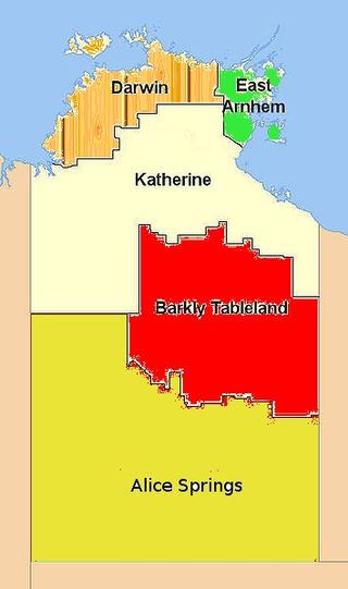
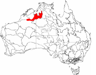
The Barkly Tableland is a rolling plain of grassland in Australia. It runs from the eastern part of the Northern Territory into western Queensland. It is one of the five regions in the Northern Territory and covers 283,648 square kilometres (109,517 sq mi), 21% of the Northern Territory. The Barkly Tableland runs parallel to the southern shore of the Gulf of Carpentaria, from about Mount Isa, Queensland to near Daly Waters.

<span class="mw-page-title-main">Ord Victoria Plain</span> Bioregion in Australia

The Ord Victoria Plain, an interim Australian bioregion, is located in the Northern Territory and Western Australia, comprising 12,540,703 hectares.

<span class="mw-page-title-main">Yalgoo bioregion</span> Bioregion in Western Australia

Yalgoo is an interim Australian bioregion located in Western Australia. It has an area of 5,087,577 hectares. The bioregion, together with the Avon Wheatbelt and Geraldton Sandplains bioregions, is part of the larger Southwest Australia savanna ecoregion as classified by the World Wildlife Fund.

<span class="mw-page-title-main">Carpentaria tropical savanna</span> Ecoregion in Australia

The Carpentaria tropical savanna is a tropical and subtropical grasslands, savannas, and shrublands ecoregion in northern Australia.

<span class="mw-page-title-main">Einasleigh Uplands</span> Bioregion in Queensland, Australia

The Einasleigh Uplands is an interim Australian bioregion, with vegetation consisting of savanna and woodland located on a large plateau in inland Queensland, Australia. It corresponds to the Einasleigh Uplands savanna ecoregion, as identified by the World Wildlife Fund.

<span class="mw-page-title-main">Victoria Plains tropical savanna</span> Ecoregion in Australia

The Victoria Plains tropical savanna is a tropical and subtropical grasslands, savannas, and shrublands ecoregion in northwestern Australia.

<span class="mw-page-title-main">Mulga Lands</span>

The Mulga Lands are an interim Australian bioregion of eastern Australia consisting of dry sandy plains with low mulga woodlands and shrublands that are dominated by Acacia aneura (mulga). The Eastern Australia mulga shrublands ecoregion is coterminous with the Mulga Lands bioregion.

<span class="mw-page-title-main">Southeast Australia temperate savanna</span>

The Southeast Australia temperate savanna ecoregion is a large area of grassland dotted with eucalyptus trees running north–south across central New South Wales, Australia.

<span class="mw-page-title-main">Western Australian mulga shrublands</span> Terrestrial ecoregion in Western Australia

The Western Australian Mulga shrublands is a deserts and xeric shrublands ecoregion of inland Western Australia. It is one of Australia's two mulga ecoregions, characterized by dry woodlands of mulga trees interspersed with areas of grassland and scrub.

<span class="mw-page-title-main">Pilbara shrublands</span> Terrestrial ecoregion in Western Australia

The Pilbara shrublands is a deserts and xeric shrublands ecoregion in Western Australia. It is coterminous with the Pilbara IBRA region. For other definitions and uses of "Pilbara region" see Pilbara.

<span class="mw-page-title-main">Mitchell Grass Downs</span> Ecoregion in Australia

The Mitchell Grass Downs is a tropical and subtropical grasslands, savannas, and shrublands ecoregion in northeastern Australia. It is a mostly treeless grassland, characterised by Mitchell grasses .

<span class="mw-page-title-main">South Eastern Queensland</span> Region in Australia

South Eastern Queensland is an interim Australian bioregion located in south-eastern Queensland and north-eastern New South Wales. It has an area of 7,804,921 hectares. It is one of the most biodiverse bioregions in Australia. The bioregion is home to eucalypt forests and woodlands, with rainforests on mountain slopes and in stream valleys and wallum heaths near the coast. South Eastern Queensland bioregion is the northernmost part of the Eastern Australian temperate forests ecoregion.

References

  1. Dinerstein, Eric; Olson, David; et al. (June 2017). "An Ecoregion-Based Approach to Protecting Half the Terrestrial Realm". BioScience. 67 (6): 534–545. doi: 10.1093/biosci/bix014 . PMC   5451287 . PMID   28608869.{{cite journal}}: CS1 maint: date and year (link) Supplemental material 2 table S1b.
  2. "Brigalow tropical savanna". Terrestrial Ecoregions. World Wildlife Fund.
  3. Stanton, J. P. (James Peter); Morgan, M. G; University of New England. School of Natural Resources (1977), The rapid selection and appraisal of key and endangered sites : the Queensland case study, the University of New England School of Natural Resources, p. 3, retrieved 11 February 2022
  4. Fensham, R.J.; McCosker, J.C.; Cox, M.J. (1998). "Estimating clearance of Acacia-dominated ecosystems in central Queensland using land-system mapping data". Australian Journal of Botany. 46 (2): 305–319. doi:10.1071/bt96129.
  5. Young, P.A.R., B.A. Wilson, J.C. McCosker, R.J. Fensham, G. Morgan, and P. M. Taylor. 1999. Brigalow Belt. Pages 11/1-11/81 in P. Sattler and R. Williams, editors. The Conservation Status of Queensland's Bioregional Ecosystems. Environmental Protection Agency, Brisbane, Australia
  6. Thackway, R., and I.D. Creswell. 1995. An Interim Biogeographic Regionalisation for Australia: A framework for establishing a national system of reserves, Version 4. Australian Nature Conservation Agency, Canberra, Australia.
  7. Arnold, S.; Thornton, C.; Baumgartl, T. (2012). "Ecohydrological feedback as a land restoration tool in the semi-arid Brigalow Belt, QLD, Australia". Agriculture, Ecosystems and Environment. 163: 61–71. doi:10.1016/j.agee.2012.05.020.
  8. Arnold, S., P. Audet, D. Doley, and T. Baumgartl. 2013. Hydropedology and ecohydrology of the Brigalow Belt, Australia: opportunities for ecosystem rehabilitation in semi-arid environments. Vadose Zone Journal, https://www.soils.org/publications/vzj/articles/12/4/vzj2013.03.0052?highlight=&search-result=1)
  9. Arnold, S., Y. Kailichova, and T. Baumgartl. 2014. Germination of Acacia harpophylla (Brigalow) seeds in relation to soil water potential: implications for rehabilitation of a threatened ecosystem. PeerJ, https://peerj.com/articles/268/
  10. "Brigalow tropical savanna". Terrestrial Ecoregions. World Wildlife Fund.
  11. Ponce Reyes, Rocio; Firn, Jennifer; Nicol, Sam; Chades, Iadine; Martin, Tara; Stratford, Danial; Whitten, Stuart; Carwardine, Josie. Priority threat management for imperilled species of the Queensland Brigalow Belt. CSIRO: CSIRO; 2016. https://doi.org/10.4225/08/58542c54413ee
  12. Planas, Antonio (21 March 2023). "Super-size trapdoor spider discovered in Australia". NBC News. Archived from the original on 23 March 2023. Retrieved 23 March 2023.
  13. Ponce Reyes, Rocio; Firn, Jennifer; Nicol, Sam; Chades, Iadine; Martin, Tara; Stratford, Danial; Whitten, Stuart; Carwardine, Josie. Priority threat management for imperilled species of the Queensland Brigalow Belt. CSIRO: CSIRO; 2016. https://doi.org/10.4225/08/58542c54413ee
  14. Morris, Nathan (10 April 2022). "Beef industry could struggle to achieve net zero by 2030 if Queensland keeps clearing land". ABC News . Australian Broadcasting Corporation . Retrieved 9 August 2023.
  15. Ponce Reyes, Rocio; Firn, Jennifer; Nicol, Sam; Chades, Iadine; Martin, Tara; Stratford, Danial; Whitten, Stuart; Carwardine, Josie. Priority threat management for imperilled species of the Queensland Brigalow Belt. CSIRO: CSIRO; 2016. https://doi.org/10.4225/08/58542c54413ee
  16. "Expedition National Park: Nature, culture and history". Department of National Parks, Recreation, Sport and Racing. 19 October 2009. Retrieved 9 July 2013.

21°59′S148°07′E / 21.983°S 148.117°E / -21.983; 148.117