Brimfield, Illinois

Last updated

Brimfield
Peoria County Illinois Incorporated and Unincorporated areas Brimfield Highlighted.svg
Location of Brimfield in Peoria County, Illinois.
Illinois in United States (US48).svg
Location of Illinois in the United States
Coordinates: 40°50′18″N89°53′2″W / 40.83833°N 89.88389°W / 40.83833; -89.88389
CountryUnited States
StateIllinois
County Peoria
Government
  MayorDan Fishel
Area
[1]
  Total0.83 sq mi (2.14 km2)
  Land0.82 sq mi (2.13 km2)
  Water0.01 sq mi (0.01 km2)
Population
 (2020)
  Total778
  Density947.62/sq mi (365.90/km2)
Time zone UTC-6 (CST)
  Summer (DST) UTC-5 (CDT)
Area code 309
FIPS code 17-08303
Website www.brimfieldil.org

Brimfield (formerly Charleston) is a village in Peoria County, Illinois, United States.

Contents

The population was 868 at the 2010 census. Brimfield is part of the Peoria, Illinois Metropolitan Statistical Area.

Geography

Brimfield is located at 40°50′18″N89°53′2″W / 40.83833°N 89.88389°W / 40.83833; -89.88389 (40.838210, -89.883999). [2]

According to the 2010 census, Brimfield has a total area of 0.785 square miles (2.03 km2), of which 0.78 square miles (2.02 km2) (or 99.36%) is land and 0.005 square miles (0.01 km2) (or 0.64%) is water. [3]

Demographics

Historical population
CensusPop.Note
1860 565
1880 832
1890 719−13.6%
1900 677−5.8%
1910 576−14.9%
1920 6177.1%
1930 572−7.3%
1940 6188.0%
1950 6484.9%
1960 6561.2%
1970 72911.1%
1980 89022.1%
1990 797−10.4%
2000 93317.1%
2010 868−7.0%
2020 778−10.4%
U.S. Decennial Census [4]

As of the census [5] of 2000, there were 933 people, 362 households, and 245 families residing in the village. The population density was 1,238.7 inhabitants per square mile (478.3/km2). There were 369 housing units at an average density of 489.9 per square mile (189.2/km2). The racial makeup of the village was 98.50% White, 0.32% Native American, 0.21% from other races, and 0.96% from two or more races. Hispanic or Latino of any race were 0.75% of the population.

There were 362 households, out of which 37.0% had children under the age of 18 living with them, 55.2% were married couples living together, 10.2% had a female householder with no husband present, and 32.3% were non-families. 27.1% of all households were made up of individuals, and 11.9% had someone living alone who was 65 years of age or older. The average household size was 2.57 and the average family size was 3.18.

In the village, the population was spread out, with 0% under the age of 18, 0% from 18 to 24, 0% from 25 to 44, 0% from 45 to 64, and 100% who were 65 years of age or older. The median age was 34 years. For every 100 females, there were 96.4 males. For every 100 females age 18 and over, there were 84.2 males.

The median income for a household in the city was $38,542, and the median income for a family was $42,083. Males had a median income of $36,250 versus $23,068 for females. The per capita income for the city was $16,090. About 6.6% of families and 8.5% of the population were below the poverty line, including 11.3% of those under age 18 and 1.8% of those age 65 or over.

Schools

Brimfield has both schools in Brimfield Community Unit School District 309: Brimfield Grade School and Brimfield High School. [6]

Related Research Articles

<span class="mw-page-title-main">Peoria County, Illinois</span> County in Illinois, United States

Peoria County is located in the U.S. state of Illinois. The 2020 United States Census listed its population at 181,830. Its county seat is Peoria. Peoria County is part of the Peoria, IL Metropolitan Statistical Area.

<span class="mw-page-title-main">Versailles, Illinois</span> Village in Illinois, United States

Versailles is a village in Brown County, Illinois, United States. The population was 446 at the 2020 census. The village's name is pronounced differently from the French city of the same name: vər-SAYLZ.

<span class="mw-page-title-main">La Rose, Illinois</span> Village in Illinois, United States

La Rose is a village in Bell Plain Township, Marshall County, Illinois, United States. The population was 98 at the 2020 census, down from 144 in 2010. It is part of the Peoria Metropolitan Statistical Area.

<span class="mw-page-title-main">Washburn, Illinois</span> Village in Illinois, United States

Washburn is a village mostly in Woodford County, with a small northerly portion in Marshall County, Illinois, United States. The population was 1,032 at the 2020 census. It is part of the Peoria Metropolitan Statistical Area.

<span class="mw-page-title-main">Bartonville, Illinois</span> Village in Illinois, United States

Bartonville is a village in Peoria County, Illinois, United States. The population was 6,471 at the 2010 census. Bartonville is a suburb of Peoria and is part of the Peoria, Illinois Metropolitan Statistical Area.

<span class="mw-page-title-main">Bellevue, Illinois</span> Village in Illinois, United States

Bellevue is a village in Peoria County, Illinois, United States. The population was 1,978 at the 2010 census. Bellevue is a suburb of Peoria and is part of the Peoria, Illinois Metropolitan Statistical Area.

<span class="mw-page-title-main">Dunlap, Illinois</span> Village in Illinois, United States

Dunlap is a village in Peoria County, Illinois, United States. Its population was 1,386 people as of the 2010 census. Dunlap is part of the Peoria metropolitan area and growth in the city of Peoria is extending towards the village. There are only a handful of businesses in the village's 16 blocks.

<span class="mw-page-title-main">Glasford, Illinois</span> Village in Illinois, United States

Glasford is a village in Peoria County, Illinois, United States. The population was 866 at the 2020 census. Glasford is part of the Peoria, Illinois Metropolitan Statistical Area.

<span class="mw-page-title-main">Kingston Mines, Illinois</span> Village in Illinois, United States

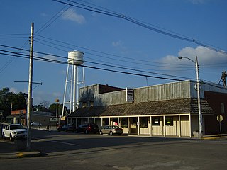
Kingston Mines is a village in Peoria County, Illinois, United States. The population was 259 at the 2000 census. It is part of the Peoria, Illinois Metropolitan Statistical Area. Located on the Illinois River, it was a shipping port, loading coal from the nearby mines.

<span class="mw-page-title-main">Mapleton, Illinois</span> Village in Illinois, United States

Mapleton is a small village in Peoria County, Illinois, United States. The population was 227 at the 2000 census. Mapleton is part of the Peoria, Illinois Metropolitan Statistical Area. There are four different plants in Mapleton, all located along U.S. Route 24: an Evonik chemical plant, a Lonza Group plant, a Caterpillar Inc. foundry, and an Ingredion facility; together, the large industrial complex forms one of Mapleton's most significant employers and a good source of skilled employees and good jobs.

<span class="mw-page-title-main">Norwood, Illinois</span> Village in Illinois, United States

Norwood is a village in Peoria County, Illinois, United States. The population was 478 at the 2010 census. Norwood, just outside Peoria, is part of the Peoria, Illinois Metropolitan Statistical Area.

Rome is a census-designated place (CDP) in Medina Township, Peoria County, Illinois, United States. The population of the CDP was 1,738 at the 2010 census. Rome is part of the Peoria, Illinois Metropolitan Statistical Area.

<span class="mw-page-title-main">West Peoria, Illinois</span> City in Illinois, United States

West Peoria is a city in Peoria County, Illinois, United States. The population was 4,458 at the 2010 census. West Peoria is a suburb of Peoria and is part of the Peoria, Illinois Metropolitan Statistical Area.

<span class="mw-page-title-main">Bay View Gardens, Illinois</span> Village in Illinois, United States

Bay View Gardens is a village in Woodford County, Illinois, United States. The population was 378 at the 2010 census, up from 366 in 2000. The village is part of the Peoria, Illinois Metropolitan Statistical Area.

<span class="mw-page-title-main">Congerville, Illinois</span> Village in Illinois, United States

Congerville is a village in Woodford County, Illinois, United States. The population was 474 as of the 2010 census, up from 466 in 2000. Congerville is part of the Peoria, Illinois Metropolitan Statistical Area.

<span class="mw-page-title-main">Germantown Hills, Illinois</span> Village in Illinois, United States

Germantown Hills is a village in Woodford County, Illinois, approximately 8 miles (13 km) northeast of Peoria. Germantown Hills is the only incorporated community in Worth Township. As of the 2010 census, the village had a total population of 3,438. Largely an agricultural community until its incorporation in 1954, Germantown Hills is now a growing bedroom community in the Peoria Metropolitan Area.

<span class="mw-page-title-main">Panola, Illinois</span> Village in Illinois, United States

Panola is a village in Woodford County, Illinois, United States. The population was 45 at the 2010 census. It is part of the Peoria, Illinois Metropolitan Statistical Area.

<span class="mw-page-title-main">Secor, Illinois</span> Village in Illinois, United States

Secor is a village in Clayton Township, Woodford County, Illinois, United States. The population was 373 at the 2010 census. It is part of the Peoria, Illinois Metropolitan Statistical Area. Secor is located just off U.S. Route 24 between El Paso and Eureka.

<span class="mw-page-title-main">Brimfield, Massachusetts</span> Town in Massachusetts, United States

Brimfield is a town in Hampden County, Massachusetts, United States. The population was 3,694 at the 2020 census. It is part of the Springfield, Massachusetts Metropolitan Statistical Area.

<span class="mw-page-title-main">Abbott, Texas</span> City in Texas, United States

Abbott is a city in Hill County, Texas, United States. It is 24.7 miles (39.8 km) north of Waco, along Interstate 35. The population was 352 in 2020.

References

  1. "2020 U.S. Gazetteer Files". United States Census Bureau. Retrieved March 15, 2022.
  2. "US Gazetteer files: 2010, 2000, and 1990". United States Census Bureau. February 12, 2011. Retrieved April 23, 2011.
  3. "G001 - Geographic Identifiers - 2010 Census Summary File 1". United States Census Bureau. Archived from the original on February 13, 2020. Retrieved August 2, 2015.
  4. "Census of Population and Housing". Census.gov. Retrieved June 4, 2015.
  5. "U.S. Census website". United States Census Bureau . Retrieved January 31, 2008.
  6. "Brimfield School Report Cards". Brimfield Community Unit School District 309. Archived from the original on March 14, 2018. Retrieved March 13, 2018.