
A ZIP Code is a system of postal codes used by the United States Postal Service (USPS). Introduced on July 1, 1963, the basic format consisted of five digits. In 1983, an extended ZIP+4 code was introduced; it included the five digits of the ZIP Code, followed by a hyphen and four digits that designated a more specific location.

Peoria County is located in the U.S. state of Illinois. The 2020 United States Census listed its population at 181,830. Its county seat is Peoria. Peoria County is part of the Peoria, IL Metropolitan Statistical Area.

Chillicothe is a city on the Illinois River in Peoria County, Illinois, United States. The population was 6,097 at the 2010 census. Chillicothe is just north of the city of Peoria and is part of the Peoria Metropolitan Statistical Area.

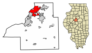
Peoria is a city in and county seat of Peoria County, Illinois, United States. Located on the Illinois River, the city had a population of 113,150 as of the 2020 census. It is the principal city of the Peoria Metropolitan Area in Central Illinois, consisting of the counties of Fulton, Marshall, Peoria, Stark, Tazewell, and Woodford, which had a population of 402,391 in 2020.
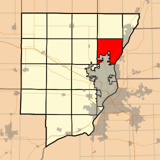
East Peoria is a city in Tazewell County, Illinois, United States. The population was 22,484 at the 2020 census. East Peoria is a suburb of Peoria and is part of the Peoria, Illinois Metropolitan Statistical Area, located across the Illinois River from downtown Peoria. It is home to many Caterpillar Inc. facilities.

Atoka is a local government area with a town charter in Tipton County, Tennessee, United States. In 1888, Atoka was a stop on the Newport News & Mississippi Valley Railroad. Today the City of New Orleans Amtrak passenger train makes its daily route between New Orleans and Chicago, through Atoka. The population was 10,008 at the 2020 census, making the Town of Atoka the largest municipality in Tipton County.

Illinois Route 6 is a 4-lane freeway entirely in Peoria County in central Illinois. It begins as a northern extension of Interstate 474 at Interstate 74 west of Peoria, and ends at Illinois Route 29 at the 9th Mile in Mossville, south of Chillicothe. The freeway currently has a total length of 10.11 miles (16.27 km), including the connector ramp to Illinois 29.

Illinois Route 29 is a two to four lane state highway that runs south from U.S. Route 6/Illinois Route 89 at Spring Valley to U.S. Route 51/Illinois Route 16 at Pana, running through Pekin, Peoria and Springfield. The nearest major north–south highway, Interstate 39, runs parallel to Illinois 29, but approximately fifty miles to the east. Illinois 29 is 175.36 miles (282.21 km) long.
Illinois Valley Central Unit District 321 is the school district in the northeast corner of Peoria County, Illinois, including the communities of Chillicothe, Mossville, and Rome, Illinois.
Huffman is an unincorporated community of northeastern Harris County, Texas within the Houston, Baytown metropolitan area.

Area codes 309 and 861 are telephone area codes in the North American Numbering Plan (NANP) for the west-central part of the U.S. state of Illinois. The numbering plan area includes cities such as Bloomington, Canton, East Moline, East Peoria, Galesburg, Kewanee, Macomb, Minonk, Moline, Morton, Normal, Pekin, Peoria, Rock Island, Silvis, and many smaller communities in west-central Illinois. Area code 309 was created in 1957 in an split of area code 815. 861 was added to the numbering plan area on February 24, 2023, in formation of an overlay.
Medina Township is located North of Peoria, in Peoria County, Illinois, and in the Illinois River Valley. As of the 2010 census, its population was 12,564 and it contained 4,993 housing units.

Edwards is an unincorporated community in Peoria County, Illinois, United States. Edwards is located on Illinois Route 8 northwest of downtown Peoria. Edwards has a post office with ZIP Code 61528; the Post Office is now located on Dubois Road just south of Interstate 74 exit 82, 2.1 miles (3.4 km) north of the original Edwards.
Trivoli is an unincorporated community in Peoria County, Illinois, United States. Trivoli is located along Illinois Route 116 east of Farmington. Trivoli has a part-time post office with ZIP code 61569. It is the former headquarters for Heritage Bank of Central Illinois prior to its sale to Morton Community Bank in 2016.

Illinois Valley Central High School is a public four-year high school located at 1300 West Sycamore Street in Chillicothe, Illinois, a city in Peoria County, Illinois, in the Midwestern United States. IVCHS serves the communities of Chillicothe, Dunlap, Edelstein, Mossville, Peoria, and Rome. The campus is located 15 miles northeast of Peoria, Illinois, and serves a mixed city, village, and rural residential community.
Lockwood is an unincorporated community located along U.S. Route 23 and the Big Sandy River in southern Boyd County, Kentucky, United States, approximately 7 mi south of Catlettsburg, the county seat.
The W. D. Boyce Council of the Boy Scouts of America serves youth in central Illinois, from Lincoln to Ottawa, and Peoria to Bloomington.

Natural Bridge Station is an unincorporated community in Rockbridge County, Virginia, United States, named for both its proximity to Natural Bridge and formerly having a train depot along the Norfolk & Western rail line. Formerly known as Sherwood and Greenlee, the community is located along the James River and Virginia State Route 130, 3.2 miles (5.1 km) west of Glasgow.

Mooresburg is a census-designated place (CDP) and a unincorporated town in Hawkins County, Tennessee, United States. Its population was 941 as of the 2010 census. It is located along U.S. Route 11W between Rogersville and Bean Station.
Coleman Falls is an unincorporated community in northern Bedford County, Virginia, United States. The community is located along the James River and U.S. Route 501, between Big Island and Boonsboro. It is part of the Lynchburg Metropolitan Statistical Area.


