Limestone Township, Peoria County, Illinois

Last updated

LimestoneTownship
Township
Map highlighting Limestone Township, Peoria County, Illinois.svg
Location in Peoria County
Map of Illinois highlighting Peoria County.svg
Peoria County's location in Illinois
Country United States
State Illinois
County Peoria
EstablishedNovember 6, 1849
Area
  Total35.95 sq mi (93.1 km2)
  Land35.7 sq mi (92 km2)
  Water0.26 sq mi (0.7 km2)  0.72%
Population
 (2010)
  Estimate 
(2016) [1]
19,236
  Density552/sq mi (213/km2)
Time zone UTC-6 (CST)
  Summer (DST) UTC-5 (CDT)
FIPS code 17-143-43523

Limestone Township is located in Peoria County, Illinois. As of the 2020 census, its population was 18,357 and it contained 8,111 housing units. [2]

Contents

For the census year of 2010, its population was 19,705 and it contained 8,103 housing units. [3]

History

Limestone Township was named from the abundance of limestone and attendant lime kilns in the area. [4]

Geography

According to the 2010 census, the township has a total area of 35.95 square miles (93.1 km2), of which 35.7 square miles (92 km2) (or 99.30%) is land and 0.26 square miles (0.67 km2) (or 0.72%) is water. [3]

Demographics

Historical population
CensusPop.Note
2016 (est.)19,236 [1]
U.S. Decennial Census [5]

Related Research Articles

<span class="mw-page-title-main">Flagg Township, Ogle County, Illinois</span> Township in Illinois, United States

Flagg Township is located in Ogle County, Illinois. As of the 2010 census, its population was 13,562 and it contained 5,525 housing units.

<span class="mw-page-title-main">Roscoe Township, Winnebago County, Illinois</span> Township in Illinois, United States

Roscoe Township is located in Winnebago County, Illinois. As of the 2010 census, its population was 19,694 and it contained 7,497 housing units.

<span class="mw-page-title-main">Ridott Township, Stephenson County, Illinois</span> Township in Illinois, United States

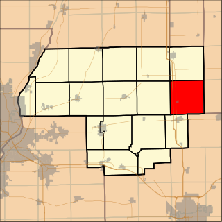
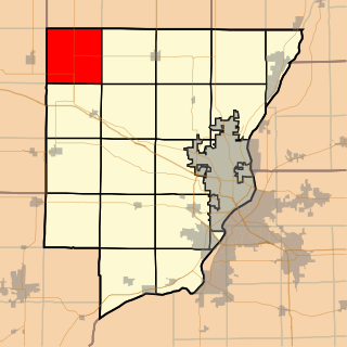
Ridott Township is located in Stephenson County, Illinois, USA. At the 2010 census, its population was 1,451 and it contained 612 housing units. The villages of Ridott and German Valley are located in this township.

<span class="mw-page-title-main">Hahnaman Township, Whiteside County, Illinois</span> Township in Illinois, United States

Hahnaman Township is located in Whiteside County, Illinois. As of the 2010 census, its population was 399 and it contained 148 housing units.

<span class="mw-page-title-main">Barrington Township, Cook County, Illinois</span> Township in Illinois, United States

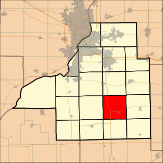
Barrington Township is one of 29 townships in Cook County, Illinois, USA. As of the 2020 census, its population was 16,514 and it contained 6,172 housing units. The northwestern corner of the Cook County panhandle, it is the county's northwesternmost township. It is also by far the least densely populated township in the county, with less than half the population density of the next least Lemont Township.

<span class="mw-page-title-main">St. Clair Township, St. Clair County, Illinois</span> Township in Illinois, United States

St. Clair Township is located in St. Clair County, Illinois. As of the 2010 census, its population was 35,498 and it contained 15,366 housing units. St. Clair Township formed from a portion of Belleville Township on October 5, 1885.

<span class="mw-page-title-main">Kansas Township, Woodford County, Illinois</span> Township in Illinois, United States

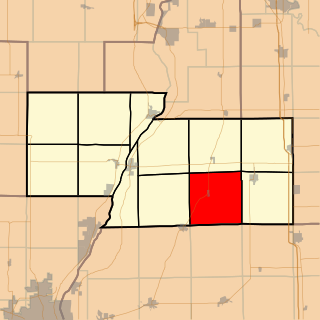
Kansas Township is located in Woodford County, Illinois. As of the 2010 census, its population was 433 and it contained 172 housing units. Kansas Township formed from Palestine Township in September, 1859.

<span class="mw-page-title-main">Panola Township, Woodford County, Illinois</span> Township in Illinois, United States

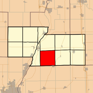
Panola Township is located in Woodford County, Illinois at T27N, R2E. As of the 2010 census, its population was 353 and it contained 144 housing units. Panola Township and Minonk Township were originally the same township, but formed two new townships on an unknown date.

<span class="mw-page-title-main">Palestine Township, Woodford County, Illinois</span> Township in Illinois, United States

Palestine Township is located in Woodford County, Illinois. As of the 2010 census, its population was 1,043 and it contained 424 housing units.

<span class="mw-page-title-main">Hopedale Township, Tazewell County, Illinois</span> Township in Illinois, United States

Hopedale Township is located in Tazewell County, Illinois. As of the 2010 census, its population was 1,913 and it contained 806 housing units. Hopedale Township changed its name from Highland Township on May 20, 1850.

<span class="mw-page-title-main">Morton Township, Tazewell County, Illinois</span> Township in Illinois, United States

Morton Township is located in Tazewell County, Illinois, at T25N R3W. It is traversed by Interstate Routes 74 and 155, about 15 km (10 mi) southeast of Peoria, Illinois.

<span class="mw-page-title-main">Dry Grove Township, McLean County, Illinois</span> Township in Illinois, United States

Dry Grove Township is located in McLean County, Illinois. As of the 2010 census, its population was 1,572 and it contained 618 housing units.

<span class="mw-page-title-main">Mount Hope Township, McLean County, Illinois</span> Township in Illinois, United States

Mount Hope Township is located in McLean County, Illinois. As of the 2010 census, its population was 1,103 and it contained 455 housing units.

<span class="mw-page-title-main">Laenna Township, Logan County, Illinois</span> Township in Illinois, United States

Laenna Township is located in Logan County, Illinois. As of the 2010 census, its population was 584 and it contained 282 housing units.

<span class="mw-page-title-main">Bell Plain Township, Marshall County, Illinois</span> Township in Illinois, United States

Bell Plain Township, Township 29 North, Range 1 West, is located in Marshall County, Illinois. It includes the villages of Pattonsburg and La Rose and is traversed by State Highway 29 and the BNSF Railway.

<span class="mw-page-title-main">Richland Township, Marshall County, Illinois</span> Township in Illinois, United States

Richland Township is located in Marshall County, Illinois. As of the 2010 census, its population was 446 and it contained 195 housing units.

<span class="mw-page-title-main">Millbrook Township, Peoria County, Illinois</span> Township in Illinois, United States

Millbrook Township is located in Peoria County, Illinois. As of the 2020 census, its population was 419 and it contained 192 housing units.

<span class="mw-page-title-main">Princeville Township, Peoria County, Illinois</span> Township in Illinois, United States

Princeville Township is located in Peoria County, Illinois. As of the 2010 census, its population was 1,628 and it contained 674 housing units. The township shares a border with Stark County to the North. It also borders Millbrook Township to the West, Akron Township to the East, and the Jubilee Township to the South.

<span class="mw-page-title-main">Radnor Township, Peoria County, Illinois</span> Township in Illinois, United States

Radnor Township is located in Peoria County, Illinois. As of the 2010 census, its population was 3,613 and it contained 1,330 housing units. Radnor Township was named after Radnor, Pennsylvania.

<span class="mw-page-title-main">Trivoli Township, Peoria County, Illinois</span> Township in Illinois, United States

Trivoli Township is located in Peoria County, Illinois. As of the 2010 census, its population was 1,021 and it contained 447 housing units.

References

  1. 1 2 "Population and Housing Unit Estimates" . Retrieved June 9, 2017.
  2. "Explore Census Data". data.census.gov. Retrieved May 6, 2024.
  3. 1 2 "Population, Housing Units, Area, and Density: 2010 - County -- County Subdivision and Place -- 2010 Census Summary File 1". United States Census. Archived from the original on February 12, 2020. Retrieved May 28, 2013.
  4. Chicago and North Western Railway Company (1908). A History of the Origin of the Place Names Connected with the Chicago & North Western and Chicago, St. Paul, Minneapolis & Omaha Railways. p. 94.
  5. "Census of Population and Housing". Census.gov. Retrieved June 4, 2016.

40°40′23″N89°42′08″W / 40.67306°N 89.70222°W / 40.67306; -89.70222