The National Road was the first major improved highway in the United States built by the federal government. Built between 1811 and 1837, the 620-mile (1,000 km) road connected the Potomac and Ohio Rivers and was a main transport path to the West for thousands of settlers. When improved in the 1830s, it became the second U.S. road surfaced with the macadam process pioneered by Scotsman John Loudon McAdam.

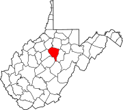
Fayette County is a county in the Commonwealth of Pennsylvania. It is located in southwestern Pennsylvania, adjacent to Maryland and West Virginia. As of the 2020 census, the population was 128,804. Its county seat is Uniontown. The county was created on September 26, 1783, from part of Westmoreland County and named after the Marquis de Lafayette.

Brownsville is a borough in Fayette County, Pennsylvania, United States, first settled in 1785 as the site of a trading post a few years after the defeat of the Iroquois enabled a resumption of westward migration after the Revolutionary War. The trading post soon became a tavern and inn and was receiving emigrants heading west, as it was located above the cut bank overlooking the first ford that could be reached to those descending from the Allegheny Mountains. Brownsville is located 40 miles (64 km) south of Pittsburgh along the east bank of the Monongahela River.

West Brownsville is a former important transportation nexus and a present-day borough in Washington County, Pennsylvania, United States and part of the Pittsburgh metropolitan area. The population was 972 at the 2020 census. Culturally, by postal route, and socially, the community is connected to cross-river sister-city Brownsville, for the two were long joined by the Amerindian trail known as Nemacolin's Path that became a wagon road after the American Revolution, but West Brownsville is a separate municipality. Brownsville was the first point where the descent from the Appalachians could safely reach the river down the generally steep banks of the Monongahela River. Between Brownsville and West Brownsville was a shallow stretch, usable as a river ford astride a major Emigrant Trail to the various attractive regions in the Northwest Territory, the first National Road, the Cumberland Pike.
Brownsville may refer to:

The Monongahela Railway was a coal-hauling short line railroad in Pennsylvania and West Virginia in the United States. It was jointly controlled originally by the Pennsylvania Railroad, New York Central subsidiary Pittsburgh and Lake Erie Railroad, and the Baltimore and Ohio Railroad, with NYC and PRR later succeeded by Penn Central Transportation. The company operated its own line until it was merged into Conrail on May 1, 1993.
Redstone Old Fort — or Redstone Fort or Fort Burd — on the Nemacolin Trail, was the name of the French and Indian War-era wooden fort built in 1759 by Pennsylvania militia colonel James Burd to guard the ancient Indian trail's river ford on a mound overlooking the eastern shore of the Monongahela River in what is now Fayette County, Pennsylvania near, or on the banks of Dunlap's Creek at the confluence. The site is unlikely to be the same as an earlier fort the French document as Hangard dated to 1754 and which was confusedly, likely located on the nearby stream called Redstone Creek. Red sandstones predominate the deposited rock column of the entire region.
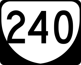
State Route 240 is a primary state highway in the U.S. state of Virginia. The state highway runs 4.51 miles (7.26 km) between junctions with U.S. Route 250 in Brownsville and near Ivy. SR 240 is an L-shaped route that forms the old alignment of US 250 through Crozet in western Albemarle County.
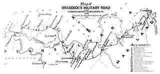
Nemacolin's Trail, or less often Nemacolin's Path, was an ancient Native American trail that crossed the great barrier of the Allegheny Mountains via the Cumberland Narrows Mountain pass, connecting the watersheds of the Potomac River and the Monongahela River in the present-day United States of America. Nemacolin's Trail connected what are now Cumberland, Maryland and Brownsville, Pennsylvania.
Christian Tarr was a member of the U.S. House of Representatives from Pennsylvania.

U.S. Route 40 enters Pennsylvania at West Alexander. It closely parallels Interstate 70 (I-70) from West Virginia until it reaches Washington, where it follows Jefferson Avenue and Maiden Street.In Washington, US 40 passes to the south of Washington & Jefferson College. Following Maiden Street out of town, the road turns southeast toward the town of California. A short limited access highway in California and West Brownsville provides an approach to the Lane Bane Bridge across the Monongahela River. From here, the road continues southeast to Uniontown.
Pentress is a census-designated place (CDP) in northern Monongalia County, West Virginia, United States. It lies along West Virginia Route 7 northwest of the city of Morgantown, the county seat of Monongalia County. Its elevation is 951 feet (290 m). "Pentress" is not the only name the community has had; at various times in its history, it has been known as Minors Mills, New Brownsville, Pentrees, Pentress Junction, Statler Town, Statlers Town, Statlersville, and Stradlerstown. The present name of Pentress was selected by an early settler who reportedly wanted a Welsh name. It has a post office with the ZIP Code of 26544. As of the 2010 census, its population was 175.

Brownsville Road is a road between Pittsburgh, at Eighteenth Street and South Avenue in Allegheny County, Pennsylvania eastwards through Mount Oliver and generally highlands situated along or near the hilltops often overlooking the Monongahela River. It has had several names over its history, and was also known at the Red Stone Road and the period it was a Plank Road managed as a toll road, the Brownsville Plank Road, or the Brownsville Turnpike, or locally, as the area grew into a city, Southern Avenue.
Brownsville is an unincorporated community in Albemarle County, Virginia.
The Pittsburgh, Virginia and Charleston Railway was a predecessor of the Pennsylvania Railroad in the U.S. state of Pennsylvania. By 1905, when it was merged into the Pennsylvania, it owned a main line along the left (west) side of the Monongahela River, to Pittsburgh's South Side from West Brownsville. Branches connected to the South-West Pennsylvania Railway in Uniontown via Redstone Creek and to numerous coal mines.
Gilberto Hinojosa is an American politician. He is the chair of the Texas Democratic Party. Hinojosa was the county judge of Cameron County, Texas from 1995 to 2006.

The Malden Inn is an historic, American building that is located in the unincorporated bedroom community of Malden, Pennsylvania at the junction of South Malden Road and Old U.S. Route 40 (US40).
Blainsburg is an unincorporated outlier community of West Brownsville, PA; by tradition a hamlet sized neighborhood with more actual housing acreage than West Brownsville proper in Washington County, Pennsylvania, United States. Named after a U.S. Senator, James G. Blaine. Blainsburg is part of the California Area School District. West Brownsville residence students attend Brownsville Area School District in Fayette County, Pennsylvania. The bedroom community is situated on the bluff above and slightly North-northwest of West Brownsville on the river bottom below. Blainsburg is located alongside but above the climb PA Route 88 makes from the W. Brownsville river flats which bends right entering a shelf where it connects with the northwest streets of Blainsburg before taking a second ascent towards California. The parent and child communities are on the inside curve of a great meander in the Monongahela River in Southwestern Pennsylvania creating a degraded cut bank turned ramp and terrace on the opposite shore where Brownsville is situated. Blainsburg is often misspelled with an "E" in it, to match the spelling of its namesake, James G. Blaine. Blainsburg as of official records was founded in 1906 and is still spelled without the "E".

Flint Ridge Ancient Quarries and Nature Preserve is a Native American flint quarry located in Hopewell Township, Licking County, Ohio, about three miles north of Brownsville at the intersection of Brownsville Road and Flint Ridge Road. Old quarry pits are visible, and a museum is located on the site.

The belled buzzard is a fearsome critter in American folklore frequently cited as an omen of disaster by the sounding of its bell. The animal is otherwise depicted as an ordinary buzzard except with a bell affixed to it. The belled buzzard originated from actual accounts of turkey vultures being fastened with cow or sleigh bells. The belief that the belled buzzard was one continuous entity, and not multiple birds, was common, and the creature rose to prominence in the 1880s on through the turn of the twentieth century. Belled buzzard stories circulated principally throughout the Southern United States, and it is the origin of the colloquialism "not enough sense to bell a buzzard."