Dale City is a census-designated place (CDP) in Prince William County, Virginia, United States, located 25 miles south west of Washington, D.C. It is an annex of Woodbridge, Virginia. As of 2017, the total population was 73,384. The community is roughly bounded by Hoadly Road to the northwest, Prince William Parkway to the north, Smoketown Road to the northeast, Gideon Drive to the east, and Cardinal Drive to the south.

Glen Dale is a city in Marshall County, West Virginia, United States, along the Ohio River. It is part of the Wheeling, West Virginia Metropolitan Statistical Area. The population was 1,526 at the 2010 census. Glen Dale was incorporated in 1924.

Jean Lesage, was a Canadian lawyer and politician from Quebec. He served as the 19th Premier of Quebec from 22 June 1960 to 16 June 1966. Alongside Georges-Émile Lapalme, René Lévesque and others, he is often viewed as the father of the Quiet Revolution. Quebec City International Airport was officially named in his honour on 31 March 1994, and a provincial electoral district, Jean-Lesage, was named for him, as well.
Marcus Daly was an Irish-born American businessman known as one of the three "Copper Kings" of Butte, Montana, United States.

Wensleydale is the dale or upper valley of the River Ure on the east side of the Pennines, one of the Yorkshire Dales in North Yorkshire, England.

The National Radio Quiet Zone (NRQZ) is a large area of land in the United States designated as a radio quiet zone, in which radio transmissions are heavily restricted by law to facilitate scientific research and the gathering of military intelligence. Roughly half of the zone is located in the Blue Ridge Mountains of west-central Virginia while the other half is the Allegheny Mountains of east-central West Virginia; a small part of the zone is in the southernmost tip of the Maryland panhandle.

Sir Thomas Dale was an English naval commander and deputy-governor of the Virginia Colony in 1611 and from 1614 to 1616. Governor Dale is best remembered for the energy and the extreme rigour of his administration in Virginia, which established order and in various ways seems to have benefited the colony, although he was criticised for high-handedness. He is also credited with the establishment of Bermuda Hundred, Bermuda Cittie, and the Cittie of Henricus.

Augusta is an unincorporated community in central Hampshire County, West Virginia. It is located along the Northwestern Turnpike at the northern terminus of Augusta-Ford Hill Road between Shanks and Pleasant Dale, east of Romney. According to the 2000 census, the Augusta community has a population of 4,728.
Pleasant Dale is an unincorporated community in Hampshire County in the U.S. state of West Virginia. Pleasant Dale is located between Capon Bridge and Augusta on the Northwestern Turnpike. Tearcoat Creek flows through Pleasant Dale and offers whitewater rafting in the Spring from the U.S. Route 50 bridge to its confluence with the North River.
Laurel Dale is an unincorporated community on New Creek in Mineral County, West Virginia, United States. Laurel Dale was established in 1878. The community is located along West Virginia Route 93.
Thomas Dale High School is a public high school located in Chester, an unincorporated community in Chesterfield County, Virginia, United States.

U.S. Route 50 in West Virginia runs from the border with Ohio to Virginia, passing briefly through Garrett County, Maryland, and following the Northwestern Turnpike. Prior to the U.S. Highway System it was West Virginia Route 1 and in the 1930s, the road was not finished in Maryland. Today the section of US 50 from Clarksburg to Parkersburg on the Ohio River is part of Corridor D of the Appalachian Development Highway System.
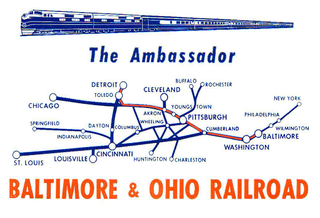
The Ambassador was a named train of the Baltimore and Ohio Railroad (B&O) on its route between Baltimore, Maryland and Detroit, Michigan with major station stops in Washington, D.C. and Pittsburgh, Pennsylvania and Toledo, Ohio. Inaugurated in 1930, the Ambassador was discontinued in 1964.

Sycamore Dale is a 19th-century Greek Revival plantation house overlooking the South Branch Potomac River southwest of Romney, West Virginia. Sycamore Dale is one of several historic estates along South Branch River Road. It was listed on the National Register of Historic Places on December 2, 1980.
Spring Dale is an unincorporated community in Fayette County, West Virginia, United States. Spring Dale is located on West Virginia Route 20 3 miles (4.8 km) northeast of Meadow Bridge. Spring Dale has a post office with ZIP code 25986.
Quiet Dell is an unincorporated community in Harrison County, West Virginia, United States. Quiet Dell is located at the junction of Interstate 79 and West Virginia Route 20, 5 miles (8.0 km) southeast of Clarksburg.
Ben Dale is an unincorporated community in Lewis County, West Virginia, United States.
The term or name Dale appears in a number of place names in the American state of Virginia. Unless stated otherwise, a listed place is a town, or unincorporated community.
Dale is an unincorporated community in Tyler County, in the U.S. state of West Virginia.

Ona Speedway is an Auto racing oval short track venue located in Ona, West Virginia. Ona Speedway is known for being the only paved oval race track in West Virginia and hosting NASCAR Cup Series races in 1963, 1964, 1970, & 1971. It is located adjacent to the Ona Airpark between the cities of Huntington, WV and Charleston, WV.