The Ohio River is a 981-mile (1,579 km) long river in the United States. It is located in the Midwestern and Southern United States, flowing southwesterly from western Pennsylvania south of Lake Erie to its mouth on the Mississippi River at the southern tip of Illinois. It is the third largest river by discharge volume in the United States and the largest tributary by volume of the north-south flowing Mississippi River that divides the eastern from western United States. The river flows through or along the border of six states, and its drainage basin includes parts of 14 states. Through its largest tributary, the Tennessee River, the basin includes several states of the southeastern U.S. It is the source of drinking water for three million people.

West Virginia is a state in the Appalachian, Mid-Atlantic and Southeastern regions of the United States. It is bordered by Pennsylvania to the northeast, Maryland to the east and northeast, Virginia to the southeast, Kentucky to the southwest, and Ohio to the northwest. West Virginia is the 41st-largest state by area and ranks 38th in population, with a population of 1,795,045 residents. The capital and largest city is Charleston.

The Potomac River is found within the Mid-Atlantic region of the United States and flows from the Potomac Highlands into the Chesapeake Bay. The river is approximately 405 miles (652 km) long, with a drainage area of about 14,700 square miles (38,000 km2). In terms of area, this makes the Potomac River the fourth largest river along the East Coast of the United States and the 21st largest in the United States. Over 5 million people live within the Potomac watershed.

Hampshire County is a county in the U.S. state of West Virginia. As of the 2010 census, the population was 23,964. Its county seat is Romney, West Virginia's oldest town (1762). The county was created by the Virginia General Assembly in 1754, from parts of Frederick and Augusta Counties (Virginia) and is the state's oldest county. The county lies in both West Virginia's Eastern Panhandle and Potomac Highlands regions.

The Ridge-and-Valley Appalachians, also called the Ridge and Valley Province or the Valley and Ridge Appalachians, are a physiographic province of the larger Appalachian division and are also a belt within the Appalachian Mountains extending from southeastern New York through northwestern New Jersey, westward into Pennsylvania and southward into Maryland, West Virginia, Virginia, Kentucky, Tennessee, Georgia and Alabama. They form a broad arc between the Blue Ridge Mountains and the Appalachian Plateau physiographic province. They are characterized by long, even ridges, with long, continuous valleys in between.

The Little Kanawha River is a tributary of the Ohio River, 169 mi (269 km) long, in western West Virginia in the United States. Via the Ohio, it is part of the watershed of the Mississippi River, draining an area of 2,320 mi² (6,009 km²) on the unglaciated portion of the Allegheny Plateau. It served as an important commercial water route in the early history of West Virginia, particularly in the logging and petroleum industries.

The Shenandoah River is a tributary of the Potomac River, 55.6 miles (89.5 km) long with two forks approximately 100 miles (160 km) long each, in the U.S. states of Virginia and West Virginia. The principal tributary of the Potomac, the river and its tributaries drain the central and lower Shenandoah Valley and the Page Valley in the Appalachians on the west side of the Blue Ridge Mountains, in northwestern Virginia and the Eastern Panhandle of West Virginia.

"Take Me Home, Country Roads", also known simply as "Take Me Home" or "Country Roads", is a song written by Bill Danoff, Taffy Nivert and John Denver about West Virginia. It was released as a single performed by Denver on April 12, 1971, peaking at number two on Billboard's US Hot 100 singles for the week ending August 28, 1971. The song was a success on its initial release and was certified Gold by the RIAA on August 18, 1971, and Platinum on April 10, 2017. The song became one of John Denver's most popular and beloved songs. It has continued to sell, with over 1.6 million digital copies sold in the United States.

Little Cacapon is an unincorporated community in Hampshire County in the U.S. state of West Virginia. Little Cacapon is located at the mouth of the Little Cacapon River on the Potomac, east of Okonoko. Okonoko-Little Cacapon Road and Spring Gap-Neals Run Road converge south of Little Cacapon. Because of its key location at the mouth of the Little Cacapon and on the Baltimore and Ohio Railroad, Little Cacapon played important roles in both the French and Indian and American Civil Wars. Generally pronounced kə-KAY-pən. Sometimes, despite the current spelling of the word some locals say KAY-pən.
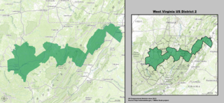
West Virginia's 2nd congressional district stretches from the Ohio River border with Ohio to the Potomac River border with Maryland and the border with Virginia. It includes the capital city of Charleston and the rapidly growing residential communities of West Virginia's Eastern Panhandle and Potomac Highlands regions connected by a narrow strip of nearly unpopulated counties. It is 20 miles (32 km) wide and 300 miles (480 km) long.
Little Beaver State Park is state park in Raleigh County, West Virginia. It is located near Beckley, West Virginia, about 2 miles (3.2 km) south of I-64 at Grandview Road, exit 129A. The park sits on the shores of 18-acre (0.07 km²) Little Beaver Lake.

Little Indian Creek Wildlife Management Area is located on 1,036 acres (419 ha) southwest of Westover in Monongalia County, West Virginia. The wildlife management area is centered on reclaimed former coal mine land along Little Indian Creek, a tributary of the Monongahela River.

Hughes River Wildlife Management Area is located in Wirt County and Ritchie County near Parkersburg, West Virginia. Located on 10,000 acres (4,000 ha) that border both the Little Kanawha River and the Hughes River. The WMA terrain varies from river bottom to steep hillsides covered with second growth oak-hickory hardwood stands and younger pine-hardwood woodlots.
The South Region was a region that competed in the Little League World Series between 1957 and 2000 until it was split into the Southwest and Southeast regions in 2001.
Little Falls is an unincorporated community in Monongalia County, West Virginia, United States. Little Falls is located along the Monongahela River, 5.5 miles (8.9 km) south-southwest of Morgantown.
Little Italy is an unincorporated community in Randolph County, West Virginia, USA. Little Italy is located on Gandy Creek and County Route 29/5 1.3 miles (2.1 km) south of Whitmer and 18.5 miles (29.8 km) east-southeast of Elkins.
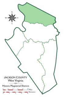
Grant District, formerly Grant Magisterial District, is one of five historic magisterial districts in Jackson County, West Virginia, United States. The district was originally established as a civil township in 1863, and converted into a magisterial district in 1872. When Jackson County was redistricted in the 1990s, the area of Grant District was included in the new Northern Magisterial District. However, the county's historic magisterial districts continue to exist in the form of tax districts, serving all of their former administrative functions except for the election of county officials.