Warren County is a rural county located in the U.S. state of Iowa. As of the 2010 census, the population was 46,225. The county seat is Indianola.

Churchville is a village in Monroe County, New York. According to the 2010 census, the population is 1,961. The village is named after Samuel Church, an early settler.

Riga is a town in Monroe County, New York. The population was 5,590 at the 2010 census.

Churchville is a census-designated place (CDP) in Northampton Township, Bucks County, Pennsylvania, United States. The population was 4,128 at the 2010 census.

Northampton Township is a township in Bucks County, Pennsylvania, United States, about 12 miles northeast of Philadelphia. The population was 39,726 at the 2010 census.
"Still Valley" is episode 76 of the American television anthology series The Twilight Zone.
Churchville can refer to a location in North America:
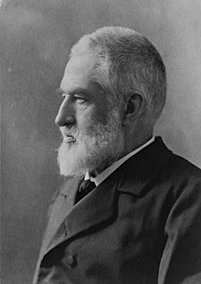
Jedediah Hotchkiss, known most frequently as Jed, was an educator and the most famous cartographer and topographer of the American Civil War. His detailed and accurate maps of the Shenandoah Valley are credited by many as a principal factor in Confederate General Stonewall Jackson's victories in the Valley Campaign of 1862.
Churchville is an unincorporated community in Harford County, Maryland, United States, situated between the county seat, Bel Air, and Aberdeen, where the Aberdeen Proving Ground is located.
Churchville station is a former train station in Churchville, Pennsylvania. Located on Knowles Avenue and Bustleton Pike, it is now a private residence.

Swoope is an unincorporated community in Augusta County, Virginia. Swoope is located on State Routes 703 and 860 7.4 miles (11.9 km) west of Staunton. Swoope has a post office with ZIP code 24479, which opened on March 6, 1838. Polyface Farm, a sustainable farm run by Joel Salatin, is also near Swoope. Students in the area go to Beverley Manor Elementary School, Churchville Elementary School, attend Beverley Manor Middle School, and Buffalo Gap High School.

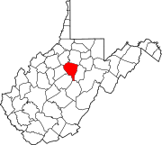
Churchville is a census-designated place (CDP) in the western part of Augusta County, Virginia, United States. The population as of the 2010 Census was 194. Churchville is part of the Staunton–Waynesboro Micropolitan Statistical Area.
The Churchville-Chili Central School District (CCCSD) is a public school district in Monroe County, New York, near Rochester. It serves approximately 3,816 students in grades K through 12 from the towns of Chili, Ogden, Riga and Sweden, and from the village of Churchville. The district has 823 employees and an operating budget of $88,467,407 (2020-21).

Churchville is a preserved suburban hamlet in the south-west corner of Brampton, Ontario, Canada. It is designated as a heritage community under the Ontario Heritage Act.
John Rudolph Niernsee was an American architect. He served as the head architect for the Baltimore and Ohio Railroad. Rudolph also largely contributed to the design and construction of the South Carolina State House located in Columbia, South Carolina. Along with his partner, James Crawford Neilson, Rudolph established the standard for professional design and construction of public works projects within Baltimore and across different states in the United States.

The Staunton–Waynesboro Metropolitan Statistical Area is a United States Metropolitan Statistical Area (MSA) in Virginia, as defined by the Office of Management and Budget (OMB). As of the 2010 census, the MSA had a population of 118,502.

Deerfield is a census-designated place (CDP) in Augusta County, Virginia, United States. The population as of the 2010 Census was 132. It has a very low population density, as it is a small unincorporated rural area. The Deerfield mall is the main store of the town. Deerfield consists of farms, hunting areas, old plantation houses, and scenic views of the mountains. Deer, bear, and other forms of wildlife fill the area. Deerfield has its own post office, fire department, rescue squad, dump, and a historic school house. Students who live in Deerfield attend Churchville Elementary School, Beverley Manor Middle School, and Buffalo Gap High School.

James Crawford Neilson, or J. Crawford Neilson, was a Baltimore, Maryland-based architect. He was born in Baltimore, Maryland in 1816. After the death of his father in 1822 the family moved to England and in 1824 to Brussels. In 1833, he returned to Baltimore and in 1835, became a member of the survey party working on the Baltimore and Port Deposit Railroad,. His supervisor was Benjamin Henry Latrobe, II, (1806-1878), later supervising engineer on the Baltimore and Ohio Railroad,, son of an equally famous architect, Benjamin Henry Latrobe, (1764-1820). It was at this time that he first became acquainted with John Rudolph Niernsee, (1814-1885), while helping to survey in the area of Martinsburg, Virginia, for the Baltimore and Ohio Railroad.

Churchville is an unincorporated community in Warren County, Iowa, United States. It is located in Jefferson Township at the intersection of Churchville Street and 30th Avenue. It is 1.5 miles (2.4 km) southwest of Prole and two miles (3.2 km) north of Martensdale at an altitude of 971 feet (296 m).

Churchville Nature Center is a facility of the Bucks County, Pennsylvania Department of Parks and Recreation and is located in Churchville, Pennsylvania. The center focuses on environmental education, public outreach and the preservation of native wildlife through its wide range of programs, projects and surveys. The nature center offers educational programing year round through its Environmental Education and Lenape Village departments. The center features a native butterfly house and covers 55 acres of wildlife preserve.