Brushy Creek State Recreation Area

Last updated
Brushy Creek State Recreation Area
USA Iowa location map.svg
Red pog.svg
Location of Brushy Creek State Recreation Area in Iowa
Location Webster, Iowa, United States
Coordinates 42°23′29″N93°59′3″W / 42.39139°N 93.98417°W / 42.39139; -93.98417 Coordinates: 42°23′29″N93°59′3″W / 42.39139°N 93.98417°W / 42.39139; -93.98417
Area6,500 acres (26 km2)
Elevation1,050 ft (320 m)
Governing bodyIowa Department of Natural Resources
Website Brushy Creek State Recreational Area

Brushy Creek State Recreation Area is a state park in Webster County, Iowa in the United States. With an area encompassing over 6,000 acres (24 km2), the facility is one of Iowa's largest public outdoor recreation areas.

State park protected area managed at the federated state level

State parks are parks or other protected areas managed at the sub-national level within those nations which use "state" as a political subdivision. State parks are typically established by a state to preserve a location on account of its natural beauty, historic interest, or recreational potential. There are state parks under the administration of the government of each U.S. state, some of the Mexican states, and in Brazil. The term is also used in the Australian state of Victoria. The equivalent term used in Canada, Argentina, South Africa and Belgium, is provincial park. Similar systems of local government maintained parks exist in other countries, but the terminology varies.

Iowa State of the United States of America

Iowa is a state in the Midwestern United States, bordered by the Mississippi River to the east and the Missouri River and Big Sioux River to the west. It is bordered by six states; Wisconsin to the northeast, Illinois to the east, Missouri to the south, Nebraska to the west, South Dakota to the northwest and Minnesota to the north.

United States federal republic in North America

The United States of America (USA), commonly known as the United States or America, is a country composed of 50 states, a federal district, five major self-governing territories, and various possessions. At 3.8 million square miles, the United States is the world's third or fourth largest country by total area and is slightly smaller than the entire continent of Europe's 3.9 million square miles. With a population of over 327 million people, the U.S. is the third most populous country. The capital is Washington, D.C., and the largest city by population is New York City. Forty-eight states and the capital's federal district are contiguous in North America between Canada and Mexico. The State of Alaska is in the northwest corner of North America, bordered by Canada to the east and across the Bering Strait from Russia to the west. The State of Hawaii is an archipelago in the mid-Pacific Ocean. The U.S. territories are scattered about the Pacific Ocean and the Caribbean Sea, stretching across nine official time zones. The extremely diverse geography, climate, and wildlife of the United States make it one of the world's 17 megadiverse countries.

Contents

A relatively new recreational area, Brushy Creek did not have an easy beginning. In 1967, the Iowa Department of Natural Resources published a controversial proposal to flood Brushy Creek's forested canyon. The proposal was met with enough public opposition that the idea was debated for the next twenty years. The resultant compromise called for the DNR to protect a sensitive 260-acre (1.1 km2) parcel, construct a smaller lake of 690 acres (2.8 km2), and purchase more land to build equestrian trails (1,750 acres).

Nearby towns

Lehigh is located 5 miles (8.0 km) southwest on county road D45. Duncombe is located 5 miles (8.0 km) north on county road P73. Fort Dodge is located approximately 15 miles (24 km) northwest of Brushy Creek on Hwy 20. Webster City is located approximately 25 miles (40 km) northeast on Hwy 20.

Lehigh, Iowa City in Iowa, United States

Lehigh is a city in Webster County, Iowa, United States. The population was 416 at the 2010 census.

Duncombe, Iowa City in Iowa, United States

Duncombe is a city in Webster County, Iowa, in the United States. The population was 410 at the 2010 census.

Fort Dodge, Iowa City in Iowa, United States

Fort Dodge is a city in and the county seat of Webster County, Iowa, United States, along the Des Moines River. The population was 25,206 in the 2010 census, an increase from 25,136 in the 2000 census. Fort Dodge is a major commercial center for North Central and Northwest Iowa. It is located on U.S. Routes 20 and 169.

Picnicking and shelters

Brushy Creek offers picnic areas around the park, with tables and fire grills. Two open shelters can be reserved online through the park reservation system.

Equestrian camping

Equestrian users can choose one of two modern camp facilities. The northern equestrian campground has a modern shower and restroom, 125 campsites (50 electrical), horse wash area, ample shade, a substantial hitch rail at every site (users are required to tie animals to rails) and a 100' by 200' arena. Water hydrants with potable water are available, as are picnic tables, grills, and a playground. In the future another shower/toilet building will be constructed.

Equestrianism The use of horses for sport or work

Equestrianism, more often known as horse riding or horseback riding, refers to the skill and sport of riding, driving, steeplechasing or vaulting with horses. This broad description includes the use of horses for practical working purposes, transportation, recreational activities, artistic or cultural exercises, and competitive sport.

The south campground has a modern shower and restroom with 62 electric, 22 non-electric sites, and 8 full water and sewer hookup sites with the same amenities as the northern campground. Advance campsite reservations can be reserved online through the park reservation system. Half of the campsites are still available on a first-come, first-served basis.

Non-equestrian camping

The non-equestrian campground has 47 sites including 39 electric sites, and 8 with full water and sewer hookups. This location makes the campground convenient for those using the nearby boat ramp and beach, and is also available for picnicking. Half of these campsites can be reserved online through the park reservation system, and the rest are available on a first-come, first-served basis.

Equestrian day use staging area

There is a day-use staging area near both equestrian campgrounds that users are free to use at no charge for the day. Facilities include seasonal restrooms. Additional staging areas are being developed in the southern area.

Lake activities

Fishing is a popular activity at Brushy Creek. The creek and Des Moines River provide a challenge to the angler with smallmouth bass and panfish as favorite catches. Several boat ramps and fishing jetties are located around the 690-acre (2.8 km2) lake. A fishing pier is located on the west side of the lake, north of the beach area. There are fishing tournaments occurring almost every weekend out on the lake.

Swimming is allowed in the designated beach area only. A large sandy beach is located on the west side of the lake.

Trails

With approximately 45 miles (72 km) of multi-use trails, allowable trail activities include horseback riding, hiking, snowmobiling, cross country skiing, and mountain biking. Mountain biking is allowed on all multiple use trails. A map of these trails is on display at the information kiosks located in the equestrian campgrounds.

Hunting

Hunting is also a popular activity at Brushy Creek. Hunters can pursue a variety of game species ranging from pheasants, quail, rabbits and squirrels to white-tailed deer and wild turkeys. A number of designated parking areas are located throughout Brushy Creek to provide convenient access for the hunter.

Shooting range

Two ranges are located at the Brushy Creek State Recreational Area. One is south of the park office approximately 1/2 mile north of County Rd. D-46. The other is a trap range located in the northern section of the park.

Related Research Articles

Conecuh National Forest

The Conecuh National Forest in southern Alabama covers 83,000 acres (340 km2), along the Alabama - Florida line in Covington and Escambia counties. Topography is level to moderately sloping, broad ridges with stream terraces and broad floodplains.

Gulf Islands National Seashore U.S. national park in Mississippi and Florida

Gulf Islands National Seashore offers recreation opportunities and preserves natural and historic resources along the Gulf of Mexico barrier islands of Florida and Mississippi. The protected regions include mainland areas and parts of seven islands. Some islands along the Alabama coast were originally considered for inclusion, but none is part of the National Seashore.

Osceola National Forest A national forest located Florida

Osceola National Forest is a National Forest located in northeast Florida.

Tettegouche State Park

Tettegouche State Park, in the United States, is a Minnesota state park on the north shore of Lake Superior 58 miles (93 km) northeast of Duluth in Lake County on scenic Minnesota Highway 61. The park's name stems from the Tettegouche Club, an association of local businessmen which purchased the park in 1910 from the Alger-Smith Lumber Company. The club's members protected the area until its sale in 1971 to the deLaittres family. In 1979, the state of Minnesota acquired 3,400 acres (1,400 ha) from the Nature Conservancy, including Tettegouche Camp. The land was added to Baptism River State Park, which was renamed Tettegouche State Park.

Foster Reservoir

Foster Reservoir is a reservoir created by Foster Dam on the South Santiam River in the city of Foster, Oregon, United States. The reservoir is approximately 5.6 km (3.5 mi) long and covers approximately 494 ha when full. Primary use of the reservoir is recreation in the summer and flood control in the winter and spring.

Kikomun Creek Provincial Park provincial park in British Columbia

Kikomun Creek Provincial Park is a provincial park in British Columbia, Canada.

Bear Lake State Park (Utah)

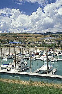
Bear Lake State Park is a state park of Utah, USA, along the shore of Bear Lake on the Idaho border. It offers three recreation areas: Rendezvous Beach, Bear Lake Marina, and East Side, which comprises several more segments. The park also hosts many annual events, such as a Mountain Man Rendezvous and Bear Lake Raspberry Days.

Poe Valley State Park

Poe Valley State Park is a 620-acre (251 ha) Pennsylvania state park in Penn Township, Centre County, Pennsylvania in the United States. The park is surrounded by Bald Eagle State Forest. Poe Paddy State Park is 4 miles (6.4 km) to the east. The forests of the park surround the 25-acre (10 ha) Poe Lake. Poe Valley State Park is in isolated Poe Valley which lies between Potters Mills on U.S. Route 322 and Millheim on Pennsylvania Route 45. The park was closed during the 2008 and 2009 season while the lake was drained for dam repairs and the park facilities were upgraded.

Lake Anita State Park

Lake Anita State Park is a state park of Iowa, US, featuring a 171-acre (69 ha) reservoir on a branch of the Nishnabotna River. The park is located south of Anita on Iowa State Highway 148.

Pinckney State Recreation Area

Pinckney State Recreation Area is a Michigan state recreation area in Dexter, Sylvan and Lyndon Townships, Washtenaw County and Putnam and Unadilla Townships, Livingston County in the U.S. state of Michigan. The park is 11,000 acres (4,500 ha) and sits at an elevation of 922 feet (281 m). The park is connected to the nearby Waterloo State Recreation Area by the 35-mile (56 km) Waterloo–Pinckney Trail. Pinckney State Recreation Area is open for year-round recreation including hiking, fishing, swimming, hunting and a variety of winter sports.

Pine Lake State Park

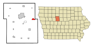
Pine Lake State Park is a state park of Iowa, US. The park comprises 585 acres (237 ha) encompassing two lakes: 50-acre (20 ha) Lower Pine Lake and 69-acre (28 ha) Upper Pine Lake. The park is located near Eldora and Steamboat Rock.

George Wyth Memorial State Park

The George Wyth Memorial State Park is a state park of Iowa in the United States. The park was dedicated in 1940 as "Josh Higgins Parkway", named for a popular radio character of the day. In 1956, it was renamed George Wyth Memorial State Park after a well-known Cedar Falls businessman and conservationist.

Foss State Park

Foss State Park is a 1,749-acre (708 ha) Oklahoma state park located on Foss Lake, in southwestern Custer County, Oklahoma, near the city of Foss.

Lake Sugema lake of the United States of America

Lake Sugema [Pronounced sōō•jē’•mə](+40° 41' 22.85", -91° 59' 39.01") is a man-made 574-acre (2.32 km2) lake 3 miles (4.8 km) southwest of Keosauqua, Van Buren County, in southeast Iowa, United States. It is located south of the Des Moines River, west of State Highway 1 and north of State Highway 2.

Waubonsie State Park

Waubonsie State Park is a state park of Iowa, US, located in the Loess Hills region. It is named for Chief Wabaunsee of Potawatomi tribe.

Springbrook State Park

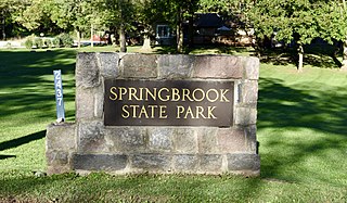
Springbrook State Park is a state park of Iowa, USA, located approximately 5 miles (8.0 km) west of the city of Yale. The park contains a 17-acre (6.9 ha) spring-fed lake and timber-covered rolling hills along the Middle Raccoon River.

Daingerfield State Park

Daingerfield State Park, in Morris County southwest of Texarkana, is a 506.913-acre (2.05140 km2) recreational area, deeded in 1935 by Georgia Anna 'Chambers' Connor, and opened in 1938.

Deam Lake State Recreation Area

Deam Lake State Recreation Area is an Indiana State Recreation Area in Clark County, Indiana in the United States. The park is 1,300 acres (530 ha) and sits at an elevation of 535 feet (163 m). Deam Lake State Recreation area is open for year-round recreation, however the campground closes each year from the Sunday before Thanksgiving to March 1 of the following year. Much of the recreation is centered on Deam Lake. It is named for Charles C. Deam, the first state forester of Indiana.

Lake Manawa State Park

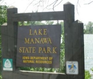
Lake Manawa State Park is located in Council Bluffs, Iowa. It is based around Lake Manawa, a man-made lake created to relieve water from the Missouri River and is located in southwest Council Bluffs.

Willow Creek State Recreation Area (Nebraska)

Willow Creek State Recreation Area (SRA) is a state park in northeastern Nebraska, United States. The recreation area is located on the 700 acre Willow Creek Reservoir, approximately 4 miles (6.4 km) southwest of Pierce, or about 15 miles (24 km) northwest of Norfolk. The recreation area is managed by the Nebraska Game and Parks Commission.