
The Lewis and Clark National and State Historical Parks, in the vicinity of the mouth of the Columbia River, commemorate the Lewis and Clark Expedition. Administration of the parks is a cooperative effort of the United States National Park Service and the states of Oregon and Washington, and was dedicated on November 12, 2004.

Edward "Ted" and Pat Jones-Confluence Point State Park is a public recreation area located on the north side of the Missouri River at its confluence with the Mississippi River in St. Charles County, Missouri. The state park encompasses 1,121 acres (454 ha) of shoreline and bottomland and is managed by the Missouri Department of Natural Resources, which "plans to restore a natural floodplain reminiscent of what Lewis and Clark might have seen along the lower Missouri River." The park is part of the Mississippi Greenway and sits opposite the Columbia Bottom Conservation Area on the south bank of the Missouri River. Park trails will eventually connect with the statewide Katy Trail.
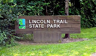
Lincoln Trail State Park is a 1,023-acre (414 ha) Illinois state park located in Clark County, in east-central Illinois, 2 miles (3 km) south of the city of Marshall, just west of Illinois Route 1. The state acquired the first 31 acres (13 ha) of the park in 1936; the park and lake were officially dedicated in 1958.

Stone State Park is a state park of Iowa, USA, located in the bluffs and ravines adjacent to the Big Sioux River. The park consists of 1,069 acres (433 ha) in Woodbury and Plymouth Counties near Sioux City, and overlooks the South Dakota-Iowa border. Stone Park is near the northernmost extent of the Loess Hills, and is at the transition from clay bluffs and prairie to sedimentary rock hills and bur oak forest along the Iowa side of the Big Sioux River. A variety of prairie plants can be found on the steep slopes and ridges, including yucca, penstemon, rough blazing star, silky aster, and pasque flower. Wild turkey, white-tailed deer, coyote, and red fox are found in the park. Birdlife includes the turkey vulture, barred owl, rufous-sided (eastern) towhee, and the ovenbird. Exposed bedrock in the park is composed of lignite, shale, sandstone, and limestone, and dates to the Cretaceous period; it is rich in marine fossils. The park contains many miles of hiking and equestrian trails, and is a popular destination for day visitors, overnight campers, mountain bike enthusiasts, and picnickers.

Big Bend of the Colorado State Recreation Area is a public recreation area located in the Lower Colorado River Valley near the unincorporated town of Laughlin in southern Clark County, Nevada. The park is located directly across the Colorado River from Bullhead City, Arizona, and is approximately 9 miles (14 km) downstream of the Davis Dam. The park has two miles of shoreline and riparian areas. The majority of its 2,100 acres (850 ha) consists of canyons and washes.
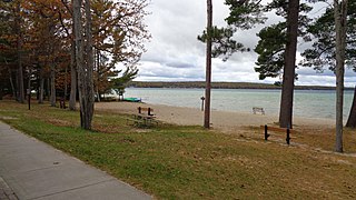
South Higgins Lake State Park is a public recreation area covering 1,000 acres (400 ha) on the southern shore of Higgins Lake five miles southwest of Roscommon in Roscommon County, Michigan. The state park occupies one mile of shoreline on Higgins Lake and entirely surrounds Marl Lake.

Sam A. Baker State Park is a public recreation area encompassing 5,323 acres (2,154 ha) in the Saint Francois Mountains region of the Missouri Ozarks. The state park offers fishing, canoeing, swimming, camping, and trails for hiking and horseback riding. The visitor and nature center is housed in a historic building that was originally constructed as a stable in 1934.

Samuel S. Lewis State Park is an 85-acre (34 ha) Pennsylvania state park in Lower Windsor Township, York County, Pennsylvania, in the United States. Mt. Pisgah is an 885-foot-high (270 m) ridge that is the focus of recreation for the park. The ridge separates East Prospect Valley from Kreutz Creek Valley. An overlook on Mt. Pisgah gives visitors of view of the Susquehanna River Valley. Samuel S. Lewis Park is twelve miles (19 km) east of York near U.S. Highway 30.

Backbone State Park is Iowa's oldest state park, dedicated in 1919. Located in the valley of the Maquoketa River, it is approximately three miles (5 km) south of Strawberry Point in Delaware County. It is named for a narrow and steep ridge of bedrock carved by a loop of the Maquoketa River originally known as the Devil's Backbone. The initial 1,200 acres (490 ha) were donated by E.M. Carr of Lamont, Iowa. Backbone Lake Dam, a relatively low dam built by the Civilian Conservation Corps (CCC) in the 1930s, created Backbone Lake. The CCC constructed a majority of trails and buildings which make up the park.

Rock Creek State Park is a state park of Iowa, US. It is located in Jasper County, near Kellogg.
Lewis and Clark State Park is a public recreation area occupying 189 acres (76 ha) on the south shore of 365-acre (148 ha) Lewis and Clark Lake in Buchanan County, Missouri. The state park features camping, picnicking, and fishing.
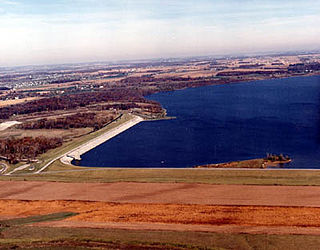
Buck Creek State Park is a 4,016-acre (1,625 ha) Ohio state park in Clark County, Ohio in the United States, around part of Buck Creek. The park is leased by the state of Ohio from the U.S. Army Corps of Engineers. It includes C. J. Brown Reservoir and Dam, a flood control dam and reservoir built by the USACE as part of a flood control system in the Ohio River drainage basin. Buck Creek State Park is open for year-round recreation including camping, boating, hunting, fishing, swimming, picnicking and hiking.

Lewis and Clark State Park is a public recreation area located six miles (9.7 km) northeast of Winlock in Lewis County, Washington. The state park occupies one of the last major stands of old-growth forest in the state. The park's 616 acres (249 ha) include camping areas and trails for hiking and horseback riding. Evidence of the efforts of the Civilian Conservation Corps to improve the park in the 1930s can be found in the park's rustic shelters and restroom facilities.

Lewis and Clark Trail State Park is a 36-acre (15 ha) Washington state park located on the Touchet River in Columbia County with both old-growth forest and 1,333 feet (406 m) of river shoreline. The park offers camping, hiking, fishing, swimming, birdwatching, interpretive activities, wildlife viewing, and athletic fields.

Lake Ahquabi State Park is a state park of Iowa, US, featuring a 115-acre (47 ha) reservoir. Ahquabi means "resting place" in the Fox language. The park is 6 miles (9.7 km) south of Indianola and 22 miles (35 km) south of Des Moines. Three section of the park were listed on the National Register of Historic Places in 1991.

Lewis and Clark State Park is a public recreation area occupying 490 acres (200 ha) on the north shore of the far western, upper reaches of Lake Sakakawea in Williams County, North Dakota. The state park, which is 19 miles east of Williston, is used for fishing, boating, camping, and picnicking.

Harrison Lake State Park is a 142-acre (57 ha) state park located southwest of Fayette, Ohio, established in 1950. The park offers a 3.5-mile hiking trail, 150-foot swimming beach, and a campground with 181 campsites.

Preparation Canyon State Park is located north of Pisgah, Iowa, United States. Located in the Loess Hills, the 344-acre (139 ha) park is a relatively undisturbed and undeveloped place. It provides space for picnicking, hiking, and camping in ten hike-in camp sites. Dramatic ridges are located on the north, south and west sides of the park, which is located on the north end of the Loess Hills State Forest.

Wapsipinicon State Park is located south of Anamosa, Iowa, United States. The 394-acre (159 ha) park is along the sandstone and limestone bluffs of the Wapsipinicon River, from which it derives its name. It is one of the oldest state parks in Iowa, and it was listed as a historic district on the National Register of Historic Places in 2014.
Lake Wapello State Park is a state park located in Davis County in the U.S. state of Iowa. It stands west of the town of Drakesville and contains Lake Wapello.


